
-
 56666 Hits
-
 95.51% Score
-
 53 Votes
|
|
Route |
|---|---|
|
|
37.11304°N / 118.54686°W |
|
|
Hiking |
|
|
Spring, Summer, Fall |
|
|
Most of a day |
|
|
Class 1 |
|
|
Overview

 |  |  |
Commonly known as "Bishop Pass Trail" this is the most popular route to access Dusy Basin and the easiest way to climb Mount Agassiz. Bishop Pass Trail is, however, much more than that. It's truly one of the most scenic trails for day hikers, campers and folks with a fishing rod. When the temperatures in the Owens Valley soar to 100+ degrees, Bishop Pass Trail become a destination of choice. The trailhead is nearly 10,000 feet with a dozen lakes within a few hours of hiking distance.
Round trip distance from South Lake to Bishop Pass is about twelve miles with an elevation gain of about 2200 feet.
 |  |  |

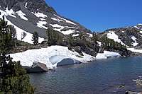
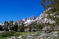
Spearhead Lake and Long Lake

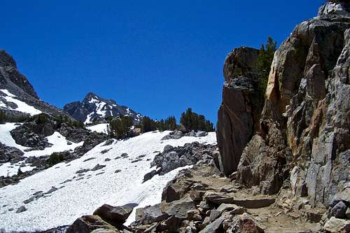
Mount Agassiz
Route Description and points of Interest:
Start your hike some twenty miles west of the town of Bishop on Highway 395, California. South Lake, at an elevation of 9750 feet, has two large parking lots and several smaller parking areas. There are bathroom facilities and bear lockers here. The views of the high Sierras will immediately impress you. The most prominent peaks viewed from South Lake are Mount Gilbert and Hurd Peak. Another point of interest is the wooden dam that created South Lake.
The trail from South Lake drops down a few dozen feet paralleling the shore line, then it begins to slowly gain altitude as it enters the forested area. You will lose the sight of the lake for a while until it crosses a footbridge at the inlet into South Lake. Your next landmark is the intersection with Treasure Lakes Trail, at 10170 feet. Stay left and continue toward Bishop Pass. Your next landmark is the intersection with Marie Louise Lake trail at an elevation of 10, 410, and shortly after the junction with Bull Lake Trail at 10,638 feet.
 |  |  |
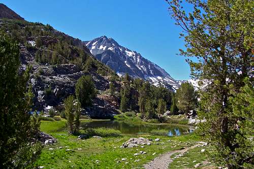

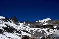
After about an hour you reach the next major lake along Bishop Pass Trail. This is Long Lake at 10,725 feet. The views of Mount Goode become breathtaking. The junction with Ruwau Lake is next, then you pass by Spearhead Lake that is almost connected to Long Lake. Your next stop is the drainage from Timberline Lake where you will have to hop on many rocks to cross the creek. This creek crossing is after you make a sudden turn to the right. As you hike toward your next objective, Saddlerock Lake, you will notice a pyramidal mountain to the right and up the valley. This is point 12,689.
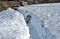
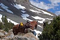
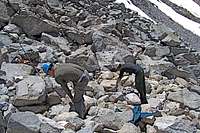
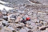
Continuing on the trail past Saddlerock Lake and reaching Bishop Lake, you may find yourself walking through deep corridors of consolidated snow made for pack horses passage until middle of July. Past partially frozen Bishop Lake you get a perfect view of Mount Goode and Mount No Goode together. The southeast slopes are the most common route taken to climb Mount Goode. Continuing toward Bishop Pass you will have to hike through a rough patch covered by a huge rock slide in 2008. The trail has been repaired and a new and safer trail is in the process of being constructed. At this point the trail switch backs up a very steep and unlikely slope. Past this steep section it's a short hop to Bishop Pass, Mount Agassiz to the east and Dusy Basin directly to the south. Have fun.
 |  |  |
How to get there:
From the town of Bishop, California, on Highway 395 take Highway 168 west toward the Sierras. After about twelve miles you will see a sign for South Lake. Turn left here and continue for another six miles to South Lake. The trailhead starts to the left of the restrooms.
 |  |  |
Essential Gear
A good fitting pair of boots, an emergency bag with a flash light, sun screen, Mosquito repellent.External Links
Mount AgassizMount Gilbert
Hurd Peak
Mount Goode
fossana - Aug 6, 2010 11:36 am - Voted 10/10
more peaks for the listCloudripper southern routes on: Winchell Thunderbolt Starlight N Pal Polemonium Sill Also, bear boxes and restrooms at the trailhead. No parking fee.
Marcsoltan - Aug 8, 2010 9:24 pm - Hasn't voted
Re: more peaks for the listI think the best way to climb the peaks on your list is from Palisades Glacier.
fossana - Aug 9, 2010 1:01 am - Voted 10/10
Re: more peaks for the listDepends on which route. The U-notch/V-notch, the E Arete of Winchell, and the Swiss Arete are all accessed via Palisade Glacier. The SW Chute is the most common route up T-bolt and is accessed from the Palisade Basin side (Bishop Pass approach). Also, there are some interesting and infrequently climbed routes on the southern side of Winchell.
Marcsoltan - Aug 9, 2010 9:39 am - Hasn't voted
Re: more peaks for the listI thought we were talking about peaks not routes. In any case, peaks, routes, or routes up peaks, I'd still stick to my original comment.