Overview
The south ridge route on Limestone Mountain is mostly a Class 2 scramble with
some exposed Class 3 ledge crossings. If covered in snow, depending on the
condition of the snow, the route can be downright treacherous. From the
tarn lake at 9870, ascend the south slopes to a prominent gap on the SW
ridge. Follow this ridge to just below an obvious limestone band that
seems to guard the summit. This is a false summit, but contains a nice
view of the real summit. If you would like to get up this for scoping the
route, etc. climb through the only V notch to reach the top of the false
summit. For the true summit, traverse left (toward the north) just under
this limestone band onto some exposed and loose ramps that lead to a point just
north of the lower south summit (false summit). The exposed sections
are easy, and relatively wide, but given the loose rock, caution should be
exercised. A fall in this area would most likely be fatal as the limestone
cliff band drops off. From the prominent notch between the south summit
and the true summit, check out the wind cave with views of the southeast part of
the range. You'll actually be looking through a part of the
mountain. The last 100 feet ascend a very sharp and rocky spine to the
true summit.
South Ridge Route from parking area: (5 Miles, 5009
foot elevation gain - one way)
Getting There
From a well used trail near some historic irrigation remnants, pass a newer gauging station, but as you continue you'll see what was once a massive pipe that went from an old dam, down toward Mackay. At around 2 miles you'll pass an impressive waterfall (most of the year) coming in from the northwest slopes of Wet Peak. After passing the historic dam that was breached, the trail becomes faint and you'll need to scramble through the wooded forests on the sides of the drainage to avoid rock hopping the creek bed. Once the trees disappear at around 8800 feet, the slope gets dramatically steeper as you approach a series of limestone cliffs that are easily circumnavigated. Some of these cliffs may have water seeping down them giving them the appearance of "weeping walls". The tarn lake at 9870 is a prominent landmark, as is the dramatic twin towers above this area. Follow the slope north contouring an obvious drainage line until your on the southwest ridge proper.
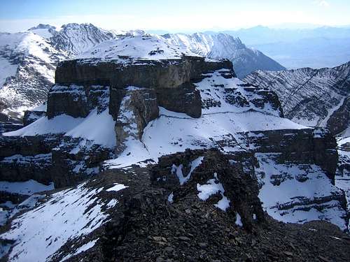
![Limestone Mountain Traverse]() The trail that we cut across the exposed slope is easily visible. It took over an hour of ice-ax and boot scraping hard labor to get through.
The trail that we cut across the exposed slope is easily visible. It took over an hour of ice-ax and boot scraping hard labor to get through.

 2526 Hits
 73.06% Score
 3 Votes

 The trail that we cut across the exposed slope is easily visible. It took over an hour of ice-ax and boot scraping hard labor to get through.