-
 12525 Hits
-
 85.36% Score
-
 20 Votes
|
|
Mountain/Rock |
|---|---|
|
|
44.02135°N / 113.55425°W |
|
|
Custer |
|
|
Hiking, Mountaineering, Trad Climbing, Mixed, Scrambling |
|
|
Spring, Summer, Fall |
|
|
11332 ft / 3454 m |
|
|
Overview


Routes

Routes
- South Ridge (Mostly Class 2 with some exposed Class 3 sections near the summit traverse)- For more detail see the Routes Page (5 Miles, 5009 foot elevation gain - one way)
- North Ridge (Class 4)- Scramble up from the upper reaches of Wet Creek past Nolan Lake to a prominent saddle between Ross Peak and Limestone Peak. Climb the north ridge over mostly solid limestone to the summit. (5 Miles, 3623 foot elevation gain - one way)
Maps: USGS Massacre Mountain
Getting There

Limestone Mountain is hidden from view from most all roads. It's located 7.8 miles NNW of Mackay, Idaho and 4.8 miles due west of Pass Creek. Borah Peak, the range's tallest sits 13.8 miles northwest of Limestone Peak.
Road Approach
Off ID-93 in Mackay, Idaho follow Main Street east onto a dirt road until a sign
is reached that says "Lower Cedar Creek". Follow the dirt road
north to the head of the canyon where there's a newer irrigation
operation. You'll have to drop into the canyon before you reach the
trailhead.

Hike / Scramble Approach
Follow a well used trail past some historic irrigation remnants. Initially
you'll pass a newer gauging station, but as you continue you'll see what was
once a massive pipe that went from an old dam, down toward Mackay. The pipe
was made from metal coils with wood planks tarred to the inside. Portions of
this metal coil are everywhere including where the trail is, and in the stream
bed. The diameter of the pipe is about 3 feet and it extends for 3 miles, so
you can imagine how much material is left around. At around 2 miles you'll pass
an impressive waterfall coming in from the northwest slopes of Wet Peak.
After passing the historic dam that was breached, the trail becomes faint and
you'll need to scramble through the wooded forests on the sides of the drainage
to avoid rock hopping the creek bed. Once the trees disappear at around 8800
feet, the slope gets dramatically steeper as you approach a series of limestone
cliffs that are easily circumnavigated. Some of these cliffs may have
water seeping down them giving them the appearance of "weeping
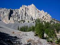
walls". The tarn lake at 9870 is a prominent landmark, as is the dramatic
twin towers above this area. Follow the slope north contouring an obvious
drainage line until your on the southwest ridge proper. Follow this to below the
uppermost limestone band and carefully traverse an exposed ledge of loose rock
and/or snow over a giant drop-off on the northwest side. The true summit
is just north of this crux. Notice a natural limestone arch underneath the south
summit- look through it to view the peaks to the south!
Conditions and Season
Standard climbing season is April through November Conditions may vary greatly. There are periods of very dry and cold weather in the winter.
Nearby Mackay, Idaho Climate Data:
| Jan | Feb | Mar | Apr | May | Jun | Jul | Aug | Sep | Oct | Nov | Dec | Annual | |
| Average Max. Temperature (F) | 29.2 | 34.2 | 43.0 | 55.2 | 65.2 | 74.1 | 84.1 | 82.7 | 73.3 | 60.1 | 42.1 | 31.3 | 56.2 |
| Average Min. Temperature (F) | 5.6 | 10.1 | 18.9 | 28.1 | 35.9 | 42.3 | 48.4 | 46.3 | 38.3 | 30.0 | 18.7 | 8.9 | 27.6 |
| Average Total Precipitation (in.) | 0.78 | 0.61 | 0.61 | 0.68 | 1.09 | 1.34 | 0.93 | 0.80 | 0.67 | 0.57 | 0.59 | 0.78 | 9.43 |
| Average Total SnowFall (in.) | 7.5 | 5.9 | 2.4 | 0.5 | 0.1 | 0.0 | 0.0 | 0.0 | 0.1 | 0.2 | 2.0 | 7.3 | 26.1 |
| Average Snow Depth (in.) | 5 | 4 | 1 | 0 | 0 | 0 | 0 | 0 | 0 | 0 | 0 | 3 | 1 |
For general comparison, the Lost River Valley is much drier (climatologically a desert) in the winter than some of the ranges to the west in Idaho. Yet in the summer, the Lost River Valley receives more precipitation. Periods of dry, cold, and windy weather may lend itself for opportunities to climb nearly year round.

Salmon-Challis National Forest Info
http://www.fs.fed.us/r4/sc/lostriver/maptravelplanaerialphotos.shtml
National Weather Service Current Forecast for Mackay: