
|
|
Mountain/Rock |
|---|---|
|
|
34.88920°N / 111.7516°W |
|
|
Coconino |
|
|
Spring |
|
|
5362 ft / 1634 m |
|
|
Overview
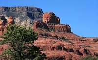
This massive sandstone formation looms above uptown Sedona and the mouth of Oak Creek Canyon. Named by Abraham James in 1880 because of it's boat like shape. Although many believe it resembles more of a submarine, that distinction belongs to a rock formation in the Broken Arrow area. Steamboat has two "decks", the first encountered is very long and level and a relief after the initial scramble. The second, or as I call it the "bridge deck", is harder more resistant limestone (Fort Apache formation) that protects the softer sandstone (Bell Rock formation) underneath. Vertical gain of this hike to "bridge deck" approx. 800 feet.
I have hiked/scrambled many formations in this area over the last 35 years and this is one of my favorites. The views are stunning and the scramble is truly enjoyable.
The actual last 100 feet or so of the summit is rarely climbed.
Getting There

From Flagstaff take State Route 89A south approx. 27 miles through Oak Creek Canyon (beautiful drive) to Midgley Bridge and park in the area on the right just before the bridge itself. From Phoenix take I-17 north approx. 110 miles to State Route 179. Go north on 179 to the junction with 89A and go north (right) through uptown Sedona (tourist mecca), cross Midgley Bridge and park in the area on the left. Parking can be a problem as this is a starting point for several trails as well as viewing the 1939 bridge itself. There are other places to park off 89a south of the bridge but there is no pedestrian path to cross the bridge. DO NOT walk across this span! At the parking area, go west and follow the wide old road bed which becomes the Wilson Canyon Trail. Hike past the pre-1939 bridge remains and come to a junction in the trails. The Jim Thompson trail is marked and forks to the left. Take this trail uphill until it widens and levels out. As the trail begins a gradual downhill and left bend, look for a trail to the right with dead wood blocking it from mountain bikes. Follow this trail up the north side of Steamboat watching for rock cairns along the way. There are many possible ways up this section but the cairns mark the best way for most hikers. Once up on the first "deck", enjoy the stroll and the great views. Continue south towards the second "deck". A loose talus slope presents itself to the right. Follow this up the slope to the limestone formation. There are several ways up but only two for most of us. Use your route finding skills and always remember that you must come down what you climb up! Once on the limestone "bridge deck" one can walk a level course from the north to the south. The views are superb from all along with the southern edge being the most dramatic. If you get this far only to remember that your camera is in your car, I PITY YOU! There is evidence enough that people do hike up here regularly (footprints, etc.) but thankfully I saw no litter whatsoever. It goes without saying (so why am I saying it?) pack it in, pack it out.
Red Tape

As with most hikes in the area, it can be done year round and is very hot in summer months. Prepare your hike accordingly.
This hike is in the Secret Mountain Wilderness and a Red Rock Pass is required. Here is a link with info on the passes.
Red Rock Passes
Camping
There are a few very nice campgrounds in Oak Creek Canyon as well as fine lodging in Sedona as well. Here are links to info on both.
Camping:sedona campgrounds
Lodging:cabins and cottages
External Links
General info about Sedona/Oak Creek Canyon:general info
Weather
Weather Channel info:sedona weather
Extra info
For those bold enough to want to try the true summit, here is a link with some helpfull info:
mountainproject.com