
-
 5004 Hits
-
 87.76% Score
-
 25 Votes
|
|
Route |
|---|---|
|
|
42.14100°N / 111.565°W |
|
|
Hiking, Scrambling |
|
|
Spring, Summer, Fall |
|
|
Most of a day |
|
|
Class 2 |
|
|
Overview
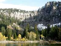
This route traverses the three summits of Saint Charles Mountain. The eastern summit is the highpoint, the central summit is where the impressive cliffs above Bloomington Lake are located, and the west summit is a pyramid shaped peak. The limestone cliffs above the Bloomington Lake are 600 feet high. There is an arch located on the side of one of the walls.
Northwest of Bloomington Lake is an unnamed lake. This is the shallow lake that you first get to. Bloomington Lake is farther in distance right below the cirque. Before or after you climb Saint Charles Mountain you should take the short hike to Bloomington Lake. Many people visit the lake each year but Saint Charles Mountain is not climbed as often.
Approach Option #1 - Bloomington Lake Trailhead
 West Summit
Bloomington Lake Trailhead:
The city of Bloomington is located near Bear Lake north of the city of Saint Charles. From Bloomington turn west into Bloomington Canyon which is well signed. Drive down this road for about 8 miles. You will get to a junction for the south and middle fork of the canyon. Take the south fork and drive up this wash boarded road. A high clearance vehicle is recommended. There will be a side road to Telegraph Flat. Keep driving on the main road to the trailhead.
The trail to the lake is about 0.5 miles long. The first lake has a trail that goes around it. The West Summit of the mountain will be above the lake and this is where the summit traverse begins. Bloomington Lake is located farther in distance and is right below the cirque of cliffs. This approach is the shortest to the peak.
Approach Option #2 - North Fork of Saint Charles Canyon
 Bloomington Lake Cirque
 Bloomington Lake Cirque
North Fork of Saint Charles Canyon:
The city of Saint Charles is located at the northwestern end of Bear Lake in Southeast Idaho. You can access this area from Highway 89 that goes to the city of Saint Charles. Drive 0.5 miles north of the city to a sign saying Minnetonka Cave. Turn west down this paved road. Drive for 7 miles until you go past the Big Creek Group Area sign. Turn right on the first dirt road after that. There is a sign for the Middle Fork of Saint Charles Canyon. Drive 0.2 miles farther to a large parking area at the trailhead.
At the North Fork of Saint Charles Canyon trailhead, a few large boulders mark the beginning of the trail at the northwest end of the parking area. The trail is very wide for the first two miles of the hike. It travels through a forest of firs and aspens. Willows and cottonwood tress are located along the creek. You will be walking along the creek for much of the way. During spring runoff, the water may be running over part of the trail. Expect to get your feet a little wet.
After hiking for 1.2 miles, the trail crosses the creek again over to the south side. There will be foot bridges at some of these crossings. There is a trail junction 2 miles from the trailhead. The trail on the left goes up Snowslide Canyon. During the descent you can take the Snowslide Canyon trail as an alternative but longer route down. The trail on the right goes up the North Fork of Saint Charles Canyon. Take the trail that goes right at the junction. At 3.2 miles the trail crosses the creek and continues on the right side of it for another mile.
When the trail reaches the head of the canyon is starts to gain elevation and climb. At 4.5 miles the trail reaches a junction near the top of the ridge. This is where is meets the Highline Trail. You will want to go on the trail heading north. After 0.5 mile, there is a side trail that goes right. The trail goes down hill and becomes a jeep trail before getting to the Bloomington Lake parking area. On summer weekends you will probably see several vehicles parked here.
Summit Traverse
The climb up the mountain starts just above the Bloomington Lake parking area. The traverse is described going west to east. Distance from the trailhead to the summit via the North Fork of Saint Charles Canyon is 8 miles and Elevation Gain is 2,475 feet. If you are driving to and starting from Bloomington Lake trailhead it will be a much shorter hike.
 West Summit
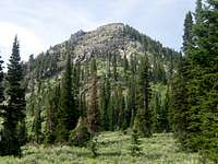 West Summit
 Central Summit
West Summit - (9,195 feet)
 Central Summit
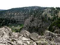 East Summit
 East Summit
There is a shallow lake located northwest of Bloomington Lake. You'll want to go toward the lake but not past it. From here you will see the West Summit to the southeast. Hike toward the base of the mountain through the sagebrush and bushes. The scrambling is steep but is a little easier if you move farther to the right up the face. This section has large refrigerator size boulders. The rocks are grey and white in color and near the top it becomes darker colored cliff bands and boulders. On the summit was a nicely built cairn. You should be able to see the Bannock Range to the west.
Central Summit - (9,158 feet)
From the West Summit descend down the east face of the mountain. You will lose quite a bit of elevation in the process. There is a saddle between the west summit and central summit. You will pass above the top of the several steep gullies on the left that can be climbed up to the ridge. Ascend the forested ridge up to the summit. There is an even better viewpoint located farther to the northeast. This is the point that is located right above Bloomington Lake. This is what most people think is the highest summit of the mountain. The rugged ridge above the lake can be seen heading north from here in a long row of cliff bands.
East Summit - (Saint Charles Highpoint) - (9,245 feet)
Continue from the Central Summit and hike along the ridge. You will pass above the top of the Bloomington Lake gullies on the left that can be climbed up to the ridge. There was a small game trail to the right side of the ridge. It is a gradual climb with only few trees blocking the way. The highest summit is located on a flat plateau. You will be able to see the northern end of Bear Lake to the east. The view to the west includes the other two summits and views of Bloomington and Paris Peak. You won’t be able to see Bloomington Lake because it is blocked by a long ridge. There was a small pile of rocks on the summit but no register or benchmark. If you have time, forested Peak 9276, to the east, may also be added to the hike. That peak is over thirty feet higher but appears less interesting than Saint Charles Mountain.
Descent
Here are some Saint Charles Mountain descent options:
1) Standard Descent
 Central Summit
The standard way down the mountain is to reverse the route over all three summits. This is the longest descent route.
2) Bloomington Lake Gullies Descent
Hike back along the ridge to the Central Summit. Continue west until you are above the Bloomington Lake Gullies. When the gullies are dry it is a steep talus descent down to the lake. When they are filled with ice it is not recommended that you descend this route. This is the fastest way down the mountain.
3) East Summit West Face Descent
This is the route I used to descend the mountain. On the East Summit hike north along the ridge for about 0.3 mile. Start heading down the west face when comfortable. The steep face is covered in grass, dirt, and rocks. Use game trails whenever possible. There are some cliff bands on the face that you will want to avoid. As you start getting lower, you will see a large basin below you. It is located in a hidden canyon below the East Summit and the ridge that separates Bloomington Lake. Once in the canyon, start hiking north. You will want to hike around the ridge that is blocking your way to the west. After you hike around the ridge, start heading back south. Use the West Summit as a landmark to finding Limekiln Lake which is located below. There will be some bushwhacking involved in getting to the lake. Once there, you can follow the trail back to Bloomington Lake trailhead.
Essential Gear
You will need basic day hiking gear, food, and water. Bring boots that can handle off trail hiking. A topomap is helpful and GPS is optional. There is abundant wildlife in the area so I recommend filtering all water.
Early or late in the season, you may need an ice ax and crampons. This would be April through May and October through November.