
-
 19093 Hits
-
 94.82% Score
-
 49 Votes
|
|
Mountain/Rock |
|---|---|
|
|
42.14100°N / 111.565°W |
|
|
Bear Lake |
|
|
Hiking, Mountaineering |
|
|
Spring, Summer, Fall |
|
|
9245 ft / 2818 m |
|
|
Overview
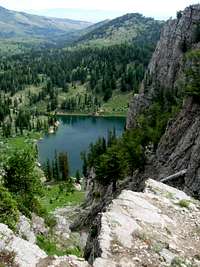 Bloomington Lake
Saint Charles Mountain is located in the Bear River Mountains. It is one of the most rugged peaks in the range. The mountain sits on the ridge that divides two forks including the south fork of Bloomington Canyon and the north fork of Saint Charles Canyon. The mountain is composed of several different types of rock including limestone, dolomite, shale, and quartzite. Several of these rocks have fossils and mineral intrusions embedded in them. There were strange layers of white and dark boulders located all over the area.
The mountain is across the canyon from Bloomington Peak which is located to the west and Paris Peak which is located to the north. It is surrounded by steep cliffs on its west face that form a barrier around Bloomington Lake. The lake is one of the most beautiful in the range. The majority of the lake is between 35 to 60 feet deep. Sonar has determined the deepest depth to be over 150 feet depending on the exact area. This gives the lake its dark blue color. It is a popular place to visit in southeast Idaho so you will probably see people on summer weekends. Some go swimming in the lake but learn quickly that the water is very cold.
Saint Charles Mountain has three summits. The eastern summit is the highpoint, the central summit is where the impressive cliffs above Bloomington Lake are located, and the west summit is a pyramid shaped peak. The west summit had a nice cairn on top while the other two had a small pile of rocks. There was no register or benchmark on the highpoint. I got the impression that the mountain was not climbed often. There were a few game trails and I saw several deer while climbing the mountain. The view from the summit includes the northern end of Cache Valley, Bear Lake Valley, the Bannock Range, and the mountains in the Idaho portion of Bear River Range.
The Bear River Range is a long chain of mountains that form the northern extension of the Wasatch Range. They run in a north to south direction from Soda Springs, Idaho to Logan, Utah. This is a great area with many mountains and lakes. There are only a few mountains that are climbed often including Naomi Peak, the highest in the range. The highest peaks are over 9,000 feet in elevation. They vary from rolling hills to summits surrounding by cliffs. Standard routes are usually no harder than class 2 but more difficult routes can also be found. Some of the most interesting peaks remain unnamed and are seldom climbed.
The mountain is unofficially named for its proximity to the city of Saint Charles. The city, the mountain, and canyon were named after Charles C. Rich. His full name was Charles Coulson Rich and he was born in Kentucky. His family then moved to Illinois in 1831. He had heard about the LDS church and decided to become a Mormon. Charles C. Rich helped organize the Mormons departure from Nauvoo, Illinois to Utah. He followed Brigham Young's Pioneer Company into Salt Lake Valley in October 1847. The next year he moved his family to Centerville, Utah. He then accepted the call to colonize the Bear Lake region. In 1863, Rich led his party from Franklin, Idaho into Bear Lake Valley, and settled Paris, Idaho. Brigham Young would later name Rich County in Utah after him.
Getting There
Saint Charles Canyon Trailhead:
 Central Summit
The city of Saint Charles is located on the east side of the Bear River Range at the north end of Bear Lake. Access is from Highway 89 toward the city of Saint Charles. Drive 0.5 miles north of the city to a sign saying Minnetonka Cave. Turn west down this paved road. Drive for 7 miles until you go past the Big Creek Group Area sign. Turn right on the first dirt road after that. There is a sign for the Middle Fork of Saint Charles Canyon. Drive 0.2 miles farther to a large parking area where the trailhead for the North Fork of Saint Charles Canyon is located.
The North Fork of Saint Charles Canyon is the most scenic hike up the mountain. This is the longest route but the elevation gain is gradual. The approach to the mountain is described on the route page. There are two alternative routes described on the main page. They are from Willow Flat or Bloomington Lake trailhead. All routes converge at Bloomington Lake trailhead.
Willow Flat Trailhead:
This trailhead is located on the west side of the Bear River Range. Willow Flat Campground is 3 miles south of Preston, Idaho on Highway 91. Turn east on the Cub River Road (#406). There will be a Y intersection 3 miles inside the Cache National Forest boundary. Road 406 and 407 intersect at the Y. Take the right fork which is still road 406. Willow Flat Campground is located 1.5 miles from the intersection.
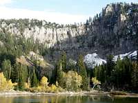 Bloomington Lake Cirque
A hiking trail leaves the campground and goes east for 2 miles to where is intersects the High Line Trail. At the junction, take the trail that goes north for 0.7 miles and then descends down to the Bloomington Lake trailhead. A wide trail climbs up from the trailhead and goes toward Bloomington Lake.
Bloomington Lake Trailhead:
The city of Bloomington is located near Bear Lake north of the city of Saint Charles. From Bloomington turn west into Bloomington Canyon which is well signed. Drive down this road for about 8 miles. You will get to a junction for the south and middle fork of the canyon. Take the south fork and drive up this wash boarded road. A high clearance vehicle is recommended. There will be a side road that goes to Telegraph Flat. Keep driving on the main road to the trailhead.
The trail to the lake is about 0.5 miles long. The first lake has a trail that goes around it. Bloomington Lake is located farther in distance and is right below the cirque of cliffs.
Routes Overview
All of the following routes start from Bloomington Lake Trail. There are three ways to get there which are mentioned above. The Willow Flat Trailhead is located on the west side of the range. The Saint Charles Canyon North Fork Trailhead and Bloomington Lake Trailhead are located on the east side of the range.
Summit Traverse
 Bloomington Lake Gullies
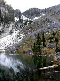
This route traverses the three summits of Saint Charles Mountain. The eastern summit is the highpoint, the central summit is where the impressive cliffs above Bloomington Lake are located, and the west summit is a pyramid shaped peak. This is not a difficult traverse but offers great views of the surrounding area. The limestone cliffs above the Bloomington Lake are 600 feet high. There is an arch located on the side of one of the walls. There is usually plenty of wildlife in this area as well. Northwest of Bloomington Lake is an unnamed lake. People who visit the area sometimes mistake it for Bloomington Lake which is farther below the cirque.
Bloomington Lake Gullies
This is the shortest route up the mountain. Walk up the trail to the first lake. It has a trail that goes all the way around it. Bloomington Lake is located below the steep cirque of cliffs. The Bloomington Lake Gullies rise directly out of the lake. You will have to walk around to the other side to get to the base of the route. The gullies are located west of the Central Summit. It is a straight forward climb up steep talus. This route also makes a nice spring snow climb during April and May. You will need an ice ax and crampons. Snow usually last into July on the shaded part of the mountain. The book Idaho: A Climbers Guide, by Tom Lopez, says that the gullies route borders on class 3 scrambling.
When to Climb
 Central Summit
 East Summit
The summer months are the typical climbing season. In spring and early summer, mosquitoes can be a problem especially near the lakes. The fall season is my favorite time to be in the Bear River Range because of the changing colors. The mountain would be difficult to climb in winter. Roads will be covered in snow and the long distances would keep most people away. It would involve at least 10 miles of skiing or snowshoeing.
The mountain can be climbed from the North Fork of Saint Charles Canyon or Willow Flat when access roads are dry. This is from April though October. There will be considerable snow in the higher elevations during spring. This is one of the best times to climb the mountain since there will be few people in the area.
The South Fork of Bloomington Canyon is a dirt road that is wash boarded and is not recommended when wet. So the season for driving to the Bloomington Lake trailhead would be from mid-May through mid-October. A high clearance vehicle is recommended but I have seen some cars make it to the trailhead.
Red Tape
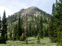
 Saint Charles Mountain
 West Summit
Saint Charles Mountain is located in Caribou-Targhee National Forest
There are no fees for climbing the mountain. No vehicles, including four-wheelers and motorcycles, are allowed beyond the Bloomington Lake trailhead. Horses are allowed on the trail. Group size is limited to 20 people.
Caribou-Targhee National Forest Headquarters Office is located in Idaho Falls, Idaho at 1405 Hollipark Drive 83401. Phone (208) 524-7500.
The Montpelier Ranger District Office is located in Montpelier, Idaho at 322 North 4th Street 83254. Phone (208) 847-0375.
Camping
 West Summit
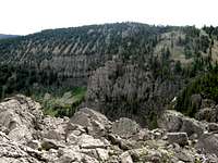 East Summit
There are several campgrounds located in the Bear River Range. Willow Flat is the best place to camp if you are hiking in from the west side of the range. Access is 3 miles south of Preston, Idaho on Highway 91. Turn east on the Cub River Road (#406). There are two other campgrounds located in the area. They include Cub River Guard Station which has a cabin and Albert Moser Campground which has 9 sites.
On the east side of the range are many canyons that have campgrounds. Drive on US 89 near Bear Lake to the turnoff for Saint Charles Canyon Forest Road 412. Saint Charles Campground is located at 3 miles, Porcupine Campground is located at 4 miles, and Cloverleaf Campground is located at 7 miles.
Backcountry camping is allowed in undeveloped sites. Camping is free in these areas as long as you select a site outside a developed campground. Camp 200 feet away from any road, trail, or water source. The camping limit in one spot is 16 days.
 Saint Charles Mountain
Campground Reservations:
Willow Flat Campground - 6,300 feet elevation. 48 single campsites. Open May 25 through October 30.
Saint Charles Campground - 6,100 feet elevation. 1 Group campsite. Open May 24 through September 8.
Porcupine Campground - 6,800 feet elevation. 6 single campsites. Open May 24 through September 8.
Cloverleaf Campground - 7,100 feet elevation. 18 single campsites. Open May 24 through September 8.
Books
Idaho: A Climbers Guide: Climbs, Scrambles, and Hikes - By Tom Lopez. Has info on the Idaho portion of the Bear River Range.