
|
|
Mountain/Rock |
|---|---|
|
|
15.13250°N / 92.1086°W |
|
|
13484 ft / 4110 m |
|
|
Overview
Tacana is the second highest peak in Central America, and sits on the border of Mexico and Guatemala. It is also know as the Soconusco Volcano in some regions of Mexico. From the summit you can see all the highest volcanoes in Guatemala and many others in Mexico. It is also is possible to see the Pacific Ocean. Tacana is considered to be an active volcano, and has a crater on of Mexican side, with some fumes. It was last active between January 1986 and February 1988.The volcano can be climbed from either Guatemala or Mexico. The Guatemala side of the volcano is a shorter climb, but the trailhead is harder to reach and is a very long bus ride into a very remote part of the country. The Mexican side of Tacana is much easier to get to as its near some larger towns, but it is a longer hike from that side and usually takes two days, sometimes more.
 Volcán Tacaná as seen from the slopes of Volcán Tajumulco.
Getting There
From the Guatemala side, and Guatamala City, take the bus to San Marcos, once there, you need to take the road to San Jose Ojetenam, and after of reach that villiage, take the bus to Sibinal, which is where the trail starts. Sporatic bus service is available for the long 350 km ride.From the Mexican side, make your way by bus to Tapachula. From there, take the once every half hour bus to Cacahatan. From there, another once every half hour bus heads the 23 kms to Union Juarez. This is as far as public transportation goes. From the main plaza in Union Juarez, walk (if you're lucky, you may get a lift) north along the paved cobblestone road to the villiage of Cordova, and then continue to Taliquan. From Taliquan, find the stone monument that marks the trail.

Routes Overview
There are at least two main routes to the summit of Tacana. The trailhead on the Mexican side is easier to get to, and is the route I used.The route on the Mexican side is known as La Linea.
Breifly put: From Taliquan, find the stone monument that marks the trail. From the stone monument, the well used trail heads along either side of the Mexico/Guatamala border. The border is easy to identify as its marked with a highly visible clear cut line through the forest, and refered to as La Linea (The Line). This is an interesting walk, and it passes through several tiny villiages and farms that can only be reached on foot. There is a cliff to pass and quite a few confusing trails until you reach a very good path to the summit of Tacana. See the route page for more details.
SP member mmcguigan adds the following information about the Guatemalan side of the mountain (2008):
We just finished climbing Tacana from the Guatemalan side. To get to the base of the volcano took about 8 hours (four hour bus ride, 3.5 hour ride to town, and about 45 minutes of hair raising adventure along a number of narrow ridges where no road should be). I strongly recommend a local guide. The trail is very well marked and passes a couple of houses and ranches along the way. Bring plenty of snacks and water as there is no place to purchase them. The climb up is great because of the wonderful variety of landscapes you encounter along the way. I also really enjoyed seeing the peak jutting up from inside the cone - a mountain on top of a mountain!
Via Guatemala Route Page
 Slopes of Tacana from near the trailhead.
Red Tape
A guide is not required, but can prove useful. Rumor has it that landmines exist on the mountain on the Guatamala side, so use extreme caution, and avoid anything that looks unusual!!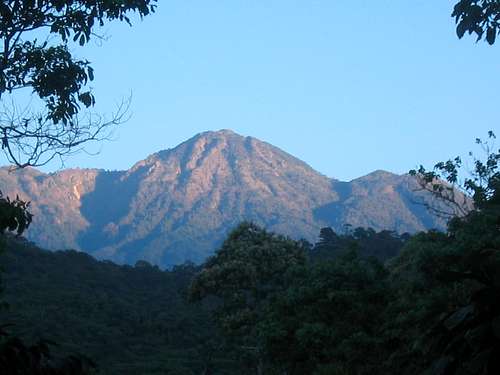 Some of the slopes near the trailhead on the Mexico side. Rumor has it that there still may be some old landmines in the area.
When To Climb
December through April is the dry season, and the best time to climb the volcano.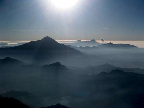
Camping
There are many places to camp on the mountain. The most popular campsites on the Guatamala side are known as Hacienditas, then Potreros, and then at Laguna Seca which is located in an old crater.There are several campsites along the trail on the Mexican side as well. Just make sure not to camp near one of the farms without permission. The most spectacular site in on the summit itself, but it can be very cold there so be prepared. There is, or at least was some stagnant water in the crater, but I highly recommend hauling water up from the springs.
Annual Holy Week Climb
It is a popular tradition to make a mountaneering meeting on the Tacana summit's during Holy Week (Easter), which is during the week of the first full moon after the Spring Solstice, usually the week of full Moon after March 21. The volcano is climbed for mountaineers from all over Guatemala / El Salvador and Mexico.Updates and More Information
This page was written almost 12 years after I did the actual climb, and much of it from memory. Please post any updates to the page, and I will integrate them into the text.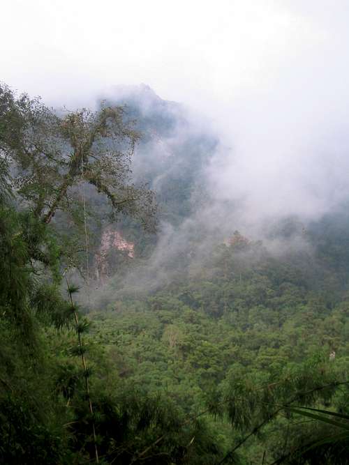
Credits
Some updates are from my climbing partner, Mike Kelsey who wrote the highly recommended Climbers and Hikers Guide to the Worlds Mountains. Mike climbed this peak in January 1994.I climbed the peak in January 1993.
Mountain Conditions
The closest weather link is in Tuichan at 2900 meters elevation. Expect cooler and wetter conditions in the mountains.Tuichan Weather Forecast
 Tacana in the clouds.
AnniinaH6C9trXd - Jan 6, 2020 3:29 am - Hasn't voted
Getting to Talquian from Guatemala - accommodation in TalquianI did this climb solo in January 2019 - there was almost no one else. Coming from Guatemala, I would recommend crossing at Talisman (or Tecun Uman), and without going to Tapachula taking a bus to Cacahuatan, from where you can find shared taxis and buses to Talquian. In Talquian the president of Ecotourism is called José, he has a place called "Casa José Tacaná". He is your man to go in Talquian - for accommodation, guide serivices, tips etc.