
|
|
Mountain/Rock |
|---|---|
|
|
47.42000°N / 13.05000°E |
|
|
Hiking, Mountaineering, Via Ferrata |
|
|
Summer, Fall |
|
|
7083 ft / 2159 m |
|
|
Overview

Taghaube is a beautiful mountain next to Hochkönig with a view to Hochkönig with its summit cross, to Grandlsitz and Hochseiler a few metres in the North, Ankogel group in the South and Glockner group in the Southwest with Großglockner and Grosses Wiesbachhorn as spectacular rises and also Grossvenediger in the WSW.
There is a good and fast access to the mountain and the near Erich hut is a nice base for climbing Taghaube and the other mountains in this area.
In some guide books a route from Taghaube to Grandlspitz is described with a fixed rope. This route doesn´t exist any more because some accidents happened as climbers climbed the wrong way (rock difficulty III/IV). If you want to make the traverse Taghaube-Grandlspitz you should start at Grandlspitz and traverse to Taghaube as this route is set up as a one-way route in this direction. So the last difficult part to Taghaube summit is much easier (obvious route) than descending from Taghaube (route not visible).
Getting There
From Tauernautobahn via Bischofshofen to Mühlbach, from Mühlbach towards Dienten. Before you reach Dienten there is the Dientener Sattel on the right side with some parking possibilities.From Zell am See to Dienten (30 minutes). From Dienten in 10 minutes to Dientener Sattel (direction to Mühlbach, the Sattel is on the left side, sign: Dientener Sattel, Parkplatz Erichhütte).
From the parking place you hike on a good trail to Erich hut (signs) in 40 minutes.
From Erich hut follow the route No. 33 (red sign). After 45 minutes you have the possibility to go left to Hochkönig or go right to Taghaube. Follow the sign Taghaube and hike to the right side. The trail is getting steeper and after passing some mountain pines you reach the rocky part of the normal ascent. The route is marked with a red sign on some rocks. The last 30 minutes gets exposed and you have to be careful. For a difficult and very exposed passage there is a fixed ladder. The last part to the summit with the summit cross you have rock difficulty I. Be careful when the rocks are wet – some rocks are greasy.
The first part of the ascent is a nice hike on a wonderful trail with great wild mountain flowers. The last rocky part is exposed with rock difficulty I.
 First part of the ascent First part of the ascent |  Passing the mountain pines Passing the mountain pines | 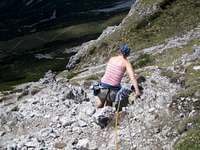 Last rocky part (I) before the summit Last rocky part (I) before the summit |
|---|
Red Tape
No red tape thereCamping
In Dienten and Mühlbach is no camping place.Camping places are in:
Camping Kastenhof - 5600 St. Johann im Pongau, Kastenhofweg 6
Camping Hirschenwirt - 5600 St. Johann im Pongau, Bundesstrasse 1
Campingplatz Passrucker - 5541 Altenmarkt, Zauchenseestrasse 341
Sonnenterrassen-Camping St. Veit - 5620 St. Veit, Bichlwirt 12
Camping Aschau - 5612 Hüttschlag, Karteis 24
External Links
Link Hochkönig areaWebcam
dmiki - Aug 15, 2011 12:31 pm - Voted 10/10
coordinates for the summitI think they should be Lat=47.40358, Lon=13.05759