
|
|
Mountain/Rock |
|---|---|
|
|
47.59392°N / 13.06631°E |
|
|
8274 ft / 2522 m |
|
|
Overview
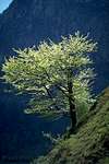
The "Hoher Goell" (or in german "Hoher Göll") is a huge and massive mountain, it's summit towering almost 2000 meters above the town of Berchtesgaden, east of the Königsee, opposite of "Watzmann".It is a very popular "sight-seeing summit" and you have a great view onto Dachstein in the East and Watzmann in the West.
"Hoher Goell" offers a wide variety of routes onto the summit, ranging from a mere hike for experienced hikers (UIAA Grade I), over a via ferrata up to a UIAA Grade VIII climb in the West face!
Very popular and worthwhile is the traverse of the summit from north to south - either from "Kehlsteinhaus" via "Mannlgrat" or from "Purtschellerhaus" up to the summit and down to "Stahl-Haus".
 |  |  |  |  |
Routes Overview
As mentioned before there are quite a lot of different routes of all difficulties onto "Hoher Goell".Here is just a short overview on the most popular and most worthwhile routes:
"Salzburger Steig"
UIAA Grade I. From the north. Starting point is the alpine hut "Purtschellerhaus" (see below). About 2,5 hours from the hut to the summit. Marked with red spots.
In spring, early summer and autumn there can be a lot of snow and even ice in the route!
From Torrenerjoch
UIAA Grade I. From the south. Starting point is the alpine hut "Stahlhaus" (see below). About 4 hours from the hut to the summit. Marked with red spots.
Although most of the route is southexposed and therefore even in spring and autumn without snow you have to cross a north facing slope and there can be snow almost the whole year round!
Mannlgrat
UIAA Grade I. From the northwest. Staring point is the "Kehlsteinhaus". About 3 hours from "Kehlsteinhaus" to the summit. It's a kind af via ferrata with wire ropes and marked with red spots.
Through the Alpeltal
UIAA Grade I. From the west. Starting point is the road to Hinterbrand. It's seldom used for ascents but it's a kind of emergency descent in case of bad weather!
West ridge
UIAA Grade IV. Starting point is "Scharitzkehlalm". Very long climb - up to 8 hours!
West face
There are several climbing routes in the west face of "Hoher Goell", ranging from UIAA Grade III ("Alte Westwand") to UIAA Grade VIII ("Trichterpfeiler")!
 |  |  |  |  |
Getting There
By car:On german Autobahn A8 to the southeasternmost corner of Bavaria, to "Bad Reichenhall" and on road B20 further on to Berchtesgaden.
By public transport:
By train via "Bad Reichenhall" or "Salzburg" to Berchtesgaden. Berchtesgaden and the surrounding area has a very good public bus system and you can reach almost all of the starting points of the routes by bus!
 |  |  |  |  |
Red Tape
No restrictionsThe road from Obersalzberg up to Enzianhuette and Ahornkaser (beginning of the paths to "Purtschellerhaus") and further on - the so-called "Rossfeldstrasse" - is a toll road. They charge 5 Euro for a normal car during daytime. The gate is attended until about 8 pm (20 Uhr) and afterwards the barrier will be open!
When To Climb
You can climb "Hoher Goell" the whole year round, depending on weather conditions, snow conditions and your skills!Easiest time to climb "Hoher Goell" is in summer, from May to September, and thats also the time when the summit can be "crowded" on beautiful weekends!
In spring and autumn there can be a lot of snow in the routes, especially in the north facing parts of the ascent.
In winter, depending on the amount of snow already fallen, you can ascent "Hoher Goell" either by foot (maybe with crampons) or with skis - it's a popular ski touring target!
 |  |  |  |
Camping and other accommodation
There is a camping site south of Berchtesgaden, located on the road between the town and "Königsee".The "Purtschellerhaus" (1692 m) is located north of "Hoher Goell". It offers 72 sleeping accommodations and is open from mid-May to the end of October.
Tel.: 0049/(0)8652/2420
The "Carl-von-Stahl-Haus" or short "Stahl-Haus" (1736 m) is located south of "Hoher Goell". It offers 94 sleeping accommodations and is open the whole year round!
Tel.: 0049/(0)8652/2752
Fax: 0049/(0)8652/63940
 |  |
Mountain Condition
Unfortunately there is no webcam showing "Hoher Goell" itself.But to have a look at the weather and snow conditions on the "Goell massive" you can use the webcams of the Jennerbahn, south of Berchtesgaden. The summit of "Jenner" is located about 4 km southwest of the summit of "Hoher Goell".
 |  |  |  |
Guides and Maps
The following guide book and the map should be essential if you would like to do some hiking or climbing tours at "Hoher Goell" or other mountains in the Berchtesgadener Alpen, such as "Watzmann" or Hochkalter.H.Schöner, B.Kühnhauser
Alpenvereinsführer Berchtesgadener Alpen
Bergverlag Rudolf Rother, München, 1997
ISBN 3-7633-1127-0
Umgebungskarte 1:25 000
UK 25-1 Nationalpark Berchtesgaden
Bayrisches Landesvermessungsamt, München, 2001
ISBN 3-86038-093-1
 |  |
External Links
- Klettersteig Watzmann Hoher Göll - Klettersteige auf via-ferrata.de
Via-Ferrata.de - Das Klettersteigportal - Über 100 Touren
wuedesau - Jan 15, 2004 10:23 am - Voted 6/10
Untitled Commentreally good idea! never thought about it.
guenni - Jan 22, 2005 7:48 am - Voted 10/10
Untitled CommentThese are coordinates in degrees and minutes. After all the postings during the last two days with Michael Prittwitz and Gangolf Haub I think that coordinates in decimals (as used by SP) must be Lat 47'58 N and Lon13'06 E.
Günni
guenni - Jan 23, 2005 3:00 pm - Voted 10/10
Untitled CommentFor distances shown in SP it is important whether you write 12 degree 59 minutes (almost 13 degree) or 12'98 E, the same in decimals. I think a lot of not plausible distances in SP are caused by this error (SP actually shows the distance between Watzmann and Hochkalter as 22 miles!).
Vid Pogachnik - Aug 12, 2002 7:34 am - Voted 9/10
Untitled CommentA good idea is to leave bikes on Eckersattel, go down by car, park it and take a bus to Kehlstein. So you can climb Hoher Göll by the Mannlsteig and descend to the Purtscheller haus and Eckersattel.
wuedesau - Oct 27, 2003 8:55 am - Voted 6/10
Untitled CommentKuchl (route from town via Kuchler Skihütte and Dürrfeichtenalm to the Purtscheller Haus) and Golling (route from the Bluntau valley and the Stahl Haus) can be reached by the Austrian motorway A10, by train (train stations at Kuchl and Golling, trains every 30-60 minutes) and public bus.
Kuchl is also starting point for the spectacular Göll east face.
wuedesau - Oct 29, 2003 9:47 am - Voted 6/10
Untitled CommentLat.: 13°04´
Lon.:47°35´
wuedesau - Oct 31, 2003 4:07 am - Voted 6/10
Untitled Commentsee http://www.oebb.at/english/index1.html
wuedesau - Jan 15, 2004 10:23 am - Voted 6/10
Untitled Commentreally good idea! never thought about it.
wuedesau - Nov 22, 2004 8:06 am - Voted 6/10
Untitled CommentIt should be mentioned that especially its east side is quite impressive. It draws your attention from as far as 50km.
guenni - Jan 22, 2005 7:48 am - Voted 10/10
Untitled CommentThese are coordinates in degrees and minutes. After all the postings during the last two days with Michael Prittwitz and Gangolf Haub I think that coordinates in decimals (as used by SP) must be Lat 47'58 N and Lon13'06 E.
Günni
guenni - Jan 23, 2005 3:00 pm - Voted 10/10
Untitled CommentFor distances shown in SP it is important whether you write 12 degree 59 minutes (almost 13 degree) or 12'98 E, the same in decimals. I think a lot of not plausible distances in SP are caused by this error (SP actually shows the distance between Watzmann and Hochkalter as 22 miles!).