Page Type Page Type: Mountain/Rock
Location Lat/Lon: 47.46080°N / 12.90074°E
Activities Activities: Hiking, Mountaineering
Seasons Season: Spring, Summer, Fall
Additional Information Elevation: 8173 ft / 2491 m
Sign the Climber's Log

Overview

MitterhornMitterhorn summit


Standing high at the southern crest of Steinernes Meer / Berchtesgaden Alps, steep Mitterhorn, placed between Breithorn in the south, Ahlhorn in the north and Persailhorn in the west, is seldomly visited. This is due to a more remote location of this summit, showing steep slopes even to the north and being far from the connecting trails on the plateau of Steinernes Meer or from ascent trails onto the plateau.

The “Saalfeldener Höhenweg” between Riemannhaus and Peter Wiechenthaler Hütte, placed high above Saalfelden on the southern slopes of Steinernes Meer, traverses Mitterhorn. Thus Saalfeldener Höhenweg offers a good opportunity to summit this peak with its impressive views.


Getting There

Mitterhorn
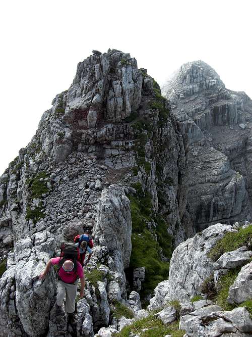
Climbing Mitterhorn from Breithorn


Arriving the valley trailheads


The main valley trailheads for Mitterhorn are Saalfelden or Maria Alm on the south side of Steinernes Meer.

You reach these neighbouring villages from


  • Kufstein / Inntal valley using road number 173 and 164

  • Traunstein or Berchtesgaden region in Germany by driving to Lofer on road number 178 and by going on on road number 311 to Saalfelden

  • Salzburg and Salzach valley by using highway A 8 (Tauernautobahn) to the exit Bischofshofen or Knoten Pongau and following road number 164 to Saalfelden

  • Zell am See and the southern regions by using road number 311 from Zell am See


  • You reach Saalfelden by train, too, from Kufstein - Wörgl - Kitzbühel or from Salzburg - Bischofshofen.
    For the schedules please refer to the ÖBB homepage.


    Saalfelden / Peter Wiechenthaler Hütte


    The Saalfelden trailhead is in the northern part of the town, called Bachwinkel. Follow the main road of Bachwinkel up to its end at the beginning of the woods, there are parking areas alongside the road. Bachwinkel is signposted from the road number 164 between Saalfelden center and Lofer.

    From the parking area follow the signposts to the hut via Mueßbacheck and Kreuzweg.


    Maria Alm / Riemannhaus


    From Maria Alm follow the road into Griesbachwinkl and Sandten valley. After some kilometers the road changes into a dirt road which climbs up steeply to the parking area at about 1200 m height.

    After the parking area the road is closed for public traffic. Follow the road up to the supply cableway valley station of Riemannhaus. Follow then the trail number 401 steeply up into the valley between Breithorn and Sommerstein / Schöneck up to Ramseider Scharte and to Riemannhaus. Spectacular views to the Sommerstein tower.

    At the last switchback of the dirtroad (about 1.500 m high) before you reach the cableway valley station there is a trail junction with signposts “Breithorn Südwandsteig”, another more difficult ascent route from Maria Alm.


    Adjacent mountain huts


    Riemannhaus as starting point can be reached, too, from the adjacent mountain huts:


  • from Kärlinger Haus / Funtensee via trail number 412 and Viehkogeltalsteig or number 413 via Baumgartl and Wunderquelle, one of the rare fountains on this karst plateau; trailhead to Kärlinger Haus is at the Sankt Bartholomä chapel / Königsee (to be reached only with a ferryboat from Berchtesgaden, see the schedule here)


  • from Ingolstädter Haus via trail number 401, Eichstätter Weg; trailhead for Ingolstädter Haus is Weißbach near Lofer; follow trail number 401 through the Dießbachtal to the hut


  • Peter Wiechenthaler Hütte as starting point can be reached, too, from the adjacent mountain huts:


  • from Kärlinger Haus / Funtensee via trail number 412 to Wegscheid, Weißbächlscharte


  • from Ingolstädter Haus via trail number 401, Eichstätter Weg to Wegscheid, then trail number 412 to Weißbächlscharte and to the hut.


  • Red Tape

    MitterhornMitterhorn and the connecting ridge as seen from Breithorn


    Mitterhorn is not part of the Nationalpark Berchtesgaden.

    There are no special restrictions as far as I know.

    Main Routes Overview

    MitterhornMitterhorn summit as seen from the traverse to Persailhorn


    Remember: Mitterhorn can only be reached by traversing another summit:

  • Saalfelden trailhead - Peter Wiechenthaler Haus - Persailhorn - Mitterhorn (part of the Saalfeldener Höhenweg)


  • Maria Alm trailhead - Riemannhaus - Breithorn - Mitterhorn (part of the Saalfeldener Höhenweg) or


  • Maria Alm trailhead - Südwandsteig to Breithorn (up to UIAA grade III) - Mitterhorn (part of the Saalfeldener Höhenweg)


  • Ingolstädter Haus - Weißbachscharte - Ahlhorn - Mitterhorn
    Kärlinger Haus / Funtensee - trails number 413 or Viehkogeltalsteig - Riemannhaus - Breithorn - Mitterhorn or


  • Kärlinger Haus / Funtensee - Weißbachscharte - Ahlhorn - Mitterhorn.


  • Thus you can combine those routes to different traverses, which are all very interesting, need some rock climbing skills and normally need 1 ½ to2 days and an overnight stay in one of the adjacent mountain huts.


    Saalfeldener HoehenwegMystic Mitterhorn
    MitterhornPeter-Wiechenthaler Hütte
    MitterhornSteinernes Meer plateau


    Accomodations

    MitterhornMitterhorn as seen from Persailhorn


    Accomodations of all kind - hotels, bed & breakfast, campgrounds - can be found in all major villages around Steinernes Meer:


  • Saalfelden>

  • Maria Alm

  • Lofer

  • Ramsau

  • Berchtesgaden


  • The following adjacent mountain huts offer overnight stays:


  • Riemannhaus

  • Peter - Wiechenthaler Hütte

  • Kärlinger Haus

  • Ingolstädter Haus

  • Wasseralm ( only overnight facilities, not a guarded hut)


  • Mountain Conditions & Gear

    MitterhornClimbing Mitterhorn summit


    Mountain Conditions


    Mitterhorn is mainly a summer and autumn summit.

    In combination with a ski hike to Breithorn, it may be climbed alongside from Breithorn in spring and best in connection with the ski traverse Große Reibn.

    In summer and autumn it is a more difficult hike via Breithorn / Südwandsteig, Ahlhorn traverse or Saalfeldener Höhenweg.

    Gear


    You need normal hiking gear with good boots. You need skills to master UIAA grade I - II in normally good rock.

    Helmet, hareness and Via Ferrata kit is recommended for the Saalfeldener Höhenweg (especially in connection with one of the Via Ferratas to Persailhorn).

    Bring enough to drink. As a karst plateau, Steinernes Meer nearly has no water for resupply.

    Maps


    The following topo maps are recommended:

    Alpenvereinskarte scale 1 : 25.000
    Blatt 10/1, Steinernes Meer, 2006

    Topografische Karte von Österreich, scale 1 : 50.000
    Blatt 124


    Children

    Children

    Children refers to the set of objects that logically fall under a given object. For example, the Aconcagua mountain page is a child of the 'Aconcagua Group' and the 'Seven Summits.' The Aconcagua mountain itself has many routes, photos, and trip reports as children.

    Parents 

    Parents

    Parents refers to a larger category under which an object falls. For example, theAconcagua mountain page has the 'Aconcagua Group' and the 'Seven Summits' asparents and is a parent itself to many routes, photos, and Trip Reports.

    Berchtesgaden AlpsMountains & Rocks