
|
|
Mountain/Rock |
|---|---|
|
|
42.80892°N / 19.33361°E |
|
|
Hiking, Mountaineering |
|
|
Spring, Summer, Fall, Winter |
|
|
6768 ft / 2063 m |
|
|
Most impressive peak of Moracke Planine
Tali (2063 m) is for sure the most impressive peak of MORAčKE PLANINE (Morača Mountains), which belongs to the group of most beautiful mountain ranges of Montenegro. Moračke Planine range is located in the central part of Montenegro. They extend east to northwest beginning at the Tara River canyon near Kolašin town, and then along the series of beautiful peaks, of mountains: Vučje, Umovi, Sto, Crni Vrh, Tali & Stožac.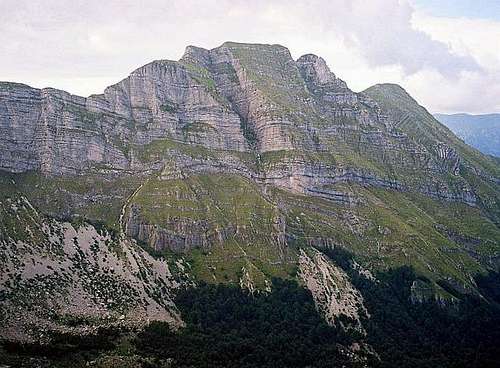 Impressive wall of Tali
Actually, Tali represent the mountain which is located between Gornja Morača (Upper Morača) and Donja Morača (Lower Morača). Its impressive 1660 m high vertical wall starts from Morača Canyon. The highest summit of Tali peak is Kule (2063 m), while the second highest summit is Ruda Glava (2020 m). One legend says that Tali got its name from the Ilirian word "Bad Toli" which means "High Hill", while other legend says that Tali got its name from the Turkish word "Talik" which means "Luck".
Tali is placed in the heart of many peaks, from SINJAJEVINA range to Kapa Moracka and Zebalaca, the highest peaks of MORAčKE PLANINE range. Naturally, Tali peak offer enjoyment in many impressive panoramas and views, and for sure an extraordinary enjoyment in amazing beauty of Moračke Planine range.
Route Info
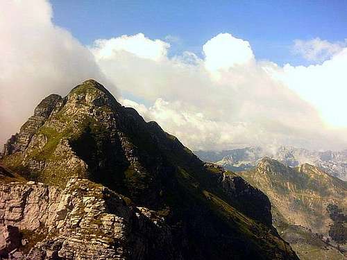
 Tali from SINJAJEVINA range
Mt TALI (Ruda Glava, 2020 m)
Coordinates: 42°48'48.0'' N ; 19°20'12.0'' E
Route: Gazela bridge & Osreci village (375 m) - Ropusnica katun (1472 m) - Korita (Kotla) katun (1485 m) - Ruda Glavica summit (2020 m)(T3): 3h
Height difference: 548 m
Lenght: 3 km
Duration: 3h
Trail: Unmarked
Registration book with stamp on Ruda Glavica (2020 m) summit
Getting There
 Tali peak (MORACKE PLANINE range)
By plane:
The closest airport is the one in Podgorica (70km away).
If you are planning to come via Serbia, you can use the Belgrade (Beograd) Airport in Beograd (Belgrade) city, capital of Serbia and Montenegro.
Information about flights and tickets on JAT Airways web page.
By train:
Beograd - Bar (Bar - Beograd) railway passes through Mojkovac and Kolasin. Then by car or taxi from Kolasin to Gornje Lipovo and Klisura (1189 m). In winter, there is a special ski-train for Kolasin from Bar and Podgorica. When you get off it, a ski bus will take you straight to the ski resort.
By Bus:
From Beograd (Belgrade):
Beograd (Belgrade) - Cacak - Uzice - Zlatibor - Nova Varos - Prijepolje - Bijelo Polje - Mojkovac - Kolasin
Then by car or taxi from Kolasin to Gornje Lipovo and Klisura (1189 m).
From Podgorica:
Podgorica - Kolasin
Then by car or taxi from Kolasin to Gornje Lipovo and Klisura (1189 m).
For the bus tickets and informations about but lines see Belgrade Bus Station page.
 Tali from Maganik
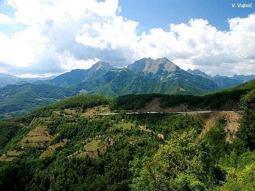
By car:
From Beograd (Belgrade):
Beograd (Belgrade) - Cacak - Uzice - Zlatibor - Nova Varos - Prijepolje - Bijelo Polje - Mojkovac - Kolasin - Gornje Lipovo - Klisura
From Podgorica:
Podgorica - Kolasin - Gornje Lipovo - Klisura (1189 m)
- Mojkovac - Kolasin road goes from the E side of the Moraca Mountains
- Mojkovac - Djurdjevica Tara road goes from the NE side of the Moraca Mountains
- Djurdjevica Tara - Savnik road start from the NW side of the Moraca Mountains (lower quality of the road)
- Savnik - Kolasin goes on the SW side of the Moraca Mountains
You should drive along the central Montenegrin highway, which connects the seaside to the towns: Cetinje - Podgorica - Kolasin - Mojkovac - Bijelo Polje; and goes on to Serbia (Belgrade city). This road is passable during most part of the year. It is closed only in case of abundant snowing or great rockslides. The landscape along the highway is particularly picturesque in the segment of the Moraca River Canyon between Podgorica and Kolasin. This part of the canyon is called “Platije”. The highway is built along the edge of the narrow canyon.
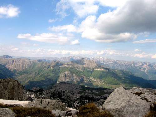
 Tali summit view
From Podgorica you can also take the village road for Kolasin. It goes across Lijeva Rijeka, Verusa and Matesevo. One part of it goes along the Tara River, which in this area is like a small, gentle and playful spring. The road is narrow, but in good condition. From the north, you will reach Kolašin if you take the highway that passes through Mojkovac. If you are coming from the east you should go across Andrijevica through Matesevo to arrive to Kolasin.
Camping
 Beautiful wall of Tali
 In the Moracke Planine (Moraca Mountains) area don't exist mountain huts, so you can freely use your private tents or bivouacs put them belowe the Tali and other peaks of the Moracke Planine range. Also, you can use empty shepherd's lodges for stay inside.
Mountain Conditions
The best meteo for Moracke Planine (Moraca Mountains) - is YUBC NET page. 5 days meteo, 4 times daily:Look meteo for the Kolasin town.
Red Tape
No fees or extra fees for entering the Moracke Planine (Moraca Mountains).No permits needed either.
Usual rules of behaviour for NP's do apply.