
|
|
Mountain/Rock |
|---|---|
|
|
19.22000°N / 98.43°W |
|
|
13389 ft / 4081 m |
|
|
Overview
Telapon is located about 20-25km NW of Iztaccihuatl and is part of the Sierra Occidental range in Mexico. Telapon is located in The Parque Nacional de Zoquiapan y Anexas a 19400 Ha park that is operated in conjunction with Izta-Popo Park. This mountain has some of the most beautiul forested sections in the entirety of Mexico, dotted with pines and scrub oak it is a tranquil, tranquil place.The summit is resplendent with Christian crosses and sadly littered with garbage... especially tin cans. It offers beautiful views of Ixta and Popo and for the purist who likes his/her mountain all to themselves this is it. Very few ever summit Telapon even those who live nearby and summit Tlaloc on a regular basis, so it is a great peak for kicking back and simply looking around at the world. The peaks that surround Telapon tend to detract from its significance... Tlaloc especially because of its religious signifcance to the Aztecs. Telapon is simply one of those high peaks that is surrounded by other more remarkable (in some ways) and renowned peaks. That is the main reason why it sees little traffic. Yet coupled with Tlaloc is a fantastic acclimatisation trip and a great place to get away from the crowds that one will encounter on many of the other Mexican volcanoes.
If one were seeking a more difficult ascent, climbing Telapon from the south is much more demanding. It is a much steeper climb with some class III and IV sections... though access requires one to leave the road and strike out through the trees on your own... If seeking to try this I would hope that you have more than adequate orienteering skills. Also on the western shoulder of Telapon are a series of boulders/slabs would provide a lot of fun for anyone wanting to climb around a little.
For variation climbing Telapon's NE shoulder provides one with fantastic views of the valley below, of the city of Rio Frio and the Mexican countryside. If its clear enough the views of Izta and Popo are excellent. Also towards the summit there are several areas of class II-III climbing that can be a lot of fun.
The area around Telapon's northern base is known as Manantiales which means 'spring' in Spanish. There is a spring which runs year round through the center of the valley. The forests are deep and cool... It is a vibrant place year round... green and full of life... which is a god send when the valley turns into a vast windblown dust bowl. At times like this Manantiales is a paradise.
Overall it is a very straightforward climb but well worth the hike up especially for training purposes and for those who simply love mountains, period.
 |  |  |  |  |
Getting There
Getting there is actually pretty straightforward. From Mexico City find your way to TAPO (the major bus terminal to all destinations in the south of Mexico).From TAPO find your way to Texcoco (a 45 minute bus ride) that will run about 14 pesos.Once you arrive in Texcoco ask for the bus to San Pablo. This is another 45 minute ride and your stop is the very last one. Once you get off the bus there is a road that snakes off up into the hills which you must follow until you encounter the aqueduct. Once you find the aqueduct follow it all the way until it goes underground. This will take anywhere from 4 to 6 hours (a distance of about 11km or 7 miles) depending on your degree of physical fitness as Manantiales is at about 3400m or 11000 feet. From there the summit of Telapon is clearly in sight.
The summit is essentially a hike up... taking about three hours round trip to get there. When I climbed it I skirted to the left of the 150-200 ft (45-60m) bluffs and stayed moving to the southeast very gradually. About an hour to 90 minutes later, after walking through some beautiful pine forests you will emerge on a sub summit.
From there there you will have to do one of two things... scramble down 40 m or so to the scree slope and follow that trail up to the top or follow the ridge you are on, although if you follow the ridge there is a gendarme that rises 30m or so and poses some difficulty to by-pass so keep that in mind... especially on the Mexico City side as it is very exposd and there is a steep long drop off if you were to slip. There is no marked trail but anyone remotely competent in mountainous terrain would have little difficulty. It is a great climb up with excellent views of Iztaccihuatl, La Malinche and Popo.
One can also ascend the peak from Rio Frio a small town to the NE, I have been told that the route is straight forward, but I have little information becuase the two times I have been to Rio Frio it was cloudy and I couldn't see above 3000m.
 |  |  |  |  |
Red Tape
No permits are required and there are no incidental fees, other then what it costs to get to San Pablo or Rio Frio (wherever you should chose to start from).When To Climb
The best time to climb is the dry season which is November through to March. It is still a fairly easy climb in the off season but one should pay close attention to the weather as storms are common and often form quickly and break violently. I have witnessed them blow in in less than five minutes and strike with some serious ferocity so please take the peak seriously and check ahead and come prepapred.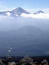 |  |