
|
|
Mountain/Rock |
|---|---|
|
|
19.25000°N / 98.43°W |
|
|
13618 ft / 4151 m |
|
|
Overview
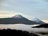
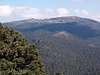
Tlaloc is sacred to the Aztecs as it was the site of an annual pilgrimage made by thousands to appease the rain God (Tlaloc) for which it is named (Tlaloc is also known in Mexican climbing circles as 'El Mirador'- the observatory). Tlaloc is about 20-25km NW of Iztaccihuatl and is part of the Sierra Occidental mountain range. Tlaloc is located in The Parque Nacional de Zoquiapan y Anexas a 19400 Ha park that is operated in conjunction with Izta-Popo Park.On the summit are the remains of an Aztec observatory, which today appear as nothing other than immense piles of rocks, which have painstakingly been gathered and arranged in rows... I stagger when I think of the effort people must have made to gather so many rocks in one place... it pales in comparsion to the pyramids of Teotihuacan... but it was still a serious undertaking. Tlaloc has a huge summit plateau over a kilometer long and a half-kilometer wide with plenty of nooks and crannies… false summits and a beautiful spine that one can play around on. There are bouldering and free climbing opportunities all along the spine the runs up the western edge of the summit plateau, in places the wall rises 20-25m or so... so there are plenty of places for those who want to boulder or enjoy a little free climbing.
From this striking rocky spine to the west one can see Nevado de Toluca and Ajusco on a clear day. The views of Malinche, Popo and Izta are awesome on clear mornings, and the sunset from the ridge is spectacular to behold. Also looking north from the summit the Mexican plins seem to strtech to the ends of the earth. It really gives one a sense of 'their' place in the world.
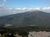
The area around Tlaloc's southern base is known as Manantiales which means 'spring' in Spanish. There is a spring which runs year round through the center of the valley. The forests are deep and cool... It is a vibrant place year round... green and full of life... which is a god send when the valley turns into a vast windblown dust bowl. At times like this Manantiales is a paradise.
Tlaloc is a relatively popular spot… though nothing in comparison to the volume Izta or Malinche would see. There are days when you could have the summit to yourself for hours at a time. The serenity on those days is palpable, a truly intense experience. The mountain is essentially a hike up from Rio Frio or San Pablo, but one should always pay attention to the weather and take the altitude seriously as at 13 615 feet it is a big peak.
 |  |  |  |  |
Getting There
Getting there is straightforward. You simply have to find your way to TAPO in Mexico City. From there it’s a 45-minute bus ride to Texcoco. Upon arriving in Texcoco another bus (third class) to San Pablo is required. Simply enquire at the terminal and they will be able t direct you where to go to catch the bus.Your stop is the very last stop in San Pablo where the bus turns around. From there follow a cobbled road that quickly turns into a dirt trail up into the hills. After an hour you should cross the aqueduct. This is the key to getting there. Follow this for 4-6 hours (a distance of about 11km or 7 miles) until the aqueduct disappears underground. At this point the summit of Tlaloc to the north is readily visible. As one makes there way north there is a marked trail (an obvious opening) that doubles up upon itself towards the summit.
Eventually it disappears and you will have to trail blaze to the summit. Which is easy as it is a hike up to the summit anyways. From Manantiales it should take no more than 2-3 hours depending on one’s physical condition.
There is a marked trail that leads to the summit but even locals who have summited dozens of times frequently get lost. The route that I have described is far and away the easiest path to the summit. As long as one is comfortable with a bit of trail blazing and is well acquainted with mountainous terrain.
Most of the guides in Mexico will only guide you up the major peaks so this is an adventure most would have to do on their own But it is well worth it.
One can also ascend the peak from Rio Frio a small town to the NE, I have been told that the route is straight forward, but I have little information becuase the two times I have been to Rio Frio it was cloudy and I couldn't see above 3000m.
 |  |  |  |  |
Red Tape
There are no camping permits required or user fees. The simplest rule to follow is to pack out what you pack in... it is a remarkable pristine area that the majority of visitors seem to take good care of and since the area is located in culturally significant area it is also important that one leaves things as they were when they arrived.When To Climb
The best season for climbing is November to March (which is the dry season in Mexico). Off season conditions can be questionable but it is still a fairly easy climb. The mountain can have very dynamic and variable weather so one should approach off season climbing prepared for all types of weather as like with any large mountain it is constantly changing.I have witnessed them blow in in less than five minutes and strike with some serious ferocity so please take the peak seriously, check ahead and come prepapred. |
Camping
Camping is allowed anywhere as there are no permits required. The best spot remains Manantiales which is the valley/saddle that it shares with its neighbour to the southwest Telapon. Anywhere near the aqueduct is a great spot as you have ready access to remarkably clean drinking water. There are no huts or incidental fees other than those incurred in getting there. |
ncst - Nov 17, 2009 10:11 am - Hasn't voted
Rio Frio routeI thought I'd leave a comment regarding the trail from Rio Frio. Like Tlogan wrote, nobody really seems to know how to get to the top, also from the Rio Frio side. Locals will somehow tell you, but there are many trails in that forest, allowed plenty doubtfull moments on which way to go. However, the main trail from Rio Frio starts at Av. Vicente Guerrero. It winds its way up Tlaloc, you could even go up this trail with a 4WD to about halfway. Then you'll have to take any of the smaller trails or trailblaze yourself to the top, which I reached after 4,5 hours.