
-
 5489 Hits
-
 83.1% Score
-
 16 Votes
|
|
Mountain/Rock |
|---|---|
|
|
28.08491°N / 17.3261°W |
|
|
Hiking, Scrambling |
|
|
Spring, Summer, Fall, Winter |
|
|
1686 ft / 514 m |
|
|
Overview
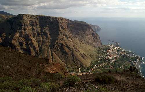 Las Pilas and Tequergenche as seen from La Merica Las Pilas and Tequergenche as seen from La Merica |
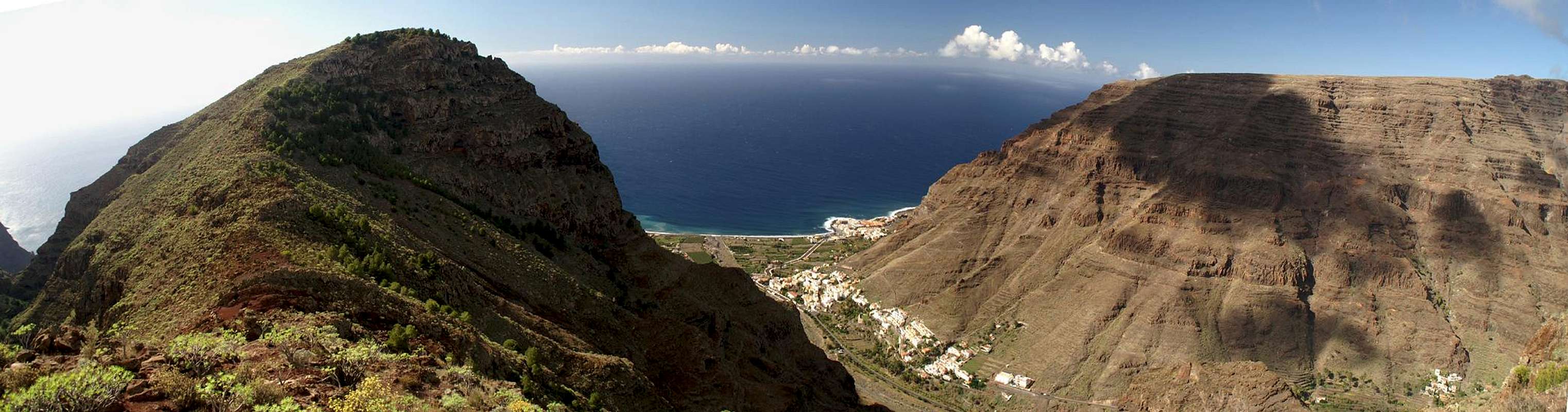
Valle Gran Rey is easily the most impressive of the valleys on La Gomera, the second smallest of the Canarian Islands. It is bounded by walls, up to 800m high, which only leave a narrow open stretch at the mouth of the valley. To the west you can find a tall and long stretched mesa, La Merica, while in the east several summit are lined up after each other: Tequergenche, Las Pilas, a high plateau not unlike La Merica, Montaña del Adivino and Lomo de Harinero. Especially the first two offer fine hiking opportunities and exceptional view along their faces to the east, south and west.
Tequergenche, the southernmost of the summits on this eastern ridge which bounds Valle Gran Rey, towers directly above the harbour of Vueltas. "Directly", in this case, means vertically as there is only a narrow strip which connects the harbour with Barranco de Araga on the other side of the mountain. On one side you have the sea, on the other a vertical face which reaches up for about 350m before retreating towards the Tequergenche summit.
Out of the multitude of hiking trails which crisscross this part of Valle Gran Rey several can serve as ascent routes to the mountain. All but one combine in Degollada de Cherillal where the difficult part of the climb is over. The remainder is a stroll across the high plateau of Las Pilas with its breathtaking views down into either of the valleys on its sides. From Tequergenche itself you are able to see into the bay of Araga vertically underneath and you also have the islands of El Hierro and La Palma aligned on the horizon.
The best way to experience Tequergenche is a round trip which starts at Vueltas, following a narrow road to Playa de Araga. From there a difficult (by hiking standards) scramble leads through the canyon-like Barranco de Araga to Degollada de Cherillal. Out of this canyon you can experience Tequergenche in all its imposing beauty as it is clearly visible across the canyon for most part of the climb. After summiting another descent route leads to Ermita de los Reyes to the west of the mountain and back to the trailhead at Las Vueltas.
|


Getting There
  |
In contrast to the large Canarian Islands, La Gomera and El Hierro don't have international airports. Reaching the islands therefore means switching to a local carrier at Tenerife (or any of the other Canarian islands) or use a ferry. Since weather is known to be unstable at the La Gomeran airport near Playa de Santiago, most travel offices will offer the ferry option.
Usually you will be able to book a flight to Tenerife South together with a bus transfer to the harbour at Los Christianos and the ferry to San Sebastian de La Gomera (bus transfer to your hotel on La Gomera is also included).If you want to travel on your own you can use ferries from either La Palma or Los Christianos and Santa Cruz on Tenerife.
There are several trailheads for the climb of Tequergenche. The shortest ascent route starts from El Guro, a village in Valle Gran Rey. It follows a path to Ermita de los Reyes and then up to Degollada de Cherillal. An Alternative but much more difficult route starts at the port of Vueltas through Barranco de Araga, a steep and narrow canyon. Quite naturally you can combine both routes. A third route starts at the hamlet of El Hornillo.
You reach the trailheads from San Sebastian de La Gomera via TF713, the Carretera del Centro, which connects San Sebastian with Valle Gran Rey. After passing the island's highpoint, Garajonay, you reach a three way intersection. Take the left road down to Valle Gran Rey and either park near the main road at El Guro or head down to the harbour of Vueltas, depending on the trailhead. For the El Hornillo trailhead leave the Valle Gran Rey road at one of the switchbacks following the sign "Los Descanderos". There is a parking lot between La Vizcaina and Higuera del Lago.
|


Red Tape
 Spider web barring the way in Barranco de Araga
Both Tequergenche and the high plateau of Las Pilas belong to the Parque Natural de Valle Gran Rey. Though extensive farming is allowed in the park, overnight camping is not. An exception is Playa de las Arenas near the Vueltas trailhead. Here quite often a group of people camp overnight. Technically it's not allowed, though. Also, parts of the Araga Canyon are privately owned and warning signs warn that trespassing is not allowed. Apart from this the usual rules for natural parks apply.
Accommodation
 Dizzying view towards Vueltas
Of course you can find a lot of hotels, fincas and casas on the island which you can book from any travel office. Valle Gran Rey is the main tourist location on the island. There you can find all kinds of accommodation with the exception of campgrounds. Wild camping is not allowed and is only tolerated at Playa de las Arenas east of the Araga Canyon.
Weather Conditions
There are few sites on the web, which deal with the weather for La Gomera. The island just is not very popular with the tourist crowd. The ones you can find are for San Sebastian, which is located on the other side of the island. Generally Valle Gran Rey and its surroundings are pretty weatherproof with sunny days when the rest of the island lies under a thick cloud cover. Tequergenche and the Las Pilas plateau are exposed to winds of all directions, which often can be very fierce on the Canarias. Windproof clothes are mandatory even if the Valle Gran Rey beaches are scorchingly hot.The following table gives a rough general overview over the weather on La Gomera, at sea level.
| Month | Jan | Feb | Mar | Apr | May | Jun | Jul | Aug | Sep | Oct | Nov | Dec |
| Avg. day temp.[°C / °F] | 20 / 68 | 20 / 68 | 21 / 70 | 22 / 72 | 23 / 73 | 25 / 77 | 27 / 81 | 29 / 84 | 27 / 81 | 25 / 77 | 23 / 73 | 21 / 70 |
| Avg. night temp.[°C / °F] | 15 / 59 | 15 / 59 | 15 / 59 | 16 / 61 | 16 / 61 | 18 / 64 | 20 / 68 | 22 / 72 | 21 / 70 | 20 / 68 | 17 / 63 | 17 / 63 |
| Water temp.[°C / °F] | 19 / 66 | 19 / 66 | 19 / 66 | 19 / 66 | 20 / 68 | 21 / 70 | 22 / 72 | 23 / 73 | 23 / 73 | 22 / 72 | 22 / 72 | 21 / 70 |
| Rainy days | 11 | 8 | 6 | 5 | 2 | 1 | 0 | 1 | 2 | 6 | 8 | 8 |
Maps & Books
Out of the multitude of maps and books I have been using the following. However, so far I have not found a good hiking map of the island. The one posted here is ok but shows only a fraction of the marked hiking trails. The book is very good though they stretched it a bit by describing 50 routes on the island. All three routes to Tequergenche are detailed in separate tours in the boo though you can easily combine two of them in a neat loop.- Maps
- La Gomera
Kompass Map WK231
Kompass Verlag
ISBN: 978-3-85491-015-2
Books
- La Gomera
Klaus Wolfsperger / Annette Miehle-Wolfsperger
Rother Verlag
ISBN 3-7633-4007-6 (German)
ISBN 3-7633-4823-9 (English)