
-
 44374 Hits
-
 86.85% Score
-
 23 Votes
|
|
Area/Range |
|---|---|
|
|
28.10976°N / 17.24838°W |
|
|
Hiking, Scrambling, Canyoneering |
|
|
Spring, Summer, Fall, Winter |
|
|
4879 ft / 1487 m |
|
|
1 - The Wildest One
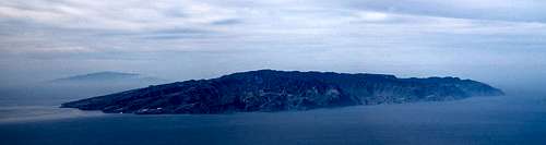 La Gomera and El Hierro (behind) as seen from Roques del Cedro on Tenerife. |
La Gomera, the next to smallest island of the Canaries, has been called the wildest of them all. Though its highpoint doesn’t quite reach 1500m, though it is an anticlimax as highpoints go, though there is only one real mountaineering objective, La Fortaleza de Chipude, the island surely deserves the description. It is a veritable hikers’ paradise offering hikes and scrambles of all lengths aspects and difficulties. And you can barely go wrong as the important routes have been marked extensively.
La Gomera’s wild aspect is caused by its geologic history, the first half of which was dominated by volcanism. La Gomera was created 12 million years ago by cleft volcanism where the magma is emitted along long fissures in the ground. Along with the magma huge amounts of cinder and ash were also emitted forming the near circular shape of the island. Gradually, however, volcanism stopped and for the last 2 million years there has been no eruption at all on the island. This is when erosion took over in forming the landscape and thanks to large amounts of rainfall over the millennia it is estimated that today already half of the bulk of the island has been washed away to the sea.
Erosion formed large canyons, the barrancos of La Gomera, which run from the centre of the island to its outskirts. In the north, where volcanism stopped earlier the barrancos have become rather wide while the ridges in between, the lomos, have become knife-edge like in character. In the south these ridges are rather broad and mesa like with very narrow barrancos, bounded by near vertical walls. Today there are about 50 barrancos heading out from the island’s centre to the sea.
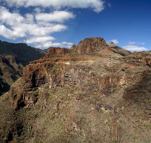
Every here and there – rather often in fact – you come across the remains of the magma emitting fissures, in which magma has cooled down to form large solid blocks off basalt. These structures tend to stand alone above the washed out barrancos, offering very impressive views and very wild aspects. The Techeleche mountains in the west of La Gomera are a good example of these kind of volcanic structures.
Last – but in no way least – La Gomera is home to half a dozen rock towers, former volcanic plugs, where lava was funnelled to the top of the volcanoes. Most of them are located at the south-western boundary of the Parque Nacional de Garajonay, La Gomera’s largest national park (see below) and rise out of the cloud forest like giant cones. Near Hemigua and Vallehermoso in the north as well as Imada and Benchijigua in the south there are more of these towers, all looking very wild and inaccessible.
As said above, La Gomera is perfect for hikers. In the 16th and 17th centuries Gomerans created Caminos and Mulaterias between the villages in the mountains and at sea levels. In the last years these Caminos have been revised and marked. Often they take the direct route between the two endpoints regardless of the terrain so that you find yourself climbing up an improbable vertical wall on an exposed ledge-like and switch backing trail. There is a veritable web of these paths, connecting to any interesting point. Moreover there are two trekking trails, GR131 and GR132. The former climbs across the central mountain range, connecting San Sebastian in the east with Vallehermoso in the west while the latter circles the island high above the coast. GR131 takes 2 to 3 days to complete, GR 132 5 to 8 days.
2 - La Gomera on SP
  |
La Gomera cannot easily be divided in different mountain ranges. There is the central highland around Garajonay, the island’s highpoint but not much more. The remaining mountains of the island are located on the ridges between the various barrancos. Therefore generally the island is divided by the directions of the compass. I added two additional regions, the central highland in the Parque Nacional de Garajonay and the greater region of Valle Gran Rey in the south-west of the island. All are described in the following sections and mountain pages will be added to the appropriate sections as they appear on SP.
3 - Parque Nacional de Garajonay
 Garajonay as seen from La Fortaleza
The centre of the island of La Gomera is dominated by the north-western trade winds. The humid air, being forced to rise above the mountainous centre of the island condenses and often forms dense clouds which cover the mountain tops, especially in the north. This cloud cover creates the conditions for one of the rarest types of forests on earth, the Canarian laurisilva or laurel forest. All of the Canarian islands that exceed 1000m in elevation have their laurisilva patches but none as large as La Gomera. More than 10% of the island’s area (4000ha from 369square km) are covered by this dense cloud forest, offering a habitat for a large variety of endemic plants and animals (mainly birds).
The whole area has been set aside as a national park, the Parque Nacional de Garajonay, which itself has been declared World Heritage Site by UNESCO. It is a strange kind of forest. The trees rarely exceed 20m in height, nevertheless inside it is as dark as a forest can be. The trees are covered with lichen and moss, often sporting beards of several metres length. Thanks to the wet conditions the turf is very slippery and descending one of the hill-like summits can become nightmarish. You should not leave the roads, paths and trails since it is easy to get lost inside the laurisilva. The park management has created a network of marked trails which connect the major points of interest within the forest.
Though the park contains all summits above 1300m on the island it nevertheless is of no mountaineering importance. The summits are all hill-like and tree covered and solely Garajonay, La Gomera’s highpoint is of some interest. Some of the other peaks can also be climbed but apart from Alto de Igualero, the antenna decorated neighbour of Garajonay none are.
 Roque de Agando
Right outside the park – in its south-east you can find another small park, the Monumento Natural de Los Roques. Here three impressive towers, former volcanic plugs remain standing, Roque de Agando, Roque de la Zarcita and Roque de Ojila. All three used to be climbing destinations in the past (especially Roque de Agando with some 200m long, UIAA IV and V graded routes) but with the advent of the UNESCO World Heritage Site they have been declared off limits. Within the laurisilva forest the Roques are the main tourist destination. The road from San Sebastian to Valle Gran Rey passes in their midst and several miradores have been established to offer good views for the crowds.
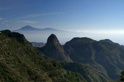
4 - The East
 Tenerife above the eastern part of La Gomera
The eastern part of the island can be defined as the area east of the Hermigua Valley in the north and the wild Barranco Juan de Vera in the south. It is one of the most inhabited areas on the island since the capital, San Sebastian de La Gomera is at its centre. About xxxx of La Gomera’s xxxxx inhabitants live in the greater San Sebastian area and consequently you have to account for a lot of “civilization out east.
Nevertheless the region contains one of the most inaccessible mountain ranges on La Gomera, the Cumbre de Carbonara, which bounds the Hermigua Valley to the east. It’s highest mountain, Enchereda, has been closed to hiking for environmental reasons and thus only on hiking trail crosses the range at Degollada de la Cumbre right above the Hermigua – San Sebastian road. The Cumbre Carbonara is a long wooded ridge, running from the centre of the island to the north and sporting impressive faces on its western side.
Apart from Cumbre Carbonara you can find several other long ridges, which separate frofound Barrancos. The best known is the one running from Degollada de la Cumbre to San Sebastian, where you can find several hiking destinations like Altos de Uteca, Montaña Ismael or Jaragan, all of which are nicely visible from the island capital.
The southern boundary, Barranco Juan de Vera, is one of the wildest of the whole island. Bounded by two rock-studded ridges it also contains many lava walls, proofs of the fissures with formerly emitted the lava, which created the island. The rock structures along the ridges are all made up from beautiful solid basalt pillars and if it weren’t for the long access routes would make for perfect climbing venues. The private holiday resort El Cabrito at its mouth, however, amounts to an anticlimax of that beautiful canyon.
5 - The South
 Pico Gomero and Roque del Sombrero
The south of La Gomera, between Barranco Juan de Vera in the east and Barranco de la Rajita in the west is of the least mountaineering interest of all the regions on the island. Like all other regions it contains its share of Barrancos but thanks to the towns of Playa de Santiago (and its airport) and Alajero, the region’s capital, it is home to a lot of purely touristic attractions like a Golf Course or the only old Drago tree of La Gomera.
The exception from this rule is Barranco de Benjichigua, which leads up to the island’s centre with Roque de Agando at its end. There is a nice loop hiking trail from The Carreta del Centro to Imada, Benchijigua, Roque Agando and back, one of the most exceptional routes on the island. After the closure of Los Roques for climbing, Roque de Imada, a tower of secondary importance is one of the last remaining climbing objects on the island.
Thanks to the lack of rain in the south of La Gomera the region is the main area of retreat in case of foggy weather in the north and centre. It offers long hiking routes, which, however, lack the beauty of some of the routes in the other regions. The area is simply too arid to be attractive.
6 - Valle Gran Rey
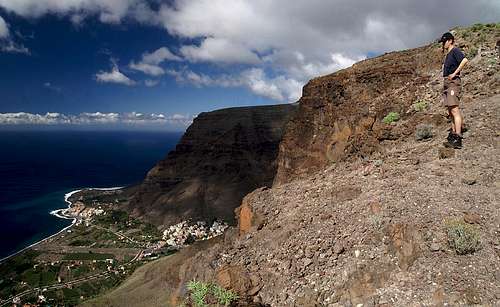 High above the mouth of Valle Gran Rey
Valle Gran Rey, the Valley of the Great King, is the main touristic spot on La Gomera. Mainly German tourists spend their vacation here, choosing between the beaches and the impressive hikes and scrambles along the bounding Mesas of the valley. The region encompasses all the area between Barranco de la Rajita in the east and the Taguluche Valley in the west and is home to the sole mountaineering destinantion on the island, La Fortaleza de Chipude. La Fortaleza is a circular table-top mountain formed out of solid red basalt towering high above the Baranco de Earque with its red east face. The normal ascent, formerly a UIAA I / II affair has been degraded into an exposed scramble thanks to steps which have been hewn out of the north-eastern chimney route.
Apart from La Fortaleza there are two very interesting Mesas – the ones which form the boundaries of Valle Gran Rey. To the west there is a high ridge, starting at Arure in the north and ending directly above the Valle Gran Rey beaches. La Merica, as it is called was used as cattle grazing ground in former years but now is left to the many hikers who want to follow the ridge and descend to the coast. La Merica is 855m high and climbing the switchbacks of the camino which leads to its top from Valle Gran Rey is quit challenging especially on sunny days. It’s advisable to start very early in the morning.
To the east of Valle Gran Rey there is another set of mesa like summits, Lomo de Harinero, Montana de Adivino, Lomo de Las Pilas and Tequergenche, the latter standing 600m high above the port of Vueltas. Like La Merica on the other side of the Valle the summits in the east are very panoramic but made up from very brittle rock. Unlike La Merica there are barrancos which separate the summits and personal experience shows that crossing one of these can turn out to be a very dangerous affair.
To the east of Tequergenche there is Barranco de Araga, a short but profound canyon, which is the most difficult route to the Tequergenche summit. After passing the buildings at the mouth of the barranco the route turns into a veritable dance across ledges and through chimneys before the canyon turns into a palm studded valley in its upper part. All in all it is probably one of the most difficult hiking routes on the island.
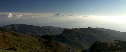
7 - The North-West
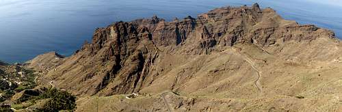 The Techeleche Range as seen from the ascent to Lomo de Carrreton
To the north La Merica suddenly drops off into Barranco de Taguluche, one of the most beautiful settings on La Gomera. This profound barranco is bounded by impressive walls on three sides and open only to the sea through a narrow mouth. In addition to the La Merica north face in the south of the barranco, Lomo de Carreton, a broad backed ridge bounds the valley to the east with beautiful reddish basalt walls. But the show of the valley is the small Techeleche Range, probably the wildest range on the island. It is one of the youngest parts of La Gomera but also lots of its substance has eroded into the sea. Thus you find a wonderful setting of towers which rise out of the sea for up to 600m. In between a lot of lava walls bear witness to the history of the area – long fissures which emitted the brittle substance of the range.
To its north – across Barranco del Mono - the north-western part of La Gomera turns less wild. However, the coast is inaccessible for most of the region, only at Ajolera and Arguamul two roads get close to the sea. The region is separated by a long, broad and tree-covered ridge by the Valley of Vallehermoso, a popular hiking destination thanks to the easy roads and perfect views in the area. On a good day Tenerife and La Palma can bee seen from the ridge, which reaches its highpoints at some 900m at Montaña de la Puntilla and Montaña de la Caldera.
8 - The North
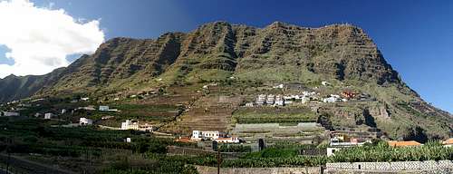 Lomo Gordo in the north of La Gomera
The north of La Gomera, like the south, is of little mountaineering importance. It stretches between the valleys of Vallehermoso to the west and Hermigua to the east. The coast itself is inaccessible for most part and the Carretera del Norte, the winding main road in the north of the island takes up much space in the countryside behind. Near Vallehermoso, several interesting Rock formations can be found, the most impressive of which is Roque El Cano, which towers high above the little town in the north.
Another interesting destination is Lomo Gordo, a broad backed Mesa, which separates the Hermigua Valley from the Agulo. Though the top of the lomo can be reached by car from the centre of the island it has two interesting ascent routes and probably the best view of Tenerife you can get on La Gomera. From the Hermigua side in the east a camino climbs a spur of Lomo Gordo, sometimes breathtakingly exposed but never really difficult. From Agulo another camino winds its way through the Red Wall, a vertical basalt wall right above the little town.
Last but not least one should mention Los Gemenos, the twin rocks at El Estanquillo, two former volcanic plugs which tower above the Hermigua Valley. Unlike the other rocks on the island Los Gemenos have not been placed inside a natural monument and thus are easily accessible. However, the hamlet El Estanquillo surrounds the rocks with houses right up to their bases.
9 - Traffic and Accommodation
The small Canarian islands, La Gomera and El Hiero, can only be reached by a relayed flight schedule or by using one of the ferries from Tenerife or La Palma. Both islands have regional airports which are only served by the local carrier. Moreover weather often is unstable at the airports that flights can be delayed of are cancelled altogether. As for ferries – still the regular mode of travelling – you can choose among different carriers and different starting harbours. Generally travel offices will book the whole itinerary from your home airport to the hotel or apartment complex. It will include the flight to Tenerife south, bus transfer to the harbour (Los Christianos), ferry transfer to La Gomera or El Hierro, and the bus transfer to the hotel.
As for accommodation, you can rent hotel rooms and apartments from any travel office in Europe (overseas might be a bit more difficult). Many of the large companies have their own web sites so that you might look them up there as well. For fincas you can try to contact locals from a web based search – many expatriates offer their own houses for use by tourists. It takes a bit of research on the web however. Make sure you book a flight before you book the apartment, especially over the Christmas or Easter holidays. Flights are always sold out during these times.
Local transport is available by bus. There are bus lines between the major towns on the islands. Since there are only a handful of regional roads this amounts to a thorough network and you’ll be able to reach anywhere on the island, especially if you are prepared to hike a bit. Make sure that you know the schedule, however. Some lines are served only once or twice a day.
Therefore renting a car might be advisable after all. You can rent small cars in any of the tourist resorts as well as from the harbours or airports. Prices are somewhat lower than in continental Europe though still quite high. Also without a hotel address the car rental companies tend to give you run-down cars.
10 - Red Tape
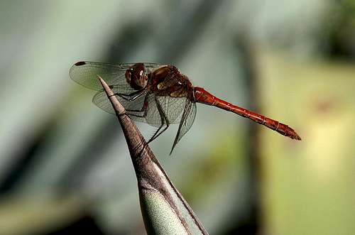 Dragonfly near Benchijigua
La Gomera is a veritable patchwork of national, regional, local and natural parks. Apart from the Laurisilva in the Parque Nacional de Garajonay the park rules are not overly restrictive. Local farmers tend to let their sheep and goats graze in the areas so that there is always a passage through the parks. Of course, no plants may be collected and the few Gomeran animals should not be disturbed.
The Garajonay Park additionally has the restriction that noone is allowed to camp in its limit and that open fire is only allowed in the designated areas. Also, since it has been declared world heritage site, climbing is not allowed on the Roques at its south-eastern boundary.
11 - Weather Conditions
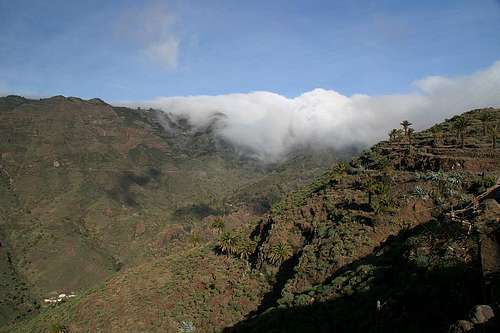 Trade wind clouds
There are few sites on the web, which deal with the weather for La Gomera. The island just is not very popular with the tourist crowd. The ones you can find are for San Sebastian. The following table gives a rough general overview over the weather on La Gomera, at sea level.
| Month | Jan | Feb | Mar | Apr | May | Jun | Jul | Aug | Sep | Oct | Nov | Dec |
| Avg. day temp.[°C / °F] | 20 / 68 | 20 / 68 | 21 / 70 | 22 / 72 | 23 / 73 | 25 / 77 | 27 / 81 | 29 / 84 | 27 / 81 | 25 / 77 | 23 / 73 | 21 / 70 |
| Avg. night temp.[°C / °F] | 15 / 59 | 15 / 59 | 15 / 59 | 16 / 61 | 16 / 61 | 18 / 64 | 20 / 68 | 22 / 72 | 21 / 70 | 20 / 68 | 17 / 63 | 17 / 63 |
| Water temp.[°C / °F] | 19 / 66 | 19 / 66 | 19 / 66 | 19 / 66 | 20 / 68 | 21 / 70 | 22 / 72 | 23 / 73 | 23 / 73 | 22 / 72 | 22 / 72 | 21 / 70 |
| Rainy days | 11 | 8 | 6 | 5 | 2 | 1 | 0 | 1 | 2 | 6 | 8 | 8 |
The Canarian Islands (as well as Madeira) are located in the trade wind zone. You almost always encounter northeastern winds which carry a lot of humid air. Being forced to climb to higher altitudes this moisture condenses into clouds. This in return means that most of the time the northeastern part of the islands is covered in clouds from altitudes of 1000m through 1500m.
The mountainous region in the centre of the island is of the same alltitude and thus stops the clouds. While the northern parts of the islands can be foggy and rainy the southern parts most often are sunny and hot. On La Gomera the centre of the island collects almost all moisture in a big cloud forest, the laurisilva. It is the largest consecutive cloud forest on any of the Canarian islands and has been declared world heritage site.
12 - Maps & Books
12.1 – Maps
Obviously there are no decent hiking maps of the island. It appears that in some regions the topographical data differs from the reality on the ground so that three different map sets can show three different sets data while the reality is different again. For hiking purposes the following map is adaequate though not perfect.
- La Gomera
Kompass Map WK231
Kompass Verlag
ISBN: 978-3-85491-015-2
12.2 - Digital Maps
Kompass is the only company known to me which offers GPS digital Maps. In addition for those of you with Garmin GPS receivers there is a map source map set of all Canarian islands out there with the exception of Lanzarote. Currently you can download it for free.
- La Gomera
Kompass GPS4231
Kompass Verlag
ISBN 3-85491-425-3 - Islas Canarias
Map Source custom map
By Manfred Pepper
downloadable zip-file
12.3 – Books
An excellent hiking guide available in both German and English is:
- La Gomera
Klaus Wolfsperger / Annette Miehle-Wolfsperger
Rother Verlag
ISBN 3-7633-4007-6 (German)
ISBN 3-7633-4823-9 (English)