
|
|
Area/Range |
|---|---|
|
|
52.70559°N / 3.05151°W |
|
|
Hiking, Mixed |
|
|
Spring, Summer, Fall, Winter |
|
|
1322 ft / 403 m |
|
|
Section-1 Area Overview:-
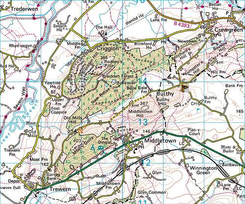
Within the vast area of hills that span from the towns of Welshpool through to Hay on Wye in Wales is the range of hills known as, The Breidden Hills. This range stands only just in the vast Welsh county of Powys and just over the border from the large land-bound English county of Shropshire. Land bound meaning the county of Shropshire has no coastline. The latitude and longitude given are those of the highest summit within the Breidden Hills range which is that of Moel y Golfa at 403 metres. Although Long Mountain is higher than Moel y Golfa, Long Mountain being 408 metres it is not really part of the Breidden Hills range. The reason it is included in this page is due to it being so close to The Breidden Hills and is of a similar height and status.
The Breidden Hills are of considerable interest. They are a conspicuous group of upland that were created through extreme volcanic actions and the highest summit of its three main peaks is that of Moel y Golfa at 403 metres. The other two main summits within this range are that of Breidden Hill at a shorter height of 365 metres and the summit of Middletown Hill at 367 metres that sits in the middle. All three of these hills are relics from violent active volcanic times but the truth behind them is that the volcanoes never actually came to the surface! Instead, the volcanic actions that took place here forced newer, younger rocks out of the ground and up into a dome formation, the three summits together forming an impressive cluster of hills grouped in a saddleback.
The hills here can be seen from many miles around and they stand guard over the entrance into this part of Wales when travelling on the main A458 road that connects Shropshire’s county town of Shrewsbury through to the market town of Welshpool or Y Trallwng in Wales. These hills also look a lot higher than they actually are, especially when seen from the main A483 road travelling from the Shropshire town of Oswestry in the north west of the county and heading in a south direction through into Wales again at Welshpool.
The reason these hills look so much higher when in view from this road is because you are looking out across the vast flat plains of the great River Severn and as there are no other large hills within the area it is very difficult to scale them against anything. This issue of difficulty with there scale also counts when viewing from the north east and the east primarily in the county of Shropshire. Again from these angles you are looking across the plains of the River Severn which meanders round the west and north side of these hills from Welshpool through and on down stream to the great town of Shrewsbury.
One thing with them is that for relatively small hills and being below the 500 metres height there conspicuous shape makes them so easy to pick out from many other surrounding summits within both England and Wales. This is also true the other way round as from all three of these summits many other English and Welsh summits are also visible.
The hills here have played many roles through there times especially in the times of battle and defense of our country. There are the remains of hill forts dating from the Iron Age period when through the years from the 2nd World War and the Cold War to the year of 2003 there was a major antenna array consisting of impressive masts and towers. See the section about Breidden Hill for more information about this impressive Radio Station which also has a link to a designated page.
| Summit Top - Name | Height m | Height ft | Summit Feature | Grid Ref and Streetmap Links |
| Moel y Golfa | 403 | 1322 | Monument | SJ 29050 12515 (Streetmap Link) |
| Middletown Hill | 367 | 1204 | Iron Age Hill Fort | SJ 30505 13330 (Streetmap Link) |
| Breidden Hill or (Rodneys Pillar) | 365 | 1198 | OS-Trig Point and Monument | SJ 29505 14440 (Streetmap Link) |
| Long Mountain (Beacon Ring) | 408 | 1339 | OS-Trig Point and Hill Fort | SJ 26465 05830 (Streetmap Link) |
Section-2 Moel y Golfa:-
As explained in Section-1 Long Mountain is higher than this summit but in all truth it falls out of the actual Breidden Hills range so will be mentioned later on in Section-5.
 |
 |
 |
Moel y Golfa meaning "Bald or Bare Hill" is the highest within The Breidden's at 403 metres commanding fine views from its summit especially out to the west. The hill overlooks the two small villages of Middletown to its east and Trewern to its south west. It is a steep sided and long elongated ridge of volcanic activity that forms a whale back in a north east to south west direction and its north east neighbour that of Middletown Hill which is also part of the same volcanic ridge gives them a more conical look when seen from the east or west as in the center picture above where it is viewed from near Welshpool. An interesting feature of Moel y Golfa are the fantastic wind swept trees atop its summit taking the shapes of large bonsai trees from Japan. These trees where stunted into shape by the strong prevailing south-westerlies that the hill is prone to in the worst of British weather conditions.
The summit of Moel y Golfa being the highest in the range also has the status of a UK Marilyn.
What is a UK Marilyn...?
Well its status as a UK Marilyn means that it is a mountain or hill in the British Isles (including Ireland) with a relative height of at least 150 metres (492 ft). This is regardless of its absolute height or any other merit that the summit may have. The name Marilyn was coined as an ironic contrast to the designation Munro, a term used for a Scottish mountain with a height of / or more than 3,000 feet, which is homophonous with (Marilyn) Monroe.
Moel y Golfa at its top has three humps where the middle one is dominated by an impressive monument but the monument here is no where near as grand and tall as the one atop that of neighbouring Breidden Hill or (Rodneys Pillar). The monument here on Moel y Golfa is surrounded by railings sadly in a state of disrepair and has two very interesting dedications on it. These two dedications are in memory of two Romany Chells (Gypsy Kings), one being the son of the other. The son had the monument raised in memory of his father, who is now himself remembered in the remarkable words carved on the newer plaque.
Another interesting story associated with this monument is that when the final stones were to be taken up and raised into position, several labourers who were drinking at a pub in Wellington, a small town near to the large area of Telford in Shropshire had been "kidnapped", taken to Moel y Golfa, and then made to do the work before being let go. Also a local farmer who was "not" kidnapped, was later employed to do the final work.
The two plaques upon this monument read as follows along with some more pictures of this fine summit and its views.
| This monument was erected in remeberence to Ernest Burton, Romany Chell Who was cremated at Cholton Cum Hardy 1960 His wife Dora was interred 1956 His wish was for his ashes to be scattered on this mountain top The memorial was erected by his sons and friends |
| This monument was erected in memory of his father by Uriah Burton, Romany Chell Better known as Hughie or Big Just Died 5th November 1986 His wish was for his ashes to be spread on this mountain Uriah was a fighter for the weak the good and the poor teacher to the ignorant and a true legend in his own time. He was known and respected by all gypsies and creeds. He was never beaten in fisty cuffs from the age of five to sixty. A man who led his people into the twentieth century. He was a good Husband, Father and Grandad and was truly loved by all his family. |
 |
 |
 |
Section-3 Middletown Hill:-
As it says at 367 metres is the middle one in height of the three main Breidden Hills.
"This is not why the hill gets its name."
 |
 |
 |
The name here is derived from the small village the hill overlooks and that is the village of Middletown situated on the busy A458 Shrewsbury to Welshpool road. The hill is also known to some as Cefn y Castell. In comparison to Breidden Hill and Moel y Golfa the steep banks of this hill are a lot more open and not as overgrown with trees. It is a shame Middletown Hill has no status within the UK summit listings as the views from here especially when looking to the east and the south are so much better than the views available from much higher, neighbouring summit of Moel y Golfa.
Middletown Hill consists of a large open grassy dome and creates part of the ridge from the volcanic action which Moel y Golfa is also a part of. The summit is crowned by the remains and rampart earthworks of a very impressive Iron Age hill fort. This hill fort is said to have been the site of the last stand of "Caractacus" who was a historical British chieftain of the Catuvellauni tribe, he led the British resistance to the Roman conquest.
Middletown Hill commands fine views out to those of The South Shropshire AONB area and as far over to the east as the Pennines and The Wrekin. The ridge that runs off from Middletown Hill also has two much smaller hills which were both created by the same volcanic uplift action and these are the hills of Kempster’s Hill and Bausley Hill which run off in a north east direction.
Section-4 Breidden Hill:-
This is the summit that gives the range here there name but it is not the highest of them. The hill is 365 metres, only 2 metres shorter in height than Middletown Hill but one thing with Breidden Hill is that it has to be the most "remarkable and interesting" of the three.
 |
 |
 |
Many books and web sites say this mountain seems to rise almost vertically from the great plains of the River Severn especially when seen from the north, north west or north east across this vast flat area of land. Although the mountain here is actually Breidden Hill, virtually everyone who knows of it refers to it by the name of Rodney’s Pillar. This is due to the large stone monument that stands on its summit. The impressive steep natural rocks and cliffs that drop from the summits north to north west faces are those of Craig y Bryn and in places are almost shear. A lot of these cliff faces have now been fenced off from the public primarily for safety reasons due to recent extreme quarrying activity that has seriously scarred the north west face.
Rodney's Pillar (The Monument)
In the 18th century a gentleman named Admiral George Brydges Rodney achieved some spectacular naval victories against both the French and the Spanish fleets. This tall grey pillar was erected by the local gentry in recognition of the fact that the ships he used were built of oak wood supplied from what was then the county of Montgomeryshire. The hill has gone through a lot of changes through the years and one of these has been the west and the north west side of the hill which has been heavily scarred by quarrying to yield granite and basalt mainly supplied for materials such as road stone and railway balast. The quarry here is owned by the large aggregates company of Hanson. Being granite and basalt of course shows that these hills were once of a volcanic nature! One thing is if you visit the summit of this hill on a working week day the sound of the quarry machinery and of course the explosions can really ruin the peace and quiet so you are to be honest a lot better off visiting the summit on a Saturday or Sunday when no quarry workings are taking place.
More information about Rodney’s Pillar via this link: "Rodney's Pillar"
Although dwarfed by the monument of Rodney's Pillar the summit has an Ordnance Survey TRig Point. This is the only hill within the area/range to have one. I guess this was due to the vantage point this hill has when looking out across the vast flats of the River Severn. The trig point has a reference number which is number (S4796) for those who access the hills bagging UK trig points. The summit also has the remains of a hill fort consisting of a few rampart earthworks but these are not obvious and no where near as impressive as those of Middletown Hill.
 |
 |
 |
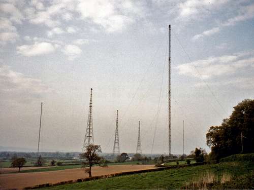
Criggion Radio Station
Another role this hill has been associated with was in the defence of our country. This is really interesting in that with the hill having an almost shear drop of 900 feet on its north face it was used to support a gigantic antenna array known as the Criggion Radio Station. This radio station consisted of three stayed masts at an impressive height of 720 feet and three self supporting towers at a height of 680 feet. The structures where set out in a way that the large cable antenna they supported was also supported by a winch and bond set up near the very summit of Breidden Hill. This winch suspended it out from the cliffs across to the central tower at the transmitter hall. The site and its antenna array in total covered over 3 acres of land at the base of the hill and the weight of the cables supported to make the array was 42 tons.
The radio station here has sadly gone as technology superseded it and the site was therefore not required anymore. Its main purpose was a back up site to the much bigger antenna array that was at Rugby in Warwickshire and that site too has now gone. Criggion was decommissioned in the year 2003 and all 6 structures where removed. The only part of the site that is now left include the remains of the transmitter hall along with its outbuildings and the winch house. The transmitter hall and outbuildings are all at the base of the hill when the winch house is high up on the cliff face above the quarry near the summit of Breidden Hill.
There is so much more that can be said about this radio station and the history it has played in our country so if you wish to know a lot more information about it follow the link below.
 |
Criggion Radio Station more information via this link: "The secret masts of Criggion"
These three hills are not too high and certainly not the most difficult to access and as each summit has its own separate advantage on the direction it looks and the views they can offer I advise you to visit all three of them whilst you are in the area. I also heavily advise a visit to the neighbouring summit of Long Mountain at its highest point Beacon Ring which is in the next section.
Section-5 Long Mountain:-
To the south of the Breidden Hills and overlooking the small market town of Welshpool to its west is the long sweeping hill known as Long Mountain. This to be honest has no true connection with the Breidden Hills as it is divided by the A458 road and the railway that connect the towns of Shrewsbury and Welshpool. The hill still falls into the area of Welshpool to Hay on Wye and is of a similar height at its summit called Beacon Ring which is 408 metres. Like Moel y Golfa Long Mountain at Beacon Ring also has the status of a UK Marilyn and also has an Ordnance Survey trig-point.
 |
 |
 |
The reason I have included Long Mountain at Beacon Ring is that it is certainly worth visiting if you are in the area due to its status. The trig point here reference number (S4718) is now hidden deep within some heavily overgrown woodland that covers the large area of rampart earthworks that were once part of the mighty Beacon Ring hill fort. These are similar to the Iron Age earthworks that crown the summit of Middletown Hill back in the Breidden Hills range.
The summit of Long Mountain is easily accessible by car and the long roman road that runs along the top of its ridge in a south west direction reaches a high point of 382 metres at the point known as Short Cross. This is near to the two radio towers that also crown the hills summit. These two radio towers are next to a track leading to Beacon Ring. You can park your car at Short Cross near to these towers and walk along the track through to the Beacon Ring hill fort and trig point. The two towers here are for telecoms and broadcast. The tallest of the two towers is a major high power TV Relay owned by the large company of Arqiva which also has local radio for the surrounding population when the smaller one situated within the grounds of a covered reservoir is a multi site share structure for other users and is owned by the large energy company of Eon.
If you are walking the long distance route of the Offa's Dyke footpath you will also cross the summit of Long Mountain at Beacon Ring. The open land that surrounds the summit of Long Mountain consists primarily of large fields for the grazing of sheep.
Section-6 The Summit Views:-
These are the other summits and hills which are in view giving details of the advantage each summit has to offer:-
Breidden Hill or Rodney's Pillar:
From the west to the north the summits and hills in Snowdonia National Park are those of Cadair Idris, The Arans and part of The Berwyns. Th main summit of Cadair Berwyn is not in Snowdonia but still visible when in the northern parts of Wales are The Clwydian Range. In north Cheshire the Peckforton Hills and Delamere Forest can be seen.
From the north to the east hills as far as Winter Hill (Manchester), most of the Pennines can be seen. In neighbouring Shropshire, The Cliffe (Nescliffe), Pim Hill, Grinshill, Haughmond Hill and The Wrekin are all in clear view.
Middletown Hill:
From the east to the south most of the hills within The South Shropshire Hills AONB are visible these include The Wrekin, The Lawley, Brown Clee Hill, Caer Caradoc, Long Mynd and Stiperstones.
From the south to the south west the Welsh hills of Corndon Hill, Long Mountain, Radnor Forest (Black Mixen Radio Tower) and Plunlumon Fawr are in clear view.
Moel y Golfa:
The views south and to the west like Middletown Hill the hills of Long Mountain, Radnor Forest (Black Mixen Radio Tower), Plunlimon Fawr can be seen when the summit of Cadair Idris is visible in the far west.
The views west and to the north like Breidden Hill include The Arans, The Berwyns and The Clwydian Range in Wales and the Peckforton Hills in Cheshire.
 |
Section-7 Getting There:-
Access to the Breidden Hills is not complicated as the three main towns to head for are those of Oswestry and Shrewsbury in England or Welshpool in Wales.
From Shrewsbury:
Shrewsbury is the main town to aim for if you are heading anywhere from the eastern region including the Midlands. Shrewsbury is easily accessible from the main cities of Manchester, Liverpool and Birmingham with connections by road from the main M6 motorway.
Once you have reached Shrewsbury you take the A458 primary route road off the A5 bypass signposted for Welshpool and you will pass the Breidden Hills when at the villages of Middletown and Trewern.
From Oswestry:
Oswestry is the main town to aim for if you are heading anywhere from the northern area of Cheshire, Liverpool or North Wales. The main road from Chester, Wrexham through Oswestry then on to Welshpool is that of the A483 primary road. Chester can also be accessed from Liverpool and Manchester via the M56 and M53 motorways then bypass Chester on the A55 south towards Wrexham where it links with the A483.
The main A5 a primary road that winds through North Wales from Hollyhead and Bangor to Oswestry where the A5 Oswestry bypass then connects to the A483.
From Oswestry you head south for Welshpool but a few miles before Welshpool the A483 links with the A458 to Shrewsbury. Turn left off the A483 then take the A458 towards Shrewsbury. As soon as you are on the A458 heading towards Shrewsbury the Breidden Hills are now clearly visible in front. Following the A458 and you will reach the villages of Trewern and Middletown.
From Welshpool:
Welshpool is the main town to head for from the area of Mid Wales or South Wales. From Welshpool you head north on the A483 towards Oswestry then take the A458 towards Shrewsbury. Once you are on the A458 the villages of Trewern and Middletown are a short distance along this road.
There are various narrow roads that climb up between the hills with limited parking available in certain places. Do not park on verges or block small roads outside other properties as other vehicles require access on these very narrow roads. Some of these vehicles can be exceptionally large agricultural tractors etc so it is always best to park somewhere sensible.
Maps:
The two best maps for navigating the local area covering the towns and hills are both printed and published by the UK national mapping company Ordnance Survey. These are as follows.
Ordnance Survey 1:50 000 map Landranger Series sheet 126.
Shrewsbury & Oswestry.
This covers the towns of Shrewsbury, Oswestry and Welshpool with the Breidden Hills at the centre of the map.
Ordnance Survey 1:25 000 map Explorer Series sheet 240.
Oswestry / Croesoswallt.
This covers the towns of Oswestry, Ellesmere, Chirk and Pant village. Welshpool is just off the map but the Breidden Hills are in the bottom centre of the map. This is the best map to use as it covers all the access tracks and paths in the area in great detail.
Ordnance Survey 1:250 000 map Travel Map sheet Road 6.
Wales / Cymru and West Midlands.
This map is worth using for long distance route planning covering a very large area.
 |
Ordnance Surveys website via this link: "Ordnance Survey Website"
Airports:
All the main airports that give easy reach to this area are also on the above map.
The nearest cities with international airports are those of Birmingham, Liverpool and Manchester. More direct information via the following links:
"Birmingham International Airport"
"Liverpool John Lennon Airport"
"Manchester Airport"
In south Wales the Welsh capital city of Cardiff also has an international airport although a fair distance away from the Breidden Hills and Welshpool there is more information available via this link:
"Cardiff Airport"
Trains:
The nearest train station to the area is that of Welshpool on the Cambrian Coast line from Shrewsbury to Aberystwyth. Services to here run from Wolverhampton and Birmingham New Street.
Train information via this link: "National Rail Enquiries"
Kittiwake Books:
A small book is available giving very good detail of walks in the area.
These include easy walks out on the flat surrounding land of the Severn Valley and walks local to Welshpool and the Powys Castle estate. The book also covers walks to all the summits of the Breidden Hill’s. I purchased a copy of this book when in Welshpool at the price of £3.95.
The book is published by Kittiwake and is titled as follows.
Local walks around Welshpool and Llanfair Caereinion by Kirsten Spencer.
It is available from most local shops in and around Welshpool or on line via there website: "Kittiwake Books"
 |
Section-8 Wildlife - Animals and Plants:-
The woodlands within this area is known as the Breidden Forest. Most of the trees here are planted by man especially around the summit of Breidden Hill. These consist primarily of Spruce trees and Douglas Fir when the woodlands on the much steeper banks of Moel y Golfa and Middletown Hill are natural broadleaf woods consisting primarily of Beach and Oak also with Ash and Sycamore.
 |
 |
 |
In the more open area of these hills plants such as brackens, grasses, heathers and bilberries grow. Trees present on the more open areas of the hills are the Mountain Ash or Rowan Ash with its spring white flowers and late summer bunches of abundant red and orange berries.
Within the woodlands various fungi grow. The main period to see fungi is through the months of August, September and October through to first weeks of November. The most common fungus that thrives in the rich leaf mulch that covers the woodland floor is that of the common Stink Horn which starts its cycle from the small slimy ball shaped base known by many as the Witches egg. This very distinctive shaped fungus has a very quick life cycle of only 5 to 6 hours and when fully grown has a cap covered in black slime that has the smell of rotting flesh. This black slime contains the spores and the smell is specifically nasty so it attracts flies and other insects that of course distribute them and continue the cycle.
Other’s that are present are the many different cap mushrooms, the most common being those of Death Cap, Panther Cap and Fly Agaric that grow underneath the trees when many types of Field Mushrooms such as Parasols, Ink Caps and Puffballs are present in the open grassland when on the tree trunks and dead stumps many different bracket fungi grow. There are that many different types it is impossible to name them and mention them all so below are some photos of just a few I took whilst walking through the woodlands.
 |
 |
 |
Many animals live within these woods from Badgers, Foxes, Squirrels, Shrews and other rodents.
These hills and the surrounding woodlands are home to many different birds. These include red grouse, curlew, skylarks and meadow pipit. Ravens, crows, jays, magpies and woodpeckers are also common.
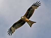
Birds of prey found within the area are buzzards, kestrels with the occasional red kite now visiting the area. Buzzards are the more common of the birds of prey and can be seen soaring above the hills mainly in pairs or in some cases in larger groups of six or even seven.
 |
 |
 |
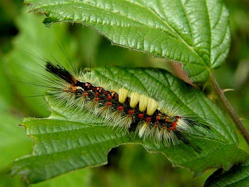
More unusual birds such as wood warbler, pied flycatcher, nuthatch and redstart can be seen here in the summer months, and again, careful management of the area ensures a healthy habitat for a multitude of flowering plants. Other plants of interest are the many mosses, fungi, lichens along with innumerable insects such as butterflies and moths. One moth which the caterpillar of seems to take a liking to these hills in the months of June and July is that of the Valpourer Moth. These caterpillars look like Chinese dragons. The main body is coloured black and covered in tufts of red and yellow fluff. Beware though if touched as these moths have a nasty reaction from the hairs and will give you a nasty rash.
In late August and early September especially on warm days flying ants swarm in there thousands or maybe millions round the summits. These then attract the swallows and swifts that then fly in elegant speed soaring through the air catching the ants in flight when also avoiding mid air collision with other birds. This also brings out the various local birds of prey such as the common Buzzards and the less seen Red Kites. These have been known to be quick enough to take swallows out in flight…?
 |
Section-9 Geology:-
Much of Central Wales is made up of Ordovician and Silurian marine sedimentary rocks, deposited in the Lower Palaeozoic Welsh Basin when Wales, as part of Avalonia, lay beneath a shallow sea on the SE side of the great ocean of Iapetus. On its far side lay Scotland and Northern Ireland, both part of the continent of Laurentia.
 |
The rocks laid down in the Welsh Basin are dominated by sequences of sandstone, siltstone and mudstone. Many of these sequences are referred to as turbidites, because they were deposited from turbulent, sediment-laden submarine currents, which flowed off the shallower shelf areas onto the deep floor of the basin.
Volcanic activity took place locally, notably in the Welshpool and Builth Wells areas. This activity produced basaltic lava flows and dolerite intrusions, some of which have been quarried for building stones and aggregates.
The Welsh Borderlands were situated on the margin of the Welsh Basin during Lower Palaeozoic times. This part of the basin was a shallow, warm shelf sea, teeming with life. Fossiliferous limestones, deposited in this sea, are now exposed in several areas hereabouts and are today quarried for aggregate and lime. They contain the remains of its inhabitants, such as trilobites, brachiopods, bivalves and corals.
The deeper water turbidite-dominated sediments occurring farther to the west are less obviously fossiliferous, but shale bands contain remains of free-swimming and drifting organisms such as graptolites, which sank to the sea-bed after they died.
The rocks of the Welsh Basin were deformed by the Late Caledonian (or Acadian) earth-movements as Iapetus closed and Avalonia collided with Laurentia, some 410-400 million years ago. One result was the folding of the Lower Palaeozoic rocks; another was the development of a strong cleavage in mudstones, which locally provided the raw material for the slate industry.
Regional scale folds in Central Wales include the Berwyn and Plynlimon domes, whilst trains of small folds are commonly seen in road-cuts and coastal sections. These structures record the deformation that accompanied the shallowing and final silting-up of the Welsh Basin in Devonian times.
 |
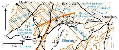
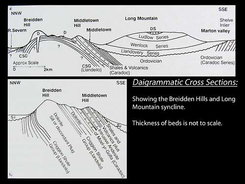
The Breidden Hills in Detail:
The Ordovician area of the Breidden Hills (mainly in Powys) lies about 14km to the north west of Shelve a separate geological area in the South Shropshire region. The areas are separated from the large mass of Long Mountain occupied by Silurian rocks.
The Ordovician rocks of the inlier are overlain unconformably by Silurian rocks on both the south east and north west sides, but the north west junction is complicated due to the line of the River Severn Valley Fault System which is entirely drift covered. The north east margin of the inlier is faulted against Upper Coal Measures.
A sequence of shales and volcanics up to 1,100 metres thick intruded by andesites and dolerites, including the famous well known Criggion dolerite, was originall mapped by a gentleman named Watts in 1885, and an anticline structure for the area, the Breidden anticline, has long been assumed. However, very little modern work has been done on this area until the time of the 1980’s. The sequence is fossiliferous and correlates with the upper part of the Shelve succession from the Rorrington Shales upwards, Upper Llandeilo to middle Caradoc (Soudleyan Stage) (Whittard 1979).
Dixon (unpublished Ph.D thesis, University College of Wales, Cardiff) recently studied the Ordovician Sequence in great detail and made detailed information which some of this text is based upon.
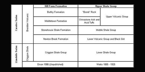 |
He worked out a new succession shown in the above table and correlated it with Watts (1885 – 1925).
The succession that Dixon worked out comprises of andesitic tuffs interbedded with dark shales and mudstones, and cut by andesitic and basaltic intrusions.
The Criggion Shale Group is black shales. The Newton Brook Formation and Stonehouse Formation comprise of silty shales interbedded with volcanic tuffs of submarine origin. The later Middletown Formation comprises course water-lain volcanic based breccias and finer tuffs which represent the emergence of island volcanoes, whose erupted debris covered the area and spread as far afield to the Shelve area as well. The overlying Bulthy Formation comprises water lain volcanic conglomerates, massive boulder and cobble conglomerates, the ‘Bomb Rock’ of earlier workers. The Hill Farm Formation marks a return to shale depositions with thin tuff horizons, and on fossil evidence in the area correlates with the Hagley Shales of the Shelve area. Another part Dixon has shown is how the volcanic material was laid down in submarine fans, often as turbidites, on the flanks of the volcanoes whose peaks would have risen well above sea level. He has also deduced that these volcanic rocks and sediments were then, while still unconsolidated and wet, intruded by the thick dome-like of Moel-y-Golfa andesite. Later dolerites of the Breiddens, including the Criggion dolerite, are remants of a complex of laccolithic, sills and dyke-like intrusions, of the late Ordivician, pre-Silirium age. However, they could be high level intrusions of the same age as the main deepest levels of the sedimentary basin, and it is certainly true that the thickest mass, the Criggion dolerite is entirely intruded into the Criggion Shales at the base of the sequence.
The Criggion dolerite has usually in the past been regarded as a laccolith intrusion which caused further anticlinal folding of the Criggion Shales, but the anticlinal nature of the Breiddens outcrop (folded at the end of the Ordivician period) is still not certain, and the dolerite could be a thick sill into a sequence which dips uniformly south east.
 |
During quarry investigations in 1980, 274 metres of dolerite were penetrated under Rodney’s Pillar on Breidden Hill, and the base not reached. The intrusion could be a discordant plug as the shales on the western contact do dip steeply west in places.
The Criggion dolerite is a well known road stone and also used on railways with its mottled green-blue appearance. It is a medium- to coarse-grained dolerite with plagioclase feldspar making up thirty-five to sixty per cent of the rock green pyroxene, epidote and small amounts of olivine (up to ten per cent).
The quarries on the north west side of Breidden Hill are very large and proceed in a series of steps to within a few metres of Rodney’s Pillar on the very top of the hill.
Because of the steepness of the hill, and the difficulties in maintaining haul roads to the top of the hill, the company working the quarry created a novel scheme in 1979 whereby a near vertical shaft inclined at 70 degrees 210 metres deep and 1.8 metres in diameter, was sunk from the top of the hill, and a near horizontal tunnel drilled in from the bottom of the hill 120 metres into the hill to meet the base of the shaft. Crushed stone from the top of the hill is now dropped down this vertical and transferred to conveyor to the outside of the base of the hill where it is then further treated. This ‘rock by-pass scheme’ as it is called, was the first one operating in the UK.
More information via this link: "Central Wales RIGS Group website"
Section-10 Accommodation and Tourism:-
Within close proximity of the Breidden Hills are the three towns of Shrewsbury, Oswestry and Welshpool.
Shrewsbury to the east is the largest of these towns. Being the county town of Shropshire in England Shrewsbury has lots of history to celebrate and is certainly worth visiting if you are ever nearby. Both Oswestry and Welshpool are much smaller and peaceful market towns with Welshpool in the Welsh county of Powys to the west of the Breiddens when Oswestry back in the county of Shropshire in England is to the north.
I shall give a small bit of information about each of these local towns starting first with Shrewsbury.
Shrewsbury:-
The town of Shrewsbury is one of the most historic and prettiest county towns you could ever wish to visit. The streets here are clad with black and white timber-framed buildings dating back to the Tudor period, a lovely medieval castle and the very impressive medieval church of St Mary’s. This mighty church now redundant and owned by the Churches Conservation Trust is famous for its medieval stained glass windows. Its spire, a landmark for miles around is said to be the third highest in England and rises over 300 feet above the great meandering curve of the River Severn.
The town also has other churches of great interest. One in paticular is the famous church of St Chads. This is one of only a few round naved churches within the UK. Another famous church is the beautiful Abbey Church to the east of town and near to the English Bridge.
"Shrewsburyguide - Website"
The Breidden Hills are within close proximinity to the famous South Shropshire Hills AONB which I created a Summitpost page for. As these are in the neighbouring English county of Shropshire and Shrewsbury is the county town there is a large amount of information available for Shrewsbury via the Summitpost page link below.
"Summitpost - South Shropshire Hills AONB"
Oswestry:-
Oswestry is much smaller than Shrewsbury but is still an interesting town to visit. Oswestry is situated in the north of Shropshire on the English and Welsh border. It is an ancient market town, whose strategic position as a 'frontier town' has given it a turbulent history.
Today the town serves as a vital market and shopping centre for Shropshire's north west and mid Wales. The streets are lined with many specialist and independent shops serving Oswestrys retailing needs.
"Visit Oswestry.com - About Oswestry"
Welshpool / Trallwng:-
The 'Welsh' prefix was added to this Powys market town's name in the year 1835 so as to distinguish it from the English town of Pool on the south coast in the county of Dorset. At its heart, a Victorian town hall presides over attractive 17th and 17th-century town houses. Powysland Museum charts the history of Powys, including an exhibition on the Black Death, which wiped out half of its population.
The town nestles in the upper reaches of the picturesque Severn Valley near the border of Wales and England. The bustling Market Town is surrounded by the rolling hills of Montgomeryshire and the glorious unspoilt countryside in Mid Wales. Traditionally an agricultural service centre, Welshpool possesses the largest sheep market in Europe and the feeling of a traditional hard working market town still remains today.
"Welshpool.org - Index"
Accommodation, Hotels, Bed and Breakfast:-
Many types of accommodation such as hotels, bed and breakfasts can be found throughout the above towns and local villages depending on what the services are that you require.
The easiest way to find what you require is to carry out a search in a search engine such as "Google" by adding the towns name and the type of accommodation you require afterwards.
For example in the search bar you could put:-
"Breidden Hills Welshpool Camping"
""
Section-11 Associated Summitpost Pages:-
Most website links are included in there relevant sections but this one is for the summitpost sites that have a page dedicated to them that have been mentioned in the above sections of this summitpost page.
"Cadair Idris"
"Pumlumon Fawr"
"Radnor Forest"
"Snowdon (Yr Wyddfa) and Snowdonia"
"South Shropshire Hills AONB"
"Stiperstones Ridge"
"The Arans"
"The Berwyn Mountains"
"The Pennines"
"The Wrekin"
Section-12 Access - Red Tape and Safety:-
Access and Red Tape:-
Although unlikely it is always worth checking the countryside access map provided by the Countryside Council for Wales (CCW) regarding whether or not any restrictions on movement in the area are in place.
These provide updates on any changes or closures that may effect your access to this area.
"Countryside Access Map"
"Countryside Council for Wales"
Open Access:-
Whilst most routes follow public rights of way or established permissive paths within The Breiddens, some cross areas of land where walkers have the legal right of access under The CRoW Act 2000 introduced in May 2005.
Open access land is detailed on Ordnance Survey map Explorer 255.
This access can be subject to 'restrictions' and 'closures' for land management or safety reasons for up to 28 days a year. Please respect any of these given notices.
 |
 |
For climbers, hill walkers and mountaineers, the British Mountaineering Council (BMC) runs a Regional Access Database, which holds mountain/crag specific information on matters of conservation and access, including issues such as nesting restrictions, nature designations and preferred parking.
"British Mountaineering Council (BMC)"
"Regional Access Database"
Safety and the countryside code:-
- Be safe always plan ahead and let others know of your whereabouts
- Leave gates and property as you find them
- Protect plants and animals, and always take your litter home
- Keep dogs under close control
- Always consider other people
Although unlikely there is still the chance for the weather conditions on The Breidden Hills to change and deteriate fast.
Whilst out on the mountains I have had fantastic sunny starts to the day finishing in grey damp very bad visibility mist and heavy rain. There are not many dangers present on these hills because no matter where you are in relatively short distance from roads and paths, but you should still always take care. The cliffs that overlook the large quarry on the north face of Breidden Hill or Rodneys Pillar are considerably dangerous as the drop is shear and well over 200 feet in places. These are fenced off, but people can still climb over them. Just be sensible...!
Weather:-
Weather forcasts are available on the internet along with TV channels and radio stations mainly at the end of the prime time news programmes.
Weather forecast links for the BBC's website covering a 5-Day and the next 24 hours in detail are given below.
"BBC Weather for Oswestry"
"BBC Weather for Shrewsbury"
"BBC Weather for Welshpool / Trallwng"