
-
 3611 Hits
-
 86.37% Score
-
 22 Votes
|
|
Mountain/Rock |
|---|---|
|
|
37.33212°N / 118.57299°W |
|
|
Trad Climbing |
|
|
Summer, Fall, Winter |
|
|
6584 ft / 2007 m |
|
|
Overview
The Owl is located in the Buttermilks area of the eastern Sierras. Like its neighbors Skin Diver, Wrangler Rock and Windy Wall, The Owl offers a number of routes on highly textured rock.
The Buttermilks is famous for its numerous boulders. Bouldering was invented as an off-shoot of rock climbing. During the past thirty years, however, bouldering has become an independent sport on its own. Boulderers come from thousands of miles away only to put themselves against many test pieces, in other words, boulder problems at The Buttermilks. On the weekends the number of boulderers can grow into hundreds. You are hard pressed to find a good parking spot much less a camp site.
Although the sport of bouldering dominates the area, a number of crags in The Buttermilks have been developed for the sport of cragging. The Owl is only one of several formations that draws attention from some of the boulderers. Bouldering is extremely taxing on the body, and even the best boulderers need complete rest, or at least a few easy, days. Climbing on larger but easier rocks provide the much needed respite. These formations also draw climbers of all ages who come only for the crags and not the boulders.
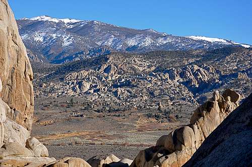
When climbers make the short and steep hike to the base of The Owl, they find themselves in a secluded narrow corridor made of several rock formations. This corridor is known as “Picnic Valley.” This charming valley, by its very nature, produces the best natural frame for the surrounding mountains and the Buttermilks valley. As you make the approach to The Picnic Valley the first formation you come to is The Owl. The Owl sits, like a watch dog, or watch owl in this case, at the enterance to this narrow corridor. Inside of the Picnic Valley, you are surrounded by other notable formations such as South Mount Klieforth and The Slab.
 |  |  |  |
Climbs of The Owl
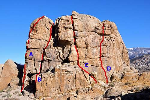
West Face of The Owl

South Face Face of The Owl
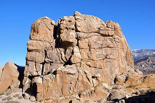
There are two faces with well established routes dating back to the seventies. As you approach The Owl via the “Frontside” parking and The Buttermilks hill, the first view of The Owl is a steep and well-featured face. This is the south face. Getting to the base of the climbs, however, is neither easy nor straight forward. The best approach seems to be from the right, east side, by going down and around several large boulders and hiking back up to the base of the south face.
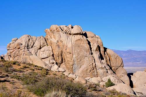
The approach to the base of the west face, however, is by far easier. As you enter the Picnic Valley the west face of The Owl is immediately to your right. The west face is steep and well featured. Both the south face and the west face of The Owl offer potential for more routes. If you have first hand knowledge of such newer routes please let me know.
| A | Jensen-Strassman, 10c, Standard rack, 3 bolts |
| B | Brown Helmet, 5.9, Crack, standard rack up to 4 inches |
| C | Extreme Levine Meets Godzilla, 10b, standard rack up to 4 inches |
| D | Vertical Smiles, 10c, standard rack up to 4 inches |
| E | Way Cool Tanks, 11a, run-out face, 5 bolts |
| F | Armadillo Crack, 5.8, standard rack up to 4 inches |
| G | Regular Route, 5.5, standard rack up to 4 inches |
 |  |  |  |  |
Camping Considerations
With a huge flux of climbers from out of town, I have noticed many tents and unsightly campsites in the parking areas. This practice has been tolerated by locals and authorities, so far. These climbers use the surounding areas, and sometimes the base of boulder problems, for going to the bathroom. I am afraid this kind of abuse will eventually impact this beautiful area. In addition it may result in restriction on access.There are many campgrounds nearby that can be used. Do your best to use the campgrounds, at least for extended stays.
The following links should help finding a good campsite:
Horton Creek Campground
Rock Creek Canyon
Inyo National Forest
Bishop Creek and vicinity camping
How to get there
The Buttermilks
From the town of Bishop California drive seven miles on Highway 168, also known as Line Street, to its intersection with Buttermilk Road. Take this dirt road for 3.5 miles to where you begin to see many large boulders to your right. There is a large dirt clearing here. This is the Frontside Parking.
Park in the Frontside Parking area. Looking up toward the crags, you can easily pick out The Owl. The Owl is in between Skin Diver and Wrangler Rock. A steep jeep trail heads straight up the hill. Take this trail to the top of the hill. At one point you will see another smaller trail heading to the right and toward The Owl.