
-
 4962 Hits
-
 85.87% Score
-
 21 Votes
|
|
Mountain/Rock |
|---|---|
|
|
37.33319°N / 118.57355°W |
|
|
Trad Climbing |
|
|
Spring, Summer, Fall, Winter |
|
|
6584 ft / 2007 m |
|
|
Overview
 Mount Emerson
Not to be confused with “The Slabs” in the Pine Creek Canyon area, The Slab is a rock formation in The Buttermilks area of the Eastern Sierras.
With its international reputation, The Buttermilks, affectionately known as “The Milks,” is known for its countless boulders and bouldering test pieces. Generally speaking, the sport of bouldering, as an off shoot of rock climbing, has gone through an evolutionary change in the past twenty years. Walking around The Buttermilks boulders, you quickly realize that many of the climbers have travelled for thousands of miles and from all corners of the earth to test themselves against the boulders here.
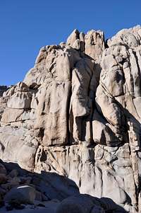
 east face of The Slab
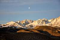
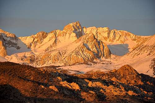
What makes The Buttermilks very special is not only the boulders but much larger rock formations such as Skin Diver, The Owl, Windy Wall, Wrangler Rock and The Slab, the subject of this page. In addition to all the above rock formations, The Buttermilks offers some of the most majestic views of the eastern Sierras. From here, you get the best views of Mount Tom, Four Gables, Basin Mountain, Mount Humphreys and Mount Emerson. It is common knowledge that the higher you are the greater the view of the mountains, and The Slab sits at the very top of the hill from the vast boulder fields of The Buttermilks.
 SW face-left side
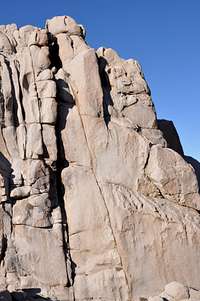 SW face-right side
As you do the approach hike up the steep hill, the mountain views become more and more grand. Upon reaching the top of the hill, you will see a narrow gully with a formation known as “The Owl” sitting at its entrance like a watch dog. This narrow valley is nick named “Picnic Valley” and is surrounded by rock formations on both sides. Our formation “The Slab” is a bit further up "Picnic Valley" and to your left.
Best seasons to climb
Even though the elevation of The Buttermilks is around 6500 feet, during the summer months the temps can still get into the 100’s during the day time. It is, however, possible to find faces that are not in direct sun and during the morning hours stay cool enough to do some climbing. Windy Wall would be a great place to climb during warmer seasons.
During the winter months you may have snow on the ground, but it can be very pleasant to climb on the south facing formations such as Skin Diver and Wrangler Rock.
My personal preferences are autumn and spring seasons. The temps are great most of the day and you have many formations to choose from.
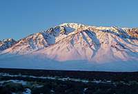 Mount Tom Mount Tom |  Picnic Valley Picnic Valley | 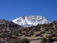 Basin Mountain Basin Mountain |  The Buttermilks The Buttermilks |
Climbs of The Slab
 east face
 SW face
The left half of the east face of The Slab is unmistakable as it is slabby and nearly featureless. It gets progressively steeper, however, as you go further to the right. The right hand face is heavily featured with large huecos and cracks. During the warm seasons, the east face could be a great place to climb in the afternoon hours. It stays in the shade and Picnic Valley seems to generate its own air current keeping the whole area cooler. During the cooler seasons, you can climb on the east face during the morning hours. In any case, the best part about climbing on The Slab is the seclusion it provides.
There are also a number of climbs on the south west face of The Slab formation. In contrast with the east face, the south west face is steep and convoluted. To get to this side of the formation, you need to hike up a steep and sandy, but short, gully on the left side of the east face. When you get to the top of this narrow gully and out of the Picnic Valley, the Sierras will open up in front of you. It will be hard to decide if you should climb or just enjoy the view. Most people do both.
Climbs of The Slab, The Buttermilks | |
| A | Got Yo Sequence Hanging, 10c, 3 bolts, Standard rck |
| B | The Slab Direct, 5.9, 1 bolt, standard rack |
| C | Totally Slabular, no rating offered |
| D | Bury My Heart, 11a, 2 bolts, and standard rack |
| E | Robin's Crack, 10a, and standard rack |
| F | Macho Homo, 5.9, 1 bolt, and standard rack |
| G | Stress Man, 10d, bolts and and standard rack |
| H | Marlboro Man, 10d, wide crack, pro to 6 inches |
| I | Cat Fight, no rating offered |
| J | No Fat Chicks, 10a, pro to 3.5 inches |
| K | Great Buttermilks Crack, 11c, pro to 2.5 inches |
| L | Bear Fight, 10a, standard rack, pro to 4.5 inches |
| M | Sharp's Scenic Stroll, 5.7, standard rack, pro to 3 inches |
Camping Considerations
 Mount Humphreys, another beautiful mountain view from The Buttermilks
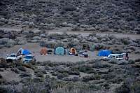 camping in bad style
There are many campgrounds nearby that can be used. Do your best to use the campgrounds, at least for extended stays. In addition to the nearby campgrounds, there are many unofficial campsites, some near running creeks, that can be used. In any event, camping in the parking areas is the worst to choose.
The following links should help finding a good campsite
Horton Creek Campground
Rock Creek Canyon
Inyo National Forest
Bishop Creek and vicinity camping

How to get there
From the town of Bishop California drive seven miles on Highway 168, also known as Line Street, to its intersection with Buttermilk Road. Take this dirt road for 3.5 miles to where you begin to see many large boulders to your right. There is a large dirt clearing here. This is the Frontside Parking.Park in the Frontside Parking area. Looking up toward the crags, you can easily pick out The Owl. The Owl is in between Skin Diver and Wrangler Rock. A steep jeep trail heads straight up the hill. Take this trail to the top of the hill. At one point you will see another smaller trail heading to the right and toward The Owl. The Owl is located at the enterance to a narrow gully known as “Picnic Valley.” The Slab is a short hike up this valley and on your left. To get to the south west face hike up a very narrow, steep and sandy gulley to the left of Slab’s east face.