Introduction
Fred has always wanted to climb in the White Clouds – the elegant white pyramid of D. O. Lee peak had caught his fancy and I always love going to places I’ve not been before. Since the White Clouds are over 400 miles from Spokane, we decided to set up a base camp at Ocalkens Lake and stay a few days, climbing as many summits as weather, time and bodies allowed.
The Hike In
![Hoodoo Hot Springs]() Hoodoo Hot Springs
Hoodoo Hot Springs![Trail Obstruction]() Trail Obstruction
Trail ObstructionWe left on a Tuesday, driving as far as Challis, Idaho, to spend the night. Very early the next day we drove to the Slate Creek trailhead in about an hour. While the Slate Creek Road is not marked from the Challis side, it’s not hard to find and in basically good shape – any passenger car can negotiate it. We hiked from the trailhead along the trail past Hoodoo Hot Springs and around the end of the mine tailings. Continuing up hill, we encountered a second USFS sign about no motorized traffic. Heaven forbid they put up a real trail sign! At this point, one sees small downed trees and should go that way. Some jackass has purposely attempted to obliterate and
![WCP 6]() WCP 6 from the trail
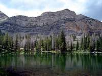
WCP 6 from the trail![Ocalkens Lake]() OCalkens Lake
OCalkens Lakeobstruct the trail by falling small and medium sized trees across it. We thought the downed trees indicated a rerouting of the trail and continued on up the old road. At the first switchback we realized that this was the trail up to Hoodoo Lake and not the Slate Creek trail. After some searching, we finally found it. One can either stay parallel for the 1/4 mile of downed trees, or one can go a short ways up the old road to Hoodoo and then do a long, angled traverse towards Slate Creek to intersect the trail (how we did it) Despite the initial confusion, we arrived at Ocalkens Lake 2.75 hours later.
About ¾ of the way there, Fred suddenly starts swearing in his best Montana style. He had left that day’s lunch in the cooler in the car. Then it dawned on me, that I had left ALL my lunches of cheese and landjäger (a German style of dried salami) in that cooler as well. A quick inventory of the trail snacks I had brought confirmed that while I wasn’t going to starve, I was going to be on limited rations. Oh, well.
WCP 6
![WCP6]() WCP 6 from Ocalkens Lake
WCP 6 from Ocalkens Lake![WCP 6]() WCP 6 from Noghorn Basin
WCP 6 from Noghorn BasinUpon arriving at the lake we found a gorgeous spot along its eastern shore and set up camp. After getting organized and filling water bottles, we headed up the trail to the pass into Iron Basin. From there we hiked up the initially treed slopes and then talus of WCP6 and within the hour were standing on its summit with great views of the entire Ocalkens/Bighorn Basin. It allowed us to scope out the next day’s approach to D. O. Lee and WCP 9 peaks.
![Panorama of the Bighorn Basin]() Panorama of the Ocalkens-Bighorn Basins
Panorama of the Ocalkens-Bighorn BasinsD. O. Lee and WCP 9
![Bighorn Basin]() Bighorn Basin
Bighorn Basin![WCP 9 and D. O. Lee]() WCP 9 and D.O. Lee Peaks
WCP 9 and D.O. Lee PeaksThe next morning we set off early and followed the trail to Iron Basin as far as the last switchback. From there we proceeded south across meadows to a large rock outcrop. Below this outcrop a game trail led into the Bighorn Basin. What a fabulous place! We walked through its flowered meadows and then turned east up the gently sloped meadows to the base of the west buttress of WCP 9.
![WCP 9 and Lee peaks routes]() Routes
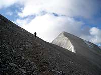
Routes![D. O. Lee Peak]() Approaching the ridge
Approaching the ridgeNow the work began. We scrambled up the loose talus slopes, following more solid rock ribs when possible to the base of the rocky outcrop that is in the middle of the buttress. From the bottom of the rocky outcrop we chose to cross to the low point of the ridge connecting Lee and WCP9, following a game trail. The first part was miserably loose, but eventually the trail became better as we got closer to the notch. From there we continued along the ridge towards Lee, following a game trail. Shortly before the summit, the ridge became more solid and some fun but very short Class 3 climbing brought us to the summit. There was no snow, except one remnant just above the notch, where we left our packs. The summit register, placed in 2006, showed an average of 8 parties climbing Lee Peak each year, mostly from of the Big Boulder Lakes side.
![Lee Peak]() Fred on Lee
Fred on Lee![User Profile Image]() Moni on Lee
Moni on Lee
We hiked back down the ridge and trooped over to the summit of WCP 9, which we reached from the summit of Lee within an hour. From WCP 9 we had good views of Calkens peak. We decided that we didn’t like the west side approach to the notch between WCP 9 and Calkens. We’ll tackle that summit from the east side some other trip. On the way back down WCP 9’s south ridge, we discovered a very well established game trail that leads from above the ridge’s low point over to the top of the rocky outcrop on the west buttress. It was far better than the trail we had used to get to the ridge and would recommend it for the ascent. From the base of the buttress we decided to descend through the gullies on the east side of the lake and were rewarded by seeing a herd of 18 bighorn sheep on the slopes at the base of WCP 9. Six hours after leaving camp, we were back and spent the afternoon lounging about and exploring the lake shore.
WCP 7 and 8
![First light on WCP7]() WCP 7
WCP 7![North Ridge route on WCP 7]() North Ridge Route WCP 7
North Ridge Route WCP 7While on the summit of WCP 9, we decided we really liked the look of WCP 7 and saw that traversing from its summit along the very long ridge and up WCP 8’s north ridge should be feasible. Leaving early again on the third day, we once again hiked to the pass to Iron Basin. There is a small basin just west of the pass, from which you ascend the vegetated slopes and rock outcrops on WCP 7’s north side.
![WCP 7 north ridge]() North Ridge WCP 7
North Ridge WCP 7![Approaching WCP7]() Approaching WCP 7
Approaching WCP 7 You reach a broad talus filled basin and cross it to the west to a ridge. From there, the ridge crest is a nice combination of Class 2 and 3 climbing all the way to the summit. The summit register that was placed in 2007 showed only the one ascent in 2007 and one in 2008 – we were the first for this year.
![Traverse WCP 7 to WCP8]() Traverse to WCP 8
Traverse to WCP 8![WCP-8 Northwest Ridge]() On the NW ridge of WCP 8
On the NW ridge of WCP 8The ridge to WCP 8 looked very long and the last bit a bit daunting, but no harder than what we had just climbed. We quickly descended the easy south ridge of WCP 7 and walked across the meadows to a little summit that is halfway between WCP 7 and WCP 8. We chose to hike low around this summit, as Fred was afraid that it would cliff out. This proved to be wrong – we should have gone directly over this knob. The traverse of the loose talus slopes low down was unpleasant and time consuming. It took a while to regain the ridge. We continued along the ridge to a very distinct game trail that crosses from the ridge west to a subridge. From there we climbed directly up the face between the 2 ridges, coming out again on the north ridge and then continued following the ridge to the summit block, arriving there about 3 hours after summiting WCP 7 and 5 hours after leaving camp. There is no summit register on WCP 8 and I imagine it gets climbed only every few years.
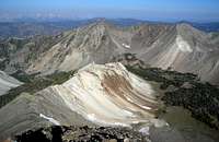
![View west from WCP-7 summit]() Return route: down to the basin on the left, around the white ridge and up Iron Basin
Return route: down to the basin on the left, around the white ridge and up Iron Basin
While traversing to WCP 8, we decided that descending the meadows to the west would be a good way to go rather than going back over WCP 7 or descending one of the steep, loose, unpleasant looking couloirs into Bighorn Basin. There were 2 basins, but the northerly basin looked like it led most directly to the end of Iron Basin. That proved to be the case – at this basin’s west end we found the Iron Basin Trail (which is very poorly defined and easily lost). While going this way may have taken more time, it was such pleasant walking through grassy meadows and fields of flowers, that I would recommend this as a descent route. High up on the slopes between WCP 6 and WCP 5 we saw a mountain goat. 9.5 hours after leaving, we were back in camp, very pleased with that day’s adventures.
Aftermath
The next morning we packed up camp and headed out – pleasantly tired from 3 fine days in the mountains. On our way to Missoula, we stopped in Salmon for a very large lunch – but the White Clouds Diet must work – I seemed to have lost about a pound!


Comments
Post a Comment