

-
 7055 Hits
-
 87.76% Score
-
 25 Votes
|
|
Mountain/Rock |
|---|---|
|
|
44.10503°N / 114.64697°W |
|
|
Mountaineering, Scrambling |
|
|
Spring, Summer, Fall |
|
|
10557 ft / 3218 m |
|
|
 WCP-8 from the northeast.
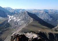 From the north
Overview
 The summit
The precipitous northeast face of White Clouds Peak #8 forms the headwall of Bighorn Basin to its north and its less steep southern slopes rise over 2,000 feet above Warm Springs Creek.
Like on the other peaks in the area, the rock is not suitable for technical climbing and the feasible safe routes are on the ridges. WCP- 8 has 3 ridges. Lopez describes the south ridge as Class 3 and accessed via the Warm Springs Creek Trail. We climbed the peak via the long northwest ridge which we reached by descending the south ridge of WCP- 7. The northwest ridge was mostly Class 2 with bits of Class 3. The east ridge appears easily doable once attained, but we have seen no reports of ascents nor did we get a very good a look at it.
The summit is an interesting small block of black rock which we thought might be a huge cairn when we viewed it from Bighorn Basin. There was no summit register as of July 2009 so we do not know how often the peak is climbed. It is more remote than its nearest neighbors and based on how often they are climbed we suspect that it is seldom visited.
Getting There
From the north: From the 7/8 saddle
The shortest approach from the north with a trail is via Slate Creek to Ocalkens Lake.
The Slate Creek Road leaves Idaho 75 about 22 miles from Stanley and about 26 miles from Challis. It is about 8 miles to the trail head and the road is normally passable by passenger cars.
There is adequate parking at the trail head. As of July 2009, there are no signs about anything except that motorized vehicles are not allowed. The trail / old road is obvious past the hot spring and the mine tailings. However, be aware that the trail up Slate Creek to Ocalkens Lake has been deliberately blocked and / or obscured at its junction with the trail to Hoodoo Lake. Someone has dropped a bunch of small to medium sized trees across it. At first, we thought that is was an indication that the trail was rerouted or something and went too far up the Hoodoo Lake Trail. We found the Slate Creek Trail by dropping down from the Hoodoo Lake trail toward Slate Creek. We suspect that this may have been done to keep motor bikes out?? Or....?
From the south:
The Warm Springs Creek Trail passes along the south slopes of WCP -8. This trail can be attained in numerous ways. Probably the shortest is described by Sean on his South Ridge Route page for D.O. Lee Peak.
Routes Overview
The White Clouds are covered in Idaho, A Climbing Guide by Lopez.Because of the poor rock, the safest most feasible routes in this area are the ridges. WCP-8 has three ridges. Lopez describes only the South Ridge. We climbed the Northwest Ridge.
The east ridge is unknown to us and we could find no reports of any climbs. It appears to be about the same as most other ridges in the area. Access to the D.O. Lee / WCP-8 saddle from Bighorn Basin looks to be very difficult. The saddle could probably be reached by descending the west ridge of Lee, or possibly from the south.
South Ridge, Class 3. This is the only route described by Lopez. He says to leave the Warm Springs Creek Trail where the stream draining the south slopes of WCP-8 crosses the trail and follow the stream upward to about 9,000 feet. At that point, go west to the south ridge and climb it to the summit.
 On the NW Ridge
 On the NW Ridge
Northwest Ridge, Class 2 & 3. We climbed this ridge on July 31, 2009. It is mostly Class 2 with bits of Class 3, but it is quite long. From the saddle between WCP-7 and WCP-8 climb nearly to the top of Point 10,244. Just below the top and to the west (climber’s right) there is a good goat / sheep trail leading to the first notch in the ridge. From there, follow the ridge going over some small towers & humps and around others. With care, nothing harder than Class 3 need be climbed.
Summit Views
Click on images for larger view, captions, and peak identification.  East East |
 Southeast Southeast |
 North Northwest North Northwest |
Red Tape
NoneCamping
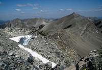
 Ocalkens Lake and WCP-8
There are several established camp sites along the Slate Creek Road just below the trailhead.
There are excellent campsites at Ocalkens Lake.
We have not been in the Warm Springs Creek valley and do not know what might be available there.