
-
 10098 Hits
-
 81.68% Score
-
 14 Votes
|
|
Mountain/Rock |
|---|---|
|
|
44.13046°N / 114.64765°W |
|
|
Hiking, Mountaineering, Scrambling |
|
|
Spring, Summer, Fall, Winter |
|
|
10256 ft / 3126 m |
|
|
Overview

Situated above the spectacular Slate Creek basin on the east, and the Iron Basin on the west, WCP-6 is an easily accessible peak in the northern section of the White Cloud Mountains. In a region of plentiful peaks for scrambling, WCP-6 is one of the easiest. At Ocalkens Pass, a short Class 2 scramble over loose, but stable rock quickly leads to the summit.
Ridge traversing in the White Clouds is a truly rewarding experience. From WCP-6, one can ridge scramble to the more prominent WCP-5 (Class 3), then continue west onto WCP-4 and then possibly Watson Peak. Another option from Ocalkens Pass is to climb the challenging NE side of WCP-7, then continue on along a tower studded ridge to WCP-8 and D.O. Lee Peak.

Access to the WCP-6 area is from the Slate Creek drainage from the north, or the Iron Basin / Warm Springs on the west side. At the Slate Creek trailhead there's a jeep trail that goes by Slate Creek Hot Springs, an improved and documented soaking site. Further on, the jeep road passes an abandoned mine site, complete with collapsing buildings, an enormous scorched earth pile completely devoid of vegetation, narrow gauge rail, and mine shaft. Evidence supports that this site has been improved and abandoned over the years, from the early 1900's until the 1980's. Like much of the central Idaho mountains, the White Clouds area is riddled with old mine sites and evidence of the extraction industry. New legislation looks to end any future exploits by designating this area as Wilderness.
Just beyond the mining site, the road becomes a single track trail through a pine forest along Slate Creek. At Ocalkens Lake, the trail takes a sharp NE turn and climbs to Ocalkens Pass before dropping into Iron Basin. Cross country travel south of Ocalkens Lake takes the eager explorer into the Bighorn Basin and the head of the valley. The Boulder Lakes Basin lies on the other side of this headwall.
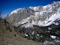
The nature of the rock around WCP-6 is of loose, but stable scree on the south slopes. The sheer north side of WCP-6 drops off steeply and most likely could only be ascended safely in the winter. The rock in the area is small (golf ball) to medium (football) scree. The former is difficult to ascend, but can be easily dry skied down. The later is easy to ascend, but difficult to descend. Pick and choose the proper lines and travel is straight-forward. Large sections of solid rock are mostly devoid in this region, unlike some neighboring ranges. Technical rock climbers may not be interested in this area, but any runner, scrambler, or biker would be challenged by the limitless aerobic workout on these open slopes.
Getting There

From Stanley, drive east toward Challis on ID-75 for 20 miles past Sunbeam Hot Springs. Turn off at the Slate Creek Sign and follow a decent road on a slate roadbed for 8 miles until the parking area. Along the way, there are several private ranches, and the locals attempt to keep the road plowed in the winter. Interestingly, Challis Idaho receives less precipitation and snowfall annually than Boise does. This is due to the rain-shadow effect that (west to east) the Boise, Sawtooth, and White Cloud mountains provide. Given this fact, one might find the White Cloud Mountains accessible for a longer period of time than some neighboring mountain ranges.

Fred Spicker - Aug 2, 2009 10:26 pm - Voted 10/10
AccessAs of July 2009 the Slate Creek road is in good shape and easily passable by passenger cars. Be aware that the trail up Slate Creek to Ocalkens Lake has been deliberately blocked and / or obscured at its junction with the trail to Hoodoo Lake. Someone has dropped a bunch of small to medium sized trees across it. At first, we thought that is was an indication that the trail was rerouted or something and went too far up the road. We found the trail by dropping down from the Hoodoo Lake trail toward Slate Creek. We suspect that this may have been done to keep motor bikes out?? Or....?