Three Fourteeners in Four Days (and a Thirteener)
![Mount Darwin]() Three Fourteeners In Four Days
Three Fourteeners In Four Days
On September 12th, 2010, Charybdis took me by suprise and decided to bring me with her to scramble some Fourteeners in California. Okay, so maybe we talked about it a little before-hand. Nonetheless, I was still excited about the idea. The list included Mount Whitney, Mount Langley, White Mountain Peak, and Mount Tyndall. There were also a couple Thirteeners (Mount Solomons and Black Giant)that would be included in a loop from North Lake, over Lamark Col, down Darwin Canyon, up Evolution Basin, over Muir Pass, Down LeConte Canyon, up to Dusy Basin, over Bishop pass and down to South Lake. We had eight and a half hiking days to work with (11 total) and over 100 miles. One of these mountains, Whitney, was something of an icon and I wanted revenge on it after failing to summit it a month prior. Not to mention another week in Charybdis' wonderful company!
We planned on taking out Mount Langley from Cottonwood lakes via New Army Pass, then the next day we would go to the north along the JMT/PCT to Tyndall, acclimate, climb then go to the base of Whitney for our final peice of the puzzle. Next we would do a separate trip for White Mountain Peak as a day hike. Finally, and most anticipated, would be the three day journey over Lamark Col, Evolution Basin, Muir Pass and Bishop Pass. (Which I think we agree is the most beautiful part of the Sierras) Things did not go as planned, but I think it was for the best. We skipped Tyndall, realizing that we were trying to have fun, not kill ourselves and freed up a day to add to the other trips. We also eliminated Black Giant from the original line-up because we couldn't properly identify it when we got to its base (we had forgotten the map in the car).
Day one: getting there
.
Death Valley
One thing I would like to emphasize about our trip that made the buisiness of climbing these mountains difficult even though we took the easiest routes is the awkward elevation swings that we put our bodies through. On day one we flew into Las Vegas (3,000'), dropped down to Death Valley (-125' and stayed a while for photos), drove over a pass at 5,000', dropped down to 2,000', went over another pass at 6,000', dropped down to Lone Pine (3,700') and drove up to Whitney Portal (8,700') to get shuttled to Cottonwood Lakes TH at 10,000'. Our bodies were going through extreme differences in oxygen intake before we even started hiking.
Day two: Mount Langley
We started at Cottonwood Lakes TH before sunrise and slowly worked our way over to New Army Pass. The moon-like landscape was really neat but unfortunately we forgot the camera back in the car at Whitney Portal. We topped the pass around 10:00 AM and headed for the class 1/2 scramble. I had this preconceived notion that I would be fine having summited Rainier and having hiked the majority of the John Muir Trail the month before. (I will post that TR on NWHikers.net when I can get all the details written.) But as nature would have it, I did not retain any of my previous acclimation and didn't properly acclimate the previous night, comming from below sea level. The very easy walk to the summit was for me a terrible struggle. It was nowhere near as exposed (except for on the summit) as the Whitney trail was (I turned around on Whitney before because I was getting altitude sickness and the exposure was increasing). That didn't stop me from feeling like vomiting with each inhale. Charybdis seemed to fly up without trouble and she seemed very cheerful on top. All I could do was try not to throw-up. I signed the summit register, called my little brother (the infamous Josh Lewis) from her satellite phone, and turned around. Every step on the descent added clarity to my conscious and I could feel the oxygen enriching my body. The descent back to old army pass (an abandoned pass between New Army and the summit) was sorta fun because this time of year it was just gravel that you could plunge-step. We went as far as we could go before we started to run out of day-light and it became obvious that there wouldn't be time for Tyndall the next day.
Day three: Guitar Lake
It felt strange comming back to the area that I had visited only a month prior that at the time back then I thought I'd never see again for at least a few decades. We dropped down to 8,000' and gained a small pass where we tried out some pilaf then continued to Crabtree Meadows. Here was a strange feeling. I knew we weren't far from civilization, yet it looked so remote and peaceful. We made it to Guitar lake before sundown and debated whether or not to continue upwards. We would gain some acclimation time, but we would have limited water. It is dry season and there is absolutely no water on the west face of Mount Whitney. We decided to continue on looking for water sources as we went. There were a few nice ponds above the Hitchcock Lakes that made a convenient camp at about 12,000'. It had occurred to me that this was the highest camp I have ever made. It was most apparent when I tried to sleep as my heart was racing even when I was at rest. I drank some water to dilute my blood and ease blood pressure. After an hour or so I managed to sleep. It was cold up there but we were bundled up in down coats in cozy bags under clear, beautiful starry sky. I wish things like that didn't come to an end. As hazard would have it, our camp was invaded by mice. At one point, the critters were comfortable enough with me to crawl on my head! Then my friend's air mattress popped. We were on sand, but she didn't get as good of sleep as I did...
Day four: Mount Whitney
We got an alpine start, even though we only had 2,500' to gain. I took it really slow, being very cautious about my approach. Last time I rushed and got a headache that killed the deal. This time I went way slower than what felt comfortable, took a break even when I didn't want one, drank plenty, and smiled often. Another group was taking our route up the west side of the trail and we kept passing and getting passed. One of them, Jan Fancher, I owe a great debt of gratitude. She allowed us to use her camera on the summit and on the way to Trail Crest to document this story. As we went up it was interesting to watch the west face of Hitchcock Mountain look farther and less imposing. As we ascended the wind picked up as well. I could see a storm system comming from the West and I wasn't sure what it would do. I was steadfast in my pace though. I would rather turn around and enjoy myself than push it to the top and get stuck in bad weather. It never came to that. Just severe wind. When we all arrived it was hugs and smiles. Many people had come here from other parts of the world and it was interesting to see the variable demographic. Jan took our photo and I took hers. Charybdis allowed for a satelite phone call (a tradition we continued) and I signed the neatly organized summit register. Apparently there is an easy button up there. Compared to my last attempt on Whitney, this one was easy; and it was very enjoyable as well. We descended a ways and bumped into Jan one more time. She allowed me to take a few photos of the gullies that drop away to the east down to the Portal. After this we attempted Muir peak. It is supposed to be an easy class 3 scramble but it looked to me like another class up and it was frighteningly exposed. Combine that with the heavy winds and we knew it would be suicide. I'm glad I got to give it a look though.
![Myself in front of the Whitney Hut]()
![View from Whitney trail down to Owens Valley]()
Going down the 99 switchbacks (it's not just a legend: I've counted them), was somewhat more difficult than going up the other side. Then descending to the portal felt even more difficult. Something about losing 6,000+' does something not only to your feet, but morale as well. I felt real dumb for not having a camera because I saw some of the most beautiful scenery as clouds swirled over Whitney's pinnicles and cast shadows on Owen's valley below. Just for fun we weighed our packs at the station (a measley 18 pounds) and went strait for the restaurant for some fries. I managed some pictures for the sunset as we drove out to Lone Pine for the night where I had an amazing burrito from a taco stand.
Day five: White Mountain Peak
I don't know why we didn't think we had tortured our bodies enough the previous day. It's beyond me. For some reason I was excited to climb (as in walk very leisurely) up White Mountain Peak, the third tallest Fourteener in California. Plus it would be interesting to drive through and observe the famous Bristle Cone Pine, the oldest living tree in the world. The hike is an easy seven miles with only 2,000' of elevation gain. The catch was, we had slept at a motel at the southern end of Lone Pine which was about 3,000' and now we were at 12,000' and we would walk above that altitude all day. I knew it would be a laborious walk. It was strangely cold out even though there wasn't a cloud in the sky. Not so strange I guess, when I consider the altitude. The trail is really an abandoned 4x4 road that leads to an observatory and research station. We checked out the facility and met with one of the staff, chatting breifly. The rest of the day was a slow slog. It was driving Charybdis nuts so that at the end she almost quit. But somehow she held out and I was able to make another victory phone call. My brother had become annoyed at this point from all my summit calls and so I agreed to discontinue the new tradition before it took root(and before it drove Josh insane). I had my highest meal up here (not inculding airplanes) and tried to take a panorama of the Sierras.
![White Mountain Peak]()
![Satellite phone call from White Mountain Peak]()
Comming back down was nice and slow as there are a few ups and downs that no doubt add several hundred feet to the elevation gain. We were not alone on the summit and we met up with our company several times. We were concerned about where to camp for the night and they were gracious enough to tell us where to find a good spot that just so happened to be where they were going. The drive was much more intense than the hike as there were many hare and birds comming out of the bushes that I had to dodge. Luckily, no animals were hurt in the making of this adventure. We ate well and slept with a healthy conscience.
Day six: Best Western and Lamark Col
One thing I think Charybdis has that my other hiking partners can lack, is an amazing understanding of the power of luxury. She made it a point to set up a reservation at the Best Western in Bishop so that when we were done with our big loop from North Lake to South Lake, we would feel completely relaxed and feel like we earned it. It was difficult not to just end the trip right there, but we both knew how much better it would feel after completing our goal and we wanted to see the Evolution Basin again. She was very particularly set on Lamark Col and Darwin Canyon. They were new to us both and I looked forward to the experience. First thing was first, though; we had to go to Eric Shcatt's Bakery to get a great breakfast.
Driving to South Lake somewhat spoils any would-be hiker with some of the best scenery any highway can offer. I did my best to capture some of it as it whirred by at 50 MPH. It felt exciting to be visiting an area we had been to before and liked. Even better that we would be getting there via a new route. I had heard that this was mostly off-trail travel from the upper lake to the col. Well, apparently there is a small trail that goes all the way to the Lamark Col but we missed it and ended up doing some very lose class 2 boulder hopping. Our mistake was following the trail for too long. We slowly found our way to a sandy moraine at the foot of an old snowfield covered in suncups. We attempted to climb them, but it was much too tricky. We set up camp in the soft sand and then, Charybdis was full of fire and gave the Col one more shot before dark. She almost made it and when I saw what she was doing, I realized she had found the correct route. I ran up it to get a feel for it (something she had taught me) for the next day. It was actually pretty straight forward and I couldn't see why I didn't notice it before. I got to the col just in time to watch the beautiful sunset. I had stupidly left the camera in the pack so I could only get a shot of its afterglow in a pond at the lowest point in the sand.
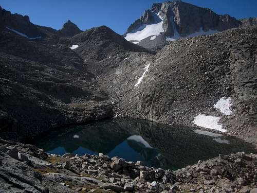
Day seven: Darwin Canyon and Evolution Basin
The next day I started breakfast as soon as the stars began to disappear. I wanted every ounce of daylight. The previous night had frozen our water (except for some that I kept with me in the tent). It had also frozen the pond, which now had birds eating off of it.
We packed up quickly and made short work of the Lamark Col, admiring the Darwin Canyon on the other side. We would follow a series of connecting lakes out to Darwin Bench, the remnants of a large glacial moraine that scours the bedrock with interesting formations. Somewhere on the decscent I begin to realize that my feet are in pain. It wasn't blisters, but some kind of skin condition that caused clotting and rash. I assume it was from wearing mountaineering boots for too long. I put on double socks and just bit the bullet to continue the trek. The reflections on the lakes made a nice distraction and it was interesting navigating around the lake system.
![Mount Darwin]()
Evolution Basin proved to be just as beautiful as when I had last seen it and I spent most of the time gaping at it. We came across a father and son who were camping nearby and doing our loop in reverse. We gave them our extra maps in exchange for some good conversation. Charybdis was taking lots of photos here of the vegetation which was just barely starting to show signs of fall colors.
We took our time heading up to Muir Pass, looking at the peaks change form as we past them and admiring the wild topography of this ice-sculpted rocky land. It was different from the last time I was here in that the sky is completely clear this time. It was fun to go to a certain place on the trail and remenisce about what conversations we had with who. One couple that sticks out in particular, was an Australian couple who were through-hiking the PCT in sections. We only met them for one day but they were very delightful and easy to talk to. It was their daughter's thirtieth birthday and Charybdis offered to give them a miracle phone call. We managed to keep in touch since then. As we neared Muir Pass, we decided to have dinner early while there was still a good water source. The Hut made for a perfect place to take great sunset photos. We also met a Fireman from Fresno who had done a very difficult loop somewhat similar to our own.
Day eight: Solomons and Dusy Basin
![Ionian Basin]()
![Solomons Register]()
We started off the day with Hot chocolate and a climb of Mount Solomons (mmm...). It was an easy class 2 scramble but we were running out of steam and the day was new. The summit view was well worth our struggle and we basked in the rising sun. We could not agree on which mountain was Black Giant and so we had to scrap that plan to avoid getting unnecessaryily lost. This freed up much needed time to descend to the valley below. It was about a 3,500' drop and we needed to gain that much more to get into Dusy basin later in the day. At first it was nice and serene. But after a while of descending down the same steps I had been gaining only a month before, I began to notice the heat. It must have been hot. I drenched myself in a waterfall and dried out in just a few minutes. It actually started to affect my mood in a negative way so I distanced myself from my companion to avoid sending undeserved frustration her way. I remember being angry for some weird reason. I don't normally get angry and especially not here. I think it was the sun and my skin's inability to sheild against UVA/B rays. It was driving me nuts. Eventually she caught up and I was suprised to see her upset by the beautiful weather too! We both cooled heads at the creek and headed to the ranger station where we met Ranger Rick Sanger (who is a.k.a Sick Ranger). It was real pleasant comming across him again because we had run out of fuel that morning. He made fun conversation and willingly gave us some spare left over fuel he had. Going up to Dusy Basin on the way to Bishop Pass is a very steep section of trail. There are waterfalls going over slabs of rock here and you can see your progress by comparing the mountainside to the west which seemed to change rapidly. After hours of puffing away, we finally made it to Dusy Basin and set up camp nearby some other hikers who were headed the other way. Charybdis was lucky enough to snap these awsome photos just before the camera ran out of power.
![Dusy Basin]()
Day nine: Bishop Pass, South Lake and Best Western
I woke up early and we tried to boil as much water as possible. We ended up using all of the spare gas to make breakfast. It was a shame the camera was gone, but most of the best splendor tends to be elusive. We hiked on to Bishop pass, which to me seemed to come very easily. The exposure going down was different but by this point I had become used to it. The mountains surrounding us blanketed the place in shadow. It was strange to see in the morning hours. When we saw somebody in the distance, Charybdis reminded me that we needed a ride to North Lake so she had me flag him down for a ride. He wasn't the right choice but eventually we came across a group of Doctors out of San Berndino. Not only were they wonderful conversationalists but they gave us a ride all the way back to our car at North Lake free of charge (we tried to pay them but they refused!). It's great to know that there are such compassionate people in the community.
From there we packed up and headed to the Best Western. I did some pool rehab, while my partner relaxed with a magazine. My feet were killing me but it felt so good to enjoy the luxuries after earning them. We dined on mexican food that night and the next day we flew home. I'd like to thank Charybdis for all her charity on the adventure. I offered what energy I could to the expedition, but she is the awsome person that made it happen.


Comments
Post a Comment