Page Type Page Type: Trip Report
Location Lat/Lon: 36.90975°N / 118.78222°W
Date Date Climbed/Hiked: Sep 6, 1978
Activities Activities: Hiking
Seasons Season: Summer

“The cold wind blows,
And gods look down in anger,
On this poor child.

Why so unforgiving and why so cold?
Been a long time crossing bridge of sighs.”

The Clutches (I)

September 7

Exhausted, I stumbled away from the creek and nearly collapsed. I was drenched and water poured off me and my backpack. The waist-belt of my pack was unbuckled causing it to hang painfully from my weary shoulders. I leaned over with my hands on my knees trying to catch my breath and unexpectedly brought up the contents of my stomach onto the rocks and gravel. Was this from over exertion? Or terror? To this day I'm still not sure.

It was while I was bent over, heaving away, that I noticed water running out of the leather case that was dangling from my neck. My camera!! I stood and began to open the case. I noticed blood on my shaking hands. My fingers and palms had numerous scrapes and minor puncture wounds on them. I looked back at the thin log spanning the creek...

...I was instantly dragged to a horizontal position- face up under the log. I somehow hung onto it- gripping, clutching with both hands. My arms raised over my head- my hands in a death grip. I bounced on the surface of the creek like a flag flapping in a strong wind.  I could see the sky through the arching tree branches above me. My pack beneath me was mostly under water. The current was relentlessly attempting to tear it violently from my shoulders. My hands began to ache, but I knew that if I lost my grip, it would have meant getting swept down the creek and into the  Kings River to a cold dark terrifying death...

I miserably poured the water out from inside the camera case. Ominously, a darker shade of water was leaking out from inside the camera body itself. I felt even sicker, but I didn't throw up anymore.

“Oh, goddammit!!!” I looked around to see if anyone had seen my idiotic Crown Creek stunt and its embarrassing aftermath. As expected, I was completely alone. My throat was burning. The taste in my mouth was awful. I knew I was lucky to be alive, but then I obsessed on my camera. I couldn't really afford it, but I bought it anyway (credit). It was a 35mm Pentax SLR. My only hope was to get it to a repair shop as soon as possible.

Suddenly, I'd lost all interest with this trip. It was only the second day of what had been planned as a ten day trip through Kings Canyon National Park-  a vast section that I'd never visited before. But, now I wanted to quit. Run home. Tail between my legs.  Except... This trip was not over. Not by a long shot.

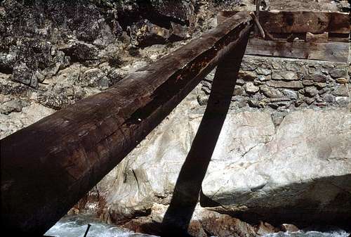
I looked back at Crown Creek- spanned by that f**ken log. There was no way I was going to try to recross that. I realized an unpleasant truth:  Like it or not, I was committed. There wasn't going to be an easy way out. I was in the clutches.

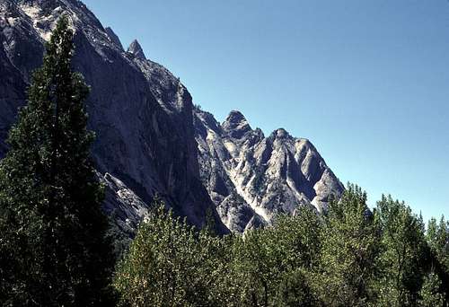
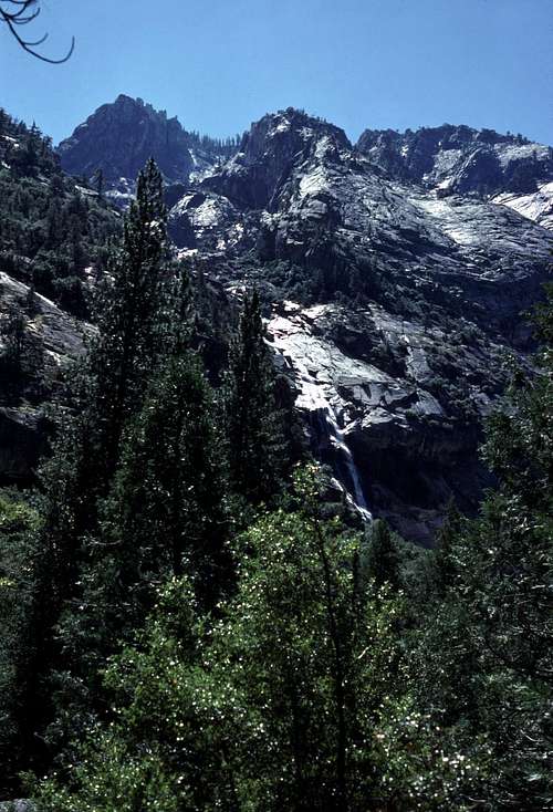
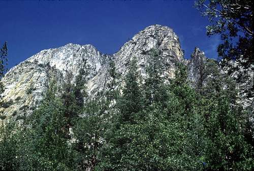
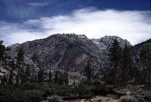
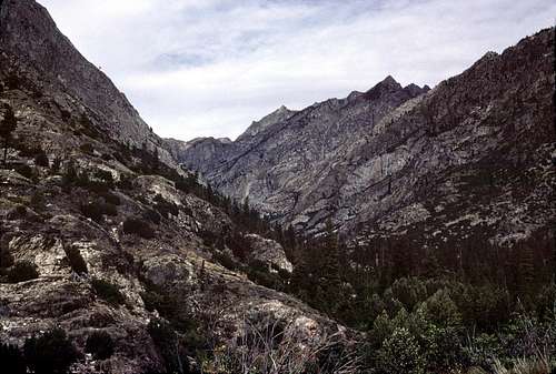
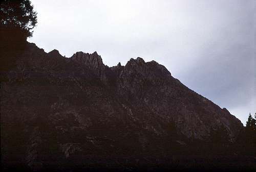
The bright afternoon sun was suddenly eclipsed by a cloud. I looked around shivering- water still running off my clothes. A circle of wet sand had formed around my boots. I needed a campsite. I looked around, but didn't see anything. My eyes were drawn upward by a monolithic wall of granite directly above me. Tehipite Dome seemed to hang over my head. The late afternoon sun was gleaming off its sheer cliffs. Clouds had begun to obscure the uppermost portions. Across the huge flooding Kings River were the incredible cliffs, turrets, and gorges of Crystal Creek and the Gorge of Despair.

Less than an hour before, it had all seemed so sublimely beautiful- almost like a fantasy world. Now Tehipite Valley had become a trap that I'd willingly walked into.  I suppose there's a lesson to be learned here. Something about  'dangerous stream crossings' and  'knowing when to turn back'.

Idiot!

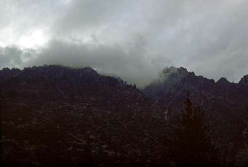
 As the layer of clouds began obscuring more and more of the sky, the interaction of light and shadow were creating some incredible photo ops. I would have reached for my camera, but...

What was I going to do with this thing, now? This 4 or 5 pounds of dead useless weight. Jam it into my already heavy backpack? Or just keep wearing it around my neck- like a lodestone? I thought seriously about flinging it into the Kings River, but decided that that would surely be a stupid thing to do. I'd already done enough stupid things this afternoon. Maybe it would still be repairable when I got home. Whenever that would be.

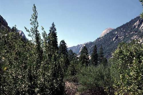
My plan to find a better campsite on this side of Crown Creek had, apparently, failed. There were a few, but they were all under water. The fire rings rising out of the muddy torrent was the only evidence of their existence. Everywhere else was too choked with boulders and brush for camping. I was wet, cold, and frustrated as I buckled my waist belt and began to hike up the canyon along the trail. My soaked pants stuck uncomfortably to my legs as I hiked. I thought it would be just a short distance to a decent campsite and then I can start to dry out.

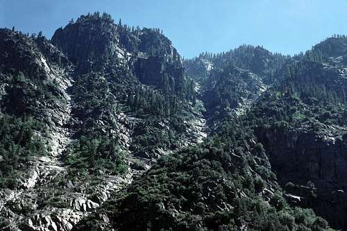
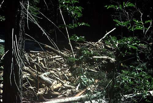
This portion of the trail follows the base of the cliffs at the foot of the mighty Tehipite Dome. Along this narrow rocky corridor- between cliff base and flood plain, I could see that almost the entire floor of Tehipite Valley was flooded. In the middle of the valley, there seemed to be a couple of thickly wooded islands. Looking carefully, I could see that the river was flowing through the trees of these 'islands'- not around them. An intense display of nature's awesome power. If only my camera... 'sigh'.

My despair increased when after a short time the trail began to climb and wind its way through steep jumbles of boulders. I'd reached the eastern end of Tehipite Valley without coming upon a single good campsite. Damn! If I continued up the trail there would be very little chance of finding a flat space large enough for my tent. But on I went as if in a trance, walking like a zombie as the trail wound its way through the boulders and chaparral. I'm pretty sure that I was still in a mild state of shock.

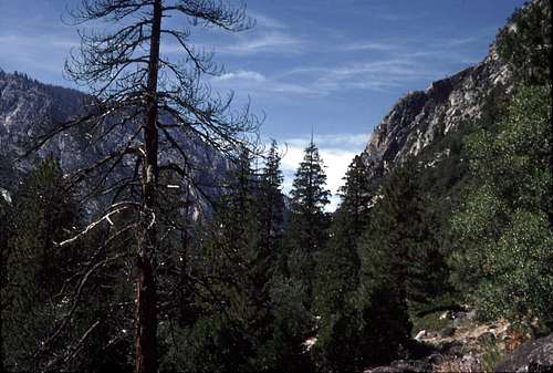
Finally, after a mile or two, I came to a small grove of trees and a flattish area close to the thundering river. For the first time since Crown Creek, I struggled wearily out of my wet heavy backpack and set it down.

I opened the compartments and began pulling stuff out. I was happy to find the the top third or so of my pack was fairly dry. This would include all my food and my warm outer layers. The lower half had my spare clothes and down sleeping bag. The clothes had gotten pretty wet. What I was already wearing was starting to dry out, so I didn't bother changing. I pulled my goose down sleeping bag out of the stuff sack and was happy to find that the water had only slightly penetrated a few isolated areas.

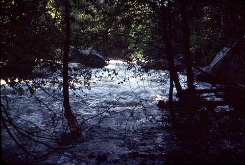
I ate a much needed “Slim Jim” as I wandered around looking for the best place to set up my tent. It was then that I realized that maybe this wasn't such a great place after all. A nice grassy area that had initially attracted me, turned out to be too rocky. Worst of all it was uncomfortably close to the Kings River which was thundering heavily down a short cascade. I looked at the sky- gray with ever lowering clouds. The threat of rain had been on the increase ever since... my mishap. What if the river floods even more? I didn't want to be this close to what was already a raging torrent.

According to the map, I was just downstream from the next major tributary: Blue Canyon Creek. I hoped that there might be a better site there. Somewhat replenished from my snack and a bit relieved that my gear- especially my sleeping bag- wasn't as wet as I'd imagined, I packed up and got ready to move out. When I reached for my ruined camera, I noticed orange water running down the rock it was sitting on. It looked almost like blood, but I knew it was the emulsion chemicals from the roll of film that was still inside the camera. Shit!

I rewound the film and opened the camera. Half a cup or so of orange water poured out. That film contained all the pictures I'd taken in Tehipite Valley and the flooding river west of Crown Creek- now lost forever.

In a brief moment of angry frustration, I took the roll of film and did something that I've since greatly regretted. I flung it under a large boulder that had a cavernous gap between it and the ground upon which it rested. It was full of dead leaves and twigs and, for all I know, some of those rattlesnakes that are reputed to be abundant in this canyon. I guess I hadn't done enough stupid things that day after all. Sorry, everyone. Sadly, I'm no John Muir.

I was disappointed, though not very surprised, to find that there were no campsites along the trail all the way to Blue Canyon Creek. When I arrived there and saw how massive and turbulent this creek was, I became consumed with fear. It was just too damn soon to be facing yet another dangerous stream crossing. Whatever confidence, courage, or even cockiness that I'd brought with me to the mountains on this trip was left downstream on the other side of Crown Creek.

A thick wet log- about 15 feet long and just barely clearing the surface of the creek was my only crossing option. Water from the creek had splashed onto the top of the log in a couple of sections. Those sections looked kind of slick and I didn't trust myself to walk across. I would have to straddle it and scoot on my butt. This situation was frighteningly similar to what I'd just been through back at Crown Creek.

The increasing clouds hid the setting sun as I stood there hesitating and pondering all those 'what ifs'. It was getting dark. I had to get going!
 
Grow a pair and just do it!” an inner voice screamed. Wasn't this the same voice that got me in trouble in the first place? Did I trust it? Did I trust myself?

“Shit!” Like before at Crown Creek, I unbuckled the waist belt of my pack and sat on the log- straddling it. I was glad that it was just high enough above the creek so that my feet wouldn't dangle into the torrent. It was thicker and more stable than the Crown Creek log, but it vibrated and shook uncomfortably due to the power of the raging water just below. Immediately downstream from the log, the Kings River rumbled violently through house and truck sized boulders. Like before at Crown Creek, there would be no opportunity to stop myself from being pitched out into that massive flooding river if I fell into the creek.

And, just like at Crown Creek, when I was about half way across, my pack decided to shift suddenly to the side. “F**k!!

...I was rapidly losing strength! I had to do something fast! I somehow turned my body over so I was now face down- Crown Creek rushed by just a foot or so below my face. I remained mostly horizontal as I was bounced and violently jerked by the current. It was like hanging onto the tow rope on the back of a fast moving speed boat. My aching hands were locked onto that log for dear life...

This time, at Blue Canyon Creek, the log remained stable as I used both hands to clutch it with all my waning strength. The only consequence was a near cardiac arrest.

At last, to my great relief, I reached the far side and struggled to my feet. Darkness was closing in. I buckled my waist belt and continued on- pleading with the mountain gods for decent place to camp. They must have forgiven me for my earlier transgressions with the roll of film and my other feats of stupidity, because after a short bit of hiking, I finally came to an adequate campsite.

This site was also uncomfortably close to the river, but I was too tired and desperate to care anymore. At least it had a flat clean spot for my tent and even a small fire ring (which I didn't use). There was just enough light left in the evening to be able to set up my tent without using my headlamp.

After my camp was set up, I went down to the river's edge to get some water to boil to make my evening meal and coffee. The river was still in a full state of flood- the sky now completely clouded over. I built a cairn at the very edge of the water to serve as a makeshift gauge so I could keep track of the water level.

By the light of a candle, I ate some kind of freeze dried crud for dinner. But, under the circumstances, it was some of the most delicious crud I ever ate. I hadn't had a meal since breakfast at Crown Valley earlier that morning. It felt like many days ago. God, what a day! I felt cut off, isolated and utterly alone. For me, those are usually good things, but not this time. Seeing just one other person on the trail would have gone a long way toward improving my morale.

As I ate, I wondered how many more swollen tributaries were in store for me as I continued up this miserable canyon. I carefully unfolded the wet map that I still had in my shirt pocket. There were three: Alpine, Rattlesnake, and Dog Creeks. None of them looked like they drained anywhere near the huge areas that Crown or Blue Canyon Creeks did. I relaxed a little.

Further study of the map revealed nothing that I didn't already know. There would be no easy way back to the car. There weren't any practical ways of climbing out of this canyon cross country until Goddard Creek was reached. Unfortunately, Goddard Creek was known to be a very difficult bush whack and there would surely be more dangerous stream crossings up there.

The only logical way back to my Rancheria Creek trailhead was to keep going up the Kings River and over Muir Pass. Once I got to Simpson Meadow and was back on the maintained trails, surely there would be bridges constructed over the largest streams. I just hoped that they wouldn't be washed out by the floods. From Muir Pass, I could travel cross country through what looked like easy terrain to the Hell For Sure Pass Trail and begin to work my way across the region near Courtright and Wishon Reservoirs.

Ha! This had been my original plan anyway, with a side trip to visit the Palisades. Well, for the moment anyway, the Palisades were out. I was in escape mode.

September 8

I slept until the sun was lighting up the trees outside my tent. The sun? I peeked outside and was pleasantly surprised to see a cloudless blue sky. My spirits were instantly lifted and I put on my still damp clothing.

I instantly decided to take advantage of the sun and spend as much of the day as needed to dry out my wet clothes and gear. While water for coffee and oatmeal heated over the stove, I began draping various garments over nearby bushes, rocks and even the roof of my tent.

I discovered, to my annoyance, that my toilet paper had gotten soaked as well. Damn! I carefully unwound several squares at a time and hung each strip on low hanging branches all around the camp. It looked as though my campsite had been the victim of a high school prank.

I was pleased to see that the water level of the flooding river had receded a small amount from the tiny cairn I had built the night before. A few more sunny days and maybe everything would return to normal.

And then there was my camera... Was it as bad as I thought? Yeah, almost certainly. Precision mechanical devices really don't like getting wet, but I decided to remove the lens and open the back to let it dry out. During the process, I took a clean bandana and wiped up as much of that orange liquid as I could. When it appeared to be clean, I cocked and released the shutter only to find new droplets of water on various internal parts. I then wiped these off before cocking and releasing the shutter again. I repeated these steps over and over again using different shutter speeds. I hoped that the water would be forced out of the complicated mechanisms and that the preexisting lubrication would stay intact.

Eventually, after more than an hour of cock, release, and wipe, the inside of the camera appeared completely clean. The electronic light meter seemed to be working normally, so, what the hell, I decided to load a roll of film and begin taking pictures again. The trouble was- in that pre-digital world- that I wouldn't know for sure if it was working properly until I got the pictures back from processing a week or so after returning home.

[Note: It turns out that my camera was working just fine, but I'd accidentally adjusted the ASA to the wrong setting which resulted in many of the pictures taken during the next couple of days turning out too dark (as you will see). Drat!!]

While the rest of my gear dried, I took a short hike down canyon with my camera to test it. I found a spot a short distance from camp where I could see the Tehipite Dome and some of the turrets of the Gorge of Despair.

Gorge of Despair
From just above Blue Canyon Creek.

Down the Middle Fork Canyon
From just above Blue Canyon Creek. Tehipite Dome is on the right.

Noon rolled around and I was pleased that much of my gear and clothing was now mostly dry. I even had enough toilet paper dried out to last a few days. (Whew!) I decided to pack up and head up canyon hoping to make some progress toward Simpson Meadow.

I ate a handful of 'Gorp' for lunch and then started hiking up the canyon. It was a beautiful day with great scenery. The huge walls of the Middle Fork of the Kings River canyon were unbelievably impressive. My spirits were pretty high and, yes, I was becoming tempted to put the Palisades back on my itinerary. Well, I decided to decide when I got to the JMT at Palisade Creek.

Slide Bluffs
View looking up at a portion of the Slide Bluffs.

Flood
Typical view of the Middle Fork of the Kings River.
 

There were many long sections of the trail that were still underwater due to the swollen river. In those areas I was often forced to detour cross country through long stretches of steep boulders often covered in dense brush and thick forests. It was terribly exhausting and my high spirits began to erode. I'm pretty sure I know, at least partially, what Frank Dusy must have experienced on his trailess exploration up this canyon a century or so earlier.

Cliffs on the North Wall
The north wall of the canyon.

Log Jam
Log jams were fairly common along the Kings River above Tehipite Valley

Not only was travel very difficult, but I was worried about the possibility of encountering rattlesnakes since this canyon had a reputation for having a high population of them. My progress was slowed somewhat because I was constantly scanning the ground and the boulders I was climbing over for them.

I remember one spot in particular, where I had to jump down from the top of a large mossy boulder onto a flat rock about three feet below. A large dead tree trunk lay at the foot of the boulder I was on blocking part of my view of where I was to land. Based on my experience on previous hikes, it seemed to be a likely place for a snake to hide. After hesitating for several moments, I leaped and whirled around to look at the ground near my ankles that I couldn't see from above and... there was nothing. As usual. In fact, for all my precautions, I never did see a single snake during the entire hike up the canyon.  So much for 'reputations'.

Slide Bluffs
Looking south at a portion of the Slide Bluffs. Middle Fork of the Kings River canyon.

It was in the late afternoon when I finally had enough and decided to camp. I found a nice wooded area near the trail that was high above the flooding river. After more freeze dried slop for dinner, I dragged my scratched, beaten and abused body into my sleeping bag.  I was still at least a mile from Simpson Meadow. I hoped that tomorrow wouldn't be more of the same.

September 9
I woke up rather late that morning. I wasn't planning to travel that far anyway. Maybe just to the upper part of Simpson Meadow. I was still pretty sore  and weary from all the unexpected cross country travel the day before.

Some high clouds had moved in during the night. I hoped it wasn't the harbinger of another storm. The floods were receding nicely and the last thing I needed was more rain. But, even if it did rain, it probably wouldn't impede my travel too much. Once I got to Simpson Meadow, I would be back on maintained trails. That, hopefully, meant bridges constructed over the major streams.  Right?

As I ate a quick breakfast I gazed out at the brown turbulent river thundering past my camp. I shuddered at the thought of having to cross the Kings River without a bridge. Luckily, there was a substantial bridge just downstream from Simpson Meadow according to one source that I'd read before the trip.

I was on the trail by mid morning. It didn't take long for the soreness and stiffness in my leg muscles to iron out and I began to feel pretty good. The trail was in better shape along this stretch than it had been further back down canyon. It was high enough above the river so that there were no flooded or washed out sections. Soon, the narrow walls of the canyon begin to widen out and I knew I was getting closer to Simpson Meadow.

View Down Canyon From Near Simpson Meadow
Down canyon from near Simpson Meadow.

What a great day!  Just two days earlier I was in the grip of an ordeal, but now this could turn out to be one of my best trips.

The trail along this section moved uphill and away from the river. The going was pleasant through an open forest of scattered conifers. Once in a while the view opened up and I could definitely see that I was getting closer to the river crossing and Simpson Meadow.

Eventually, I reached a junction with a vague looking trail that continued northeast along the north side of the river. The main trail doubled back toward the south and the river itself. As I approached, I got a glimpse of the crossing. I could see something spanning the river through the trees.

To my horror, when I arrived, I saw that the bridge had been all but completely destroyed. A single log was all that was left. It was about 45 feet long and less than two feet in diameter spanning the river about 15 to 20 feet above the surface. At this point, the entire flooding river that I'd been following was confined to a narrow channel spanned by this... log. The anchorages of the bridge showed evidence that there had once been two other logs spanning the river in parallel perhaps fastened to each other by some flat decking to allow horses to cross, but now...

Just downstream I could see one of the missing logs sitting partially on the bank of the river. Jeez! Did the flood reach this height?? Couldn't be. Maybe there was a monster log jam carried down by the flooding water that tore the bridge down.

There was a handwritten note tacked to a  remnant of the handrail:

“Cross at your own risk!
It may be easier (safer)
to ford about 1 mile upstream.
x___________
-NPS Ranger”

Ford upstream? In this flood? Maybe I should wait a day or two for the water to recede a bit more, but would that be enough time? The thin high clouds that had arrived that morning were quite a bit thicker now. What if more rains were on the way? I took off my pack and sat down on a rock in front of the sign. I stared at it long enough to memorize it. Maybe there were other options.

For the second time since Crown Creek, I got out my maps and tried to figure out an alternative route back to the trailhead and my car. The same three unattractive possibilities presented themselves as before:

  1. Go back the way I came. I thought about Crown Creek and shuddered. What if it was still just as full as it had been the other day? That was a credible possibility due to what appeared to be another approaching storm.
  2. Stay on the north side of the Kings River and head cross country up Goddard Creek to the Hell For Sure Pass area and exit. This would surely be a rough and difficult route. I had a strong feeling that I would be jumping out of the pan and into the fire.
  3. Be brave! Suck it up and cross the goddamn log! Then continue up the Kings River as planned.  “Being brave”, and “sucking it up” might be how I got into this fix in the first place. But at this point, it seemed to be least unattractive choice.
I looked again at 'option 3', the log. It was scary, but not difficult. Just walk across the log and I'll be home free. I clenched my fists,  filled myself with resolve and put on my pack. Yes. Just walk across. Go! Determined, I marched the few steps to the log and... stopped cold.

God dammit!! My mind became flooded with those 'what ifs' again. A half dozen unpleasant scenarios played in my head. Most of them started with me tripping or slipping on the log. There was one where the log rotated under my weight. The endings were mostly the same: Death by drowning. Dragged underwater and trapped among automobile sized boulders. The worst one was where I struggled to crawl out of the river with a compound leg fracture- bootless,  packless and bleeding- more than 30 or 40 difficult miles from help.

Compared to the mighty river thundering by below, the log looked like a toothpick. There were knots and a few nails sticking out that I would have to avoid. I looked down beyond the log at the river rushing by. It made me feel dizzy.  Geez Louise!

I don't mind admitting that I was kind of scared.

I stared across at the opposite bank. If only I could will myself to be over there. I'd be home free. Shit, shit shit! But... okay. Let's have some rational thought, alright? If that log were resting on the forest floor, I'd have no trouble with getting on and walking its length. Maybe I can just pretend.

I held my ice ax in front of me horizontally at belly level like the pole of a tight rope walker. Shit! Okay, go!  Don't think about anything but the log. Focus. I stepped onto the log and started walking. I was doing it!  Well, sort of. It was like an out of body experience. I concentrated on the surface of the log. The rushing river below became a background blur. After all, I was just on a log on the forest floor, right? Not too fast and not too slow. Just focus on the log and walk normally. Watch that nail! Don't stumble. Doing great!

The Log
The log crossing at Simpson Meadow. I took this after my crossing.

At last, I reached the opposite bank and stepped off the log onto terra firma. What a relief! I did it! Suddenly, I felt hungry. I took off my pack and had some cashews and raisins for lunch while I watched the terrible current sweep past under that log I'd just crossed. Soon, it was time to continue my journey. What's next, I wondered.

Simpson Meadows is situated in a wide relatively level section of the Middle Fork canyon. Many sections of the trail are shadeless and surprisingly warm for such an area so deeply ensconced in the middle of a major mountain range. I hoped to see others here, but there was nobody but me.

As I hiked, I saw a small building off to the left well away from the trail. I knew that it was at one time a ranger station- now abandoned. I decided to check it out. When I got closer, I saw what seemed to be a huge beehive hanging from the front of the building surrounded by... well bees. Lots of them. Not wishing to seek out more trouble, I decided to return to the trail and continue on.

Beyond Simpson Meadows, the trail makes a long contour around the northwestern foot of Windy Peak and begins a long gentle ascent toward the junction of Cartridge Creek and the narrow gorge that the Kings River flows down through. This part of the route had even less shade than Simpson Meadows and the going was often hot and dry in spite of the increasing clouds.

The view to the northwest included the mouth of Goddard Creek canyon- one of my possible- and rejected- alternate routes for my escape. I was quite glad that I wasn't at the moment fighting my way up there. I was fascinated by the endless talus slopes on the southern face of Mount Woodworth to the north. Dr. Bolton Brown must have had a lot of 'fun' up there.

Up Goddard Creek
Looking up Goddard Creek from Simpson Meadow.

Mount Woodworth
Mount Woodworth from Simpson Meadow

It was during that long dusty section of trail between Windy Peak and Cartridge Creek that the clouds really began to thicken and threaten. I had been apprehensive about the crossing of Cartridge Creek, but I was relieved to find a sturdy wooden bridge. Just beyond the bridge, and uphill from the trail, I found a pretty nice campsite. I decided to call it a day.

East of Simpson Meadow
Looking up canyon toward the confluence with Cartridge Creek.

From Cartridge Creek Camp
Looking up the Middle Fork canyon from near the junction with Cartridge Creek.

Weather doesn't usually affect my moods, but given all that I'd been through so far on this trip, I was kind of depressed and apprehensive about what this next storm would bring. More flooding? More bridge washouts? More dangerous crossings? I tried to enjoy the spectacular views of  the great canyon that surrounded me, but I kept worrying about what lay ahead.

Looking up Cartridge Creek Canyon
Looking up toward the Great Cliffs from my camp.

Great Cliffs
A botched photo of a storm building over the Great Cliffs.

At least the rain held off until after I'd eaten, cleaned up and had all my gear stowed for the night. Not for the first or last time on this trip, I found, myself wishing that my partner, Dave, had come along. My last human contact had been a young couple backpacking near Crown Valley three days ago. I felt as though I was the only person in the entire park. Everyone but me had sense enough to stay home.

By the time I snuggled down into my sleeping bag and shut off the light, it was full on night. The rain was coming down in earnest. It was certainly one of the blackest nights I'd ever experienced. I pulled my hand out from inside my sleeping bag and held it right in front of my face and wiggled my fingers. Yeah, it was just like the old cliché- I couldn't even see my hand in front of my face.


Comments

No comments posted yet.


Parents 

Parents

Parents refers to a larger category under which an object falls. For example, theAconcagua mountain page has the 'Aconcagua Group' and the 'Seven Summits' asparents and is a parent itself to many routes, photos, and Trip Reports.