
|
|
Mountain/Rock |
|---|---|
|
|
45.53300°N / 7.36090°E |
|
|
Trad Climbing |
|
|
11870 ft / 3618 m |
|
|
What's new
- 6 September 2005 – Start up of the page. Thanks to Antonio Giani, contributing with the information taken from his page of Torre del Gran San Pietro and to Livioz for useful information and valuable correction of the English.Overview
Close to the Torre del Gran San Pietro , the highest summit of the Apostoli range (a subgroup of the Gran Paradiso Group ), there is the Torre di Sant’Orso (3618 meters). This mountain (by the way, Torre di Sant'Orso could be translated: Tower of Saint Bear) is dedicated to the patron saint of Cogne (1534 m), the village where many trailheads to the Gran Paradiso Group begin. The Torre di Sant’Orso is located at the Northernest sector of the Apostoli range: the face, in front of the Valeille, is completely rocky, the one descending towards the Valnontey and facing to the Gran Paradiso. View of Torre S.Orso and close summits
It is considered, by the normal route, a easy ascent (the Torre del Gran San Pietro is more difficult and tiring) through a wonderful alpine environment, white glaciers and spectacular views of the Gran Paradiso and many wide glaciers (i.e the Ghiacciaio della Tribolazione). On the West side of the Torre del Sant’Orso there is the Coupé di Money glacier divided by the Paganini ridge (3440 m) from the nearby and wider Money glacier; to the East the Valeille, with its smaller glaciers (Sengie and Valeille glaciers).
The first ascent by E.T. Compton, G. Yeld together with F. Pession, A. Pellissier and L. Guichardaz has been performed in 1892 climbing the West side. By the same side, the first winter ascent was later, in 1935, with E. Deffeyes, T. Ortelli and G. Rossi.
 |  |  |
Getting There
In the following the text of the section has been taken partly from the description made by Antonio Giani for the Torre del Gran San Pietro . The main starting point is the village of Valnontey (1666 m), which name is the same of the most known side valley of the Vallon di Cogne (Cogne Valley).- From Torino, Milano, etc: Highway A5. Exit in Aosta Ovest. Drive to the the village of Aymavilles (I would suggest, better after the ascent, a visit to the Charrer’s wineyards of Aymavilles). Continue in the direction of Valle di Cogne.
- From Switzerland: through the Grand St. Bernard Tunnel or the homonym Pass. Drive to Aosta, then follow Courmayeur direction on SS.26. Just after Sarre, turn to the left, in the direction of Valle di Cogne.
- From France: through Mont Blanc Tunnel or Petit St. Bernard Pass. It isn't necessary to enter in motorway A5, you can drive through the road SS.26 Aosta direction. Before arriving at the village of Sarre, follow the sign and turn right towards Valle di Cogne.
After Aymavilles, the road SP n° 47 crosses the villages of Vieyes, Epinel and Cretaz and after about 20 Km arrives at Cogne (1534 m). From Cogne, by bus or by car, till the village of Valnontey.
 |  |  |
Route overview
The normal (and easiest) route to the summit is from the W side, starting from Valnontey.According to “ Guida dei Monti d'Italia - Gran Paradiso parco nazionale " (1980, CAI/TCI), there are two harder and not common alternatives, both from the Malvezzi Antoldi bivouac in Valeille: from the N side (rocky wall and ridge) and from the E-NE rocky wall.
Taking into account the difference in height from traihead to the summit (about 2000 meters), a two days trip is usual for the ascent to the Torre del Sant’Orso. A night in the Money bivouac (2872 meters) is recommended before the final climb of the second day. Nevertheless, with good weather condition and starting at early morning from Valnontey (not later than 05:00 A.M., depending on your legs), well trained climbers could reach the summit and come back by the day.
 The route to the bivouac
FROM VALNONTEY TO MONEY BIVOUAC
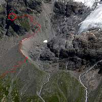
From the village of Valnontey (1666 m), where you can park the car and the last bus stop is located, you have to follow the easy and flat trail going up along the valley. After the pleasant hamlet of Valmiana (1729 m) continue, always gently uphill, up to a fork at 1800 m (00:45 h). Turn left, following the trail to the Money huts (Casolari di Money), which begins to rise steeply. After 01:00 – 01:15 h a long traverse at about 2250 m brings one in view of the Money Huts at 2325 m. Shortly before reaching them, turn left (there is a clear indication of the direction) and go towards the ridge of the moraine of the Coupé di Money glacier. Following the ridge of the moraine to its end, cross towards left a field of talus and broken rocks;
 The final step before the bivouac
The bivouac, placed at 2872 meters (03:45-04:00 hours from Valnontey) is in a very panoramic position in front of the Gran Paradiso central chain.
Drinkable water may be found at a short distance above the bivouac. A chain helps to reach it. Pay caution.
FROM BIVOUAC TO THE SUMMIT
Descending for a little from bivouac by the same trail of the ascent , cross the trail from the Money huts. Continue along the moraine till about 3100 meters and then on the easy Coupè di Money glacier with low risk of crevasse (keep the left of the glacier) up to the Coupè di Money (3393 meters).
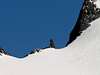
Then, at first keeping the Dito degli Apostoli on your left, ascent a steep snowy slope (max 35°) up to a shoulder (3605 meters) than to the summit by a not difficult climbing on about 20 meters of rocks (04:00 – 04:30 h from the Money bivouac). Depending on the seasonally condition of the glacier and in presence of ice, before reaching the shoulder, could be convenient to turn left, climbing the West rocky side up to the N ridge (about 50 meters) and then towards the summit (UIAA II, quite exposed).

 |  |  |  |
When To Climb
From mid-June to September, there are the best climbing condition. For updated information on the glacier condition (crevasses, ice, traces and so on) contact Ezio, owner of the Ezio Sport shop in Cogne (Tel. +39-0165-74204).You can get meteo information at the official site of the Regione Valle d'Aosta
Red Tape

Inside the P.N.G.P. (Parco Nazionale del Gran Paradiso) a long list of actions is forbidden, such as a) the dogs are not allowed, b) you can not leave the trail, c) you must leave wild animals alone and flowers and mineral where they are, d) you must take away your wastes, e) no music and in general disturbing noise in the park are allowed. Anyway, decalogue is present on all the trails before the border of the park.
No fees are due.
Camping
Camping is forbidden except in case of emergency, over 2.500 meters, from darkness until dawn.The most appropriate support point is the Money bivouac.
In case of need (i.e. crowded bivouac) sometimes it is possible to ask the keys of the Money huts (Casolari di Money) to the Home for the old Don Bosco (suggestion of an unknown priest met on the trail to Money bivouac). The home is located in Cogne along the road towards Valnontey.
In the valley, there are three camping sites close to Valnontey village.
 |
Books and maps
Two books in Italian:- E. Andreis, R. Chabod, M.C. Santis "Guida dei Monti d'Italia - Gran Paradiso parco nazionale" Club Alpino italiano/Touring Club Italiano (1980);
- G. Bona “In cima. 78 Normali nel Gran Paradiso”. SUCAI Torino. BLU Edizioni (1998).
Map:
- IGC Istituto Geografico Centrale. 1:25000 Gran Paradiso, La Grivola, Cogne, n°101
Miscellaneous Info
Useful information:- Society of the Guides of Cogne Tel. 347/9473526 - 328/1373728
- A.I.A.T. Cogne Gran Paradis via Bourgeois n° 34 Tel. 0165 - 74040 - Internet site: www.cogne.org - E-mail: aiat@cogne.org
- Ezio Sport - via Bourgeois n° 64 Tel. 0165-74204
- Internet site: www.aineva.it
Useful numbers:
- Mountain rescue (Cogne): Tel. 3482685406
- Civil protection of the Val d’Aosta: Tel. O165-238222
- Avalanche Bullettin: Tel. 0165-776300
- Valle d'Aosta Meteo Tel. 0165-44113
- Health Rescue Operative Unit: Tel. 118