They are two rocky teeth (3.644m the Southern one and 3.651m the Northern one) between the Torre di S. Orso (3.618m) to the North and the Torre del Grande San Pietro (3.692m) to the South. They aren't clearly detectable from Cogne built up area or from the lower Valnontey, they become visible while ascending to the Herbetet small houses. From its summit a wonderful scenery on the Gran Paradiso.
Trattasi dei due denti rocciosi (3.644 m Meridionale e 3.651 m Settentrionale), tra la Torre di Sant'Orso (3.618 m) a Nord e la Torre del Grande San Pietro (3.692 m) a Sud, non distinguibile dall'abitato di Cogne (1.534 m) e dalla bassa Valnontey (1.666 m), però ben visibile durante la salita ai Casolari dell'Herbetet. Dalla sua cima si gode un panorama eccezionale sul Gran Paradiso.
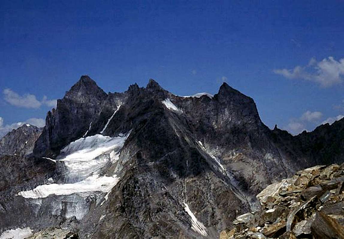
Together with the Gran San Pietro and the Torre di Sant'Orso, even further to the North and overlooking the Colle Coupé de Money (3.383/93m) with its characteristic Dito degli Apostoli (Apostle's Finger; 3.434/9m), which stands out both above the Glacier Coupé de Money and Valnontey (to the West) and on the small amphitheater moraine called "Crou du Grand Saint Pierre" and the Valeille very long Vallon (in the East), form the so-called Chain of the three Apostles. Then the watershed crest rises with the two twin Punta Patrì (Southern 3.581m, Northern 3.561m), Punta Cissetta (3.419m), the two Punta Valletta (Southern 3.352/6m, Northern 3.315/8m), Punta di Valmiana (3.244m), Punta Fenilia (3.053m), Testa di Montseuc (2.538m) to end with the wooded promontory of Montseuc (2.333m) on the Sylvenoire clearing, just above the Municipality of Cogne and the two small Hamlets of Champlong- Lillaz (this last famous for the splendid waterfalls, coming from the overlying East Valley of the Urtier). Returning to "our" two twin towers, it should be noted that they have always been considered complementary to the Torre del Gran San Pietro and, at most, as worthy of consideration only with the prospect of making the "Crossing of the Apostles", ascension that became "appetite" and desired over time or, and better, only with the passage of time. So much so that they remained "no one's daughters", or rather unnamed until the famous English mountaineer George Yeld (a great lover of the Cogne Valley) proposed their name in the "Alpine Journal" XVI, p. 51 (so writes the "Guida del Gran Paradiso National Park" on page 432) and then traced a beautiful route on 14 August 1911, together with the two Guides of Valtornenche B & A. Pession, on the great NE Face that descends above the Valeille with a jump of over 500 meters (as per "Alpine Journal" X XV, page 734). But already B & V in "Guide to the Western Alps VOL. II. Graie and Pennine", p. 77/78 thus quotes them quoting the "Summit south - 3.639m, -" as well as the "Summit north - 3.650m, -", as it also appears in the sketch or Table I, betwen the pp. 72/73. However, this climb was already preceded by the "explorations" of August 1890 and the two routes of 1891, in one of which we find the famous party roped made up of Ellis Carr and Albert Frederick Mummery, engaged. Finally, some recent (Icy Couloir of W-SW Wall, on 10th and complete via of W-NW Face on 30th, the both on August 1984) routes in the glacial sector just above the Glacier de Money, while the traverse of the three towers (which are then four) has become a classic for expert mountaineers. As far as we know, the South Eastern side, on the other hand, does not offer itineraries (a snowy gully that ends against the rocky little castle between the two summits looks inviting, but it is certainly very dangerous) unlike the Torre del Gran San Pietro which has several, above both the Glacier de Valeille (to the NE) and the Teleccio Glacier (to the SE), as well as the underlying Colli del Teleccio (3.312m) and Ondezana (3.304m), located between the homonyms valleys (see picture more in below). We therefore recommend , if you only want to go through this tower,
1) - to go along the couloir (leading to the snowy saddle 3.558m ) between Punta SO and Torre del Gra San Pietro and then
2) - crossing to the NE Tip; or
3/4) - to go up via one of the two routes of August 1984 ( see below "First ascents" ) and then
5) - go down the same gully. And again
6) - go up to the Tower of Sant'Orso and
7) - reach the two towers crossing towards the South. And finally
8) - from the Glacier Coupé de Money climb the glacial slope between the Paganini Crest (3.440/7m) and the Western Face of the Torre di Sant'Orso, arriving at the rounded snowy ridge (3.605m) and then crossing "cutting" towards the SE, avoiding the Summit of the same, to reach Colle Paganini (3.556m), from which quite easily to the NE Tower via its N-NW ridge, whence through the traverse to South to the SO Tip. Good last
9) - go up to the Torre del Gran San Pietro (3.692m) and cross to the North, or
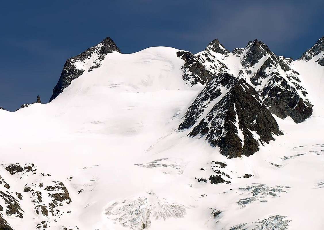
10) - go up to the Torre di Sant'Orso (3.610/8m) and finish in the South (see picture just below). As you can see, there is therefore no shortage of opportunities to climb the two Towers of Sant'Andrea starting from Valnontey and ignoring the possibility of ascent (East "Crestone" of august 1891, july 1934 and NE Wall of august 1911) from the Valeille side, as it presents routes that are more dangerous than difficult (see picture more in below). All that remains is the choice and ... good will.
Insieme al Gran San Pietro ed alla Torre di Sant'Orso, ancora più a Settentrione e sovrastante il Colle Coupé de Money (3.383/93 m) con il suo caratteristico Dito degli Apostoli (3.434/9 m), che svetta sia sopra il Glacier Coupé de Money e la Valnontey (ad Ovest) che sul piccolo anfiteatro morenico denominato "Crou du Grand Saint Pierre" e la Valeille (ad Oriente), formano la cosiddetta Catena dei tre Apostoli. Poi la cresta spartiacque si rialza con le due Punte Patrì (Meridionale 3.581 m, Settentrionale 3.561 m), la Punta Cissetta (3.419 m), le due Punte Valletta (Meridionale 3.352/6 m, Settentrionale 3.315/8 m), la Punta di Valmiana (3.244 m), la Punta Fenilia (3.053 m), la Testa di Montseuc (2.538 m) per terminare con il promontorio boschivo del Montseuc (2.333 m) sulla radura di Sylvenoire, appena sora gli abitati del Comune di Cogne e delle Frazioni di Champlong-Lillaz (quest'ultima famosissima per le splendide cascate, provenienti dal soprastante ad Oriente Vallone dell'Urtier). Tornando alle "nostre" due torri gemelle, c'é da osservare che le medesime siano sempre state ritenute complementari alla Torre del Gran San Pietro ed, al massimo, come degne di considerazione soltato con la prospettiva di effettuare la "Traversata degli Apostoli", ascensione poi divenuta "appetita" nonché desiderata soltanto col trascorrere del tempo. Tanto che rimasero "figlie di nessuno", ovvero innominate fino a quando il celebre alpinista inglese George Yeld (grande amatore della Valle di Cogne) ne propose il nome sull'"Alpine Journal" XVI, pag. 51 (così scrive la "Guida del Gran Paradiso Parco Nazionale", a pag. 432), per poi tracciare una bella via il 14 Agosto 1911, insieme alle due Guide della Valtornenche B. & A. Pession, sulla grande Parete NE che scende sopra la Valeille con un salto di oltre 500 metri (come da "Alpine Journal"X XV, pag. 734). Ma già B & V in "Guida delle Alpi Occidentali VOL. II. Graie e Pennine", pag. 77/78 così le cita quotando la "Sommità sud - 3.639 m, -" nonché la "Sommità nord - 3.650 m, -", così come appare anche nello schizzo o Tavola I, trable pagg. 72/73. Salita comunque già preceduta dalle "esplorazioni" dell'agosto 1890 e dei due percorsi del 1891, in uno dei quali troviamo impegnata la celebre cordata composta dal duo inglese Ellis Carr and Albert Frederick Mummery. Infine alcune recenti (10 Agosto per il Canalone ghiacciato della Parete O-SO e 30 Agosto per la Parete O-NO con salita mista, sempre del 1984) vie nel settore glaciale appena al di sopra del Glacier de Money, mentre la traversata delle tre torri (che poi sono quattro) é divenuta un classico per alpinisti esperti. Il Versante Sudorientale invece, per quanto ne sappiamo, non offre itinerari (un canalone nevoso che termina contro il castelletto roccioso tra le due sommità appare come invitante, ma é sicuramente molto pericoloso) a differenza della Torre del Gran San Pietro che ne presenta diversi, soprastanti sia il Glacier de Valeille (a NE) che il Ghiacciaio del Teleccio (a SE), nonché i sottostanti Colli del Teleccio (3.312 m) e di Ondezana (3.304 m), posti a cavallo tra gli omonimi valloni (vedi foto appena più sotto). Si consiglia quindi, volendo esclusivamente salire questa torre,
1) - di percorrere il couloir (che porta alla sella nevosa 3558 m) tra la Punta SO e la Torre del Gran San Pietro ed in seguito
2) - in traversata raggiungere la Punta NE; oppure
3/4) - di salire tramite una delle due vie dell'agosto 1984 (vedi sotto "First ascents") per poi
5) - scendere con lo stesso canalone. Ed ancora
6) -, salire alla Torre di Sant'Orso e
7) - raggiungere le due torri in traversata verso Meridione. Ed infine
8) - dal Glacier Coupé de Money salire il pendio glaciale tra la Cresta Paganini (3.440/7 m) e la Parete Ovest della Torre di Sant'Orso, arrivando al dosso nevoso (3.605 m) per poi attraversare "tagliando" verso SE, evitando la Sommità della medesima, per raggiungere il Colle Paganini (3.556 m), dal quale abbastanza facilmente alla Torre NE tramite la sua Cresta N-NO, donde tramite traversata a Meridione alla Punta SO. Buon ultimi
9) - salire alla Torre del Gran San Pietro (3.691/2 m) ed attraversare a Settentrione, oppure
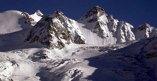
10) - salire alla Torre di Sant'Orso (3.610/8 m) e concludere a Meridione (vedi foto in alto). Come si vede, non mancano quindi le oppurtunità di salire le due Torri di Sant'Andrea partendo dalla Valnontey e tralasciando le possibilità di salita (Crestone Est dell'agosto 1891 e del luglio 1934 e Parete NE dell'agosto 1911) dal versante della Valeille, poiché presenta vie più pericolose che difficili (vedi foto sottostante). Non rimane che la scelta e ... la buona volontà.
First ascents
Punta Meridionale (Southwestern Summit):
First on the summit: G. Blanchetti and friend, (Aug 1881).
S and S-W Arête: W. Schultze and P. J. Pession, (Aug 16th, 1890).
W rocky Rib (incomplete route): Ellis Carr and Albert Frederick Mummery, (Aug 12th, 1891); from Money's Glacier with traverse to Colle di San Pietro and Gran San Pietro Tower.
W-NW Face (complete route): Osvaldo Cardellina and Marco Cossard, (Aug 30th, 1984); in ascent from Valnontey, Money's Bivouac, Coupé de Money and Money Glaciers, bypassing Paganini Crest; in descent, after traverse to Sant'Orso Tower, by N Crest and W-NW Face to Coupé de Money Col (3.383/93 m) and towards Glacier Coupé de Money and bivouac.
Punta Settentrionale (Northeastern Top):
E "Crestone": G. Stallard, L. Ormer, J. Ogi-Müller and A. Müller, (Aug 10th, 1891); in descent to Valeille's Glacier.
E "Crestone" (first complete in ascent): Piero Malvezzi with Courmayeur's Mountain Guide Ottone Bron, (Jul 27th, 1934) .
N-E Wall: George Yeld, B. Pession and A. Pession, (Aug 14th, 1911).
W-SW Face (Couloir): Osvaldo Cardellina and Marco Cossard, (Aug 10th, 1984); in ascent from Valnontey, Money's Bivouac, Coupé de Money and Money Glaciers, bypassing Paganini Crest; in descent, after traverse to Sant'Orso Tower, directly by W-NW Face to Glacier Coupé de Money and bivouac.
Getting There
From Torino, Milano, etc: Motorway A5. Exit at Aosta Ovest. Drive to the near Aymavilles. Follow the directions for Valle di Cogne.
From Switzerland: through the Grand Saint Bernard Tunnel or the namesake Pass. Drive to Aosta, then follow the direction for Courmayeur on SS.26. Just after Sarre, turn to the left, in the direction of Valle di Cogne.
From France: through Mont Blanc Tunnel or Petit St. Bernard Pass. It isn't necessary to take Motorway A5: you can drive on SS.26, in the direction of Aosta.Before arriving at the Village of Sarre, turn right following the sign for Valle di Cogne. After Aymavilles, the SR.47 crosses the Villages of Vieyes, Epinel and Cretaz and after about 25 Km arrives at Cogne (1.534m). From Cogne you can get the Village of Valnontey (1.666m).
BY PLANE:
Aeroporto "Corrado Gex" Saint Christophe (Aosta).
Route to the Money Bivouac
From Cogne (1.534m) along the road (public bus or by car) to Valnontey (1.666m - wide car parking). Along the Valnontey on its left side (E) and after the fine Pastures of Valmiana (1.728m) follow the path till the fork (0h'45) that, on the left, leads to the Money Houses. After about 2 hours walk you can see the Money and, little before getting there, keeping the left side, ascend along some morainic slopes and along the ridge of the lateral moraine (orographic right of the Coupè di Money Glacier). Along the moraine on small tracks, where it ends cross to the left a small valley of debris and broken rocks, up along a short but steep slope of rocks (anchors and chains) to get the well visible (yellow) Bivouac (2.872m - 1h'15 from Money) Little above the bivouac (anchors and chains) you can find the water coming out from Patrì Glacier.
Dall'abitato di Cogne (1.534 m) in bus o in auto sino a Valnontey (1.666 m) ove si parcheggia nell'ampio piazzale, risalire la Valnontey sul versante della destra orografica e superato l'ameno Alpeggio di Valmiana (1.728 m) si prosegue per il sentiero sino al bivio che sale verso sinistra per i Casolari del Money (0h'45). Dopo circa 2h'00 si notano i soprascritti casolari, posti a 2.325 m, poco prima di raggiungerli, sempre sulla sinistra, superare alcuni pendii morenici risalire il dorso della morena laterale (destra orografica del Ghiacciaio di Coupé di Money). Salire la morena sulla cresta su poco evidenti tracce di sentiero, alla fine della stessa attraversare verso sinistra un valloncello di sfasciumi e rocce rotte, superare il breve tratto di rocce abbastanza ripide (con l'ausilio di alcune catene fisse) che precedono di poco il bivacco posto a 2.872 m (1h'15 dai Casolari del Money). Il bivacco è di colore giallo. Acqua: proveniente da Ghiacciaio di Patrì si può trovare poco sopra il bivacco raggiungibile sempre con l'ausilio di catene fisse.
Route
From the bivouac, toward the right side (orographic) of Coupè di Money Glacier, cross it crosswise toward the base of the Cresta Paganini (3.440m), round it and follow along the Money Glacier (careful to the crevasses that may force to many bypassings) toward the icy slope between the Torre di S. Andrea and the Torre del Gran S. Pietro. Pass the bergschrund and start climbing the slide (~200m): the slant is between 45° and 50°. (warning!: the ending corniche could be very thin, stay some metres below it). Now to the left for some metres to get the ridge leading to the Southern Tower or SO Summit (3.644m), keeping the ridge down to the saddle and on again to the Northern or NE Top (3.651m). Time to go: 3h'00/4h'00 hours from the bivouac. Descend retracing your steps.
Salita alla Torre di S. Andrea: dirigersi verso la destra orografica del Ghiacciaio del Coupé di Money attraversarlo diagonalmente verso la base terminale della Cresta Paganini (3.440 m) aggirare la stessa cresta, da qui procedere decisamente sul Ghiacciaio del Money (prestare attenzione ai numerosi crepacci, che a volte costringono a noiosi aggiramenti) verso lo scivolo ghiacciato tra la Torre di S. Andrea e la Torre del Gran S. Pietro, con attenzione superare la crepaccia terminale e iniziare la salita dello scivolo (circa 200 m) con pendenze che variano dai 45° a 50° gradi circa. (Attenzione al cornicione finale che potrebbe essere molto sottile, restare di qualche metro al disotto dello stesso). Ora portarsi verso sinistra per alcuni metri e iniziare su cresta la salita alla Torre Meridionale oppure SO (3.644 m), sempre su cresta ridiscendere e salire alla Torre Settentrionale o NE (3.651 m). Ore 3h'30/4h'00 circa dal bivacco. Discesa dalla stessa via di salita.
Difficulties
This route can be considered PD/AD- (depending on mountain and ice conditions).
L'itinerario è classificato da PD a AD- (dipende dalle condizioni della montagna).
Equipment
High mountain gear: rope, iceaxe, crampons, helmet and some rock and ice pegs.
Da alta montagna, corda, piccozza, casco, ramponi, qualche chiodo da roccia e ghiaccio.
Red Tape
Within the borders of the P.N.G.P. (Parco Nazionale del Gran Paradiso), at the moment (summer 2004), dogs generally are not allowed, except on a couple of trails, and camping is forbidden (except for climbers from sunset till dawn). No fees are due.
Campings
Wild camping in the Parco Nazionale del Gran Paradiso is strictly forbidden!!! There are three camping sites very near to Valnontey Village. The most appropriate support point is the Money Bivouac.
Mountain Condition
Meteo: you can find all the needed informations at the official site of the Valle d'Aosta Region:
"Guida delle Alpi Occidentali" di Giovanni Bobba e Luigi Vaccarone C.A.I. Sezione di Torino Volume II (parte II), 25 Maggio 1896.
"Guida della Regione Autonoma Valle d'Aosta" di Mario Aldrovandi, Ed. S.P.E. di Carlo Fanton Torino, 1964.
"Rifugi e bivacchi in Valle d'Aosta" di Cosimo Zappelli aggiornata da Pietro Giglio. Musumeci Editore, Luglio 2002.
"Diari Alpinistici" di Osvaldo Cardellina e Indice Generale accompagnato da Schedario Relazioni Ascensioni 1964-2019 (inediti).
"Il Parco Nazionale del Gran Paradiso (Valli di Champorcher-Clavalitè-Saint Marcel-Laures-Cogne-Valsavarenche-Conca di Pila" di Giulio Berruto 3/volume 2°, IGC, Torino 1981, 2a Ed. 2000. (in Italian)
"A. Gegenfurtner, G. Klotz, F. Müller "Gran Paradiso", Ed. Bergverlag Rudolf Rother, Monaco 1980 (in tedesco).
"Gran Paradiso" di Pierandrea Mantovani e Renato Misischi, Ed. Rassegna Alpina, 1974.
"Gran Paradiso - Itinerari Alpinistici e sci Alpinistici" di Franco Brevini Ed. Musumeci, Giugno 1982.
"Guida dei Monti d'Italia-Gran Paradiso Parco Nazionale" E. Andreis, R. Chabod, M. C. Santis, Club Alpino Italiano/Touring Club Italiano, prima Ed. 1939; seconda Ed. 1963; terza Ed. 1980.
MAPS:
I.G.C. Istituto Geografico Centrale Torino "Il Parco Nazionale del Gran Paradiso" 1:50.000.
Kompass "Gran Paradiso Valle d'Aosta Sentieri e Rifugi" Carta Turistica 1:50.000.
Enrico Editore Ivrea-Aosta "Gruppo del Gran Paradiso" 1:50.000.
I.G.C. Istituto Geografico Centrale Torino "Gran Paradiso-La Grivola-Cogne" 1:25.000.
A.I.A.T. "Cogne Gran Paradiso Aymavilles - Walking Map" 1:25.000.
L'Escursionista "Valle di Cogne Carta dei Sentieri" (n° 10) 1:25.000.
L'Escursionista "Tour de la Vallée de Cogne Grand Paradis" Carta dei sentieri 1:25.000.
Parents refers to a larger category under which an object falls. For example, theAconcagua mountain page has the 'Aconcagua Group' and the 'Seven Summits' asparents and is a parent itself to many routes, photos, and Trip Reports.

 10622 Hits
 89.39% Score
 29 Votes