
|
|
Mountain/Rock |
|---|---|
|
|
37.85742°N / 107.623°W |
|
|
13552 ft / 4131 m |
|
|
Overview
North face of Tower Mountain

South face
NE Face, Tower Mtn far right
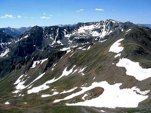
Tower Mountain is the highest of the 13ers that surround the town of Silverton in the San Juan Mountains of southwestern Colorado. It is visible from Silverton and Route 550 to the south. From far away it may not appear as the highest or the most dramatic looking peak in the area. A hike to the summit, however, reveals the true glory of this mountain.
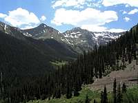
Tower Mountain can be climbed from Hematite Gulch, a steep drainage to the southeast. The hike takes you sequentially through groves of baby Aspen trees, Pine trees, spectacular fields of wild flower and the final scree and rock on the summit. Tiny Hematite Lake enhances the beauty of the area.
From the summit you will have fantastic views of Silverton, Route 550 and the surrounding mountains. The best view, however, may be that of the giant pyramid of Mt. Sneffels rising above the Red Mountains in front of it.
The summit is marked with a small pile of rocks. I was not able to find a registry nor did I see anyone while I was on this mountain.

Tower Mtn (R) & Silverton
Getting There & Route via Hematite Gulch

Tower Mtn in the center, south face, from Molas Pass
From Silverton drive 4 miles east on Route 110 (a well graded dirt road passable by any car) until you reach a bridge over the Animas River just before the ghost town of Howardsville. The starting point is on the left (northwest) side of the river at the mouth of the Hematite Gulch. Tower Mountain is not visible from the Starting Point.

Map
Trailhead Elevation: 9650 ft
One way distance per my GPS: 2.6 miles
Approximate Hiking Time (one way uphill): 3.5-4 hours
Map: US Geological Survey, Colorado (Howardsville grid).
Locate the two-track that goes up the slopes steeply. Do not confuse the two-track with a dirt road that follows the Animas River (San Juan County Rd 22A). Hike a very short distance up the two-track on the left (southeast) side of the Hematite Gulch until it dead ends into the creek. You will have to bushwhack your way a very short distance through baby Aspen trees on the left side of the creek until you reach a well-maintained trail. This trail is marked on the USGS map. I was not able to find its origin on Route 110. The trail makes an almost continuous series of switchbacks going up the left side of the steep Hematite Gulch through stands of small Aspen trees, Pine trees and mostly meadows until it reaches a relatively flat area above the timberline at 11900 ft.
This is the entrance into the Hematite Basin which is a small valley surrounded by the slopes of Tower Mountain and the nearby Macomber Peak (13222 ft). Once in the basin, Tower Mountain and Macomber Peak come into full view and the small Hematite Lake appears 100 ft below at the bottom of the basin. The trail crosses to the right side of the basin and heads up toward Tower Mountain across a short scree slope that soon leads to grassy slopes.
At around 12400 ft, the trail fades away but the route to the summit is obvious. You will have to hike up interesting scree slopes that seem to be covered with wild flowers. Farther up, the flowers disappear and the slopes become steep and slippery making the hike slow. The last 150 ft is a rocky block that can be climbed without difficulty.
 |  |  |  |  |
Weather
Click to see the forecast for Silverton, CO. Tower Mtn & Hematite Lake
 Tower Mtn from Macomber Peak
sanjuanmtnrocks - Nov 17, 2003 10:29 pm - Hasn't voted
Untitled CommentI've climbed Tower a couple of times from the Midway Mill above Eureka. You start at a higher elevation than you would from the bottom of Hematite Gulch, but the hike is a little bit longer. I've been up Hematite Gulch to the lake but not up the peak from there. I haven't been on Dome Mtn. (to the east of Tower) but it appears to be a good climb. Mark Mahlum, Durango