Introduction
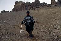
Alpinists are used to obstacles. Usually these are encountered on the actual peaks. When Nadine and I set off for the Mercedario area in Argentina, we didn't imagine the climbs of two 6000 meter peaks would be the easy part of the trip. The walk in was taxing. The way to Mercedario was dangerous and hard and the walk out was nothing but a life threating venture.
Two very intense weeks in the middle of Los Andes.The walk in and Ramada
The hot and dusty desert was left behind and we entered a narrow canyon. We were on our way towards
Cordillera De La Ramada, more well known as the Mercedario Massif. There was no set plan, but we were keen on seeing this area which soo many had told us was a nice place. We had been informed the normal walk-in route had been damaged by a huge flash flood and therefore we set out for Valle Colorado, a little river valley which ended close to
Mercedario’s gigantic south face.
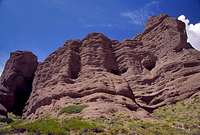
![Valle Colorado rock towers]() Colorful rocks on the walk in Colorful rocks on the walk in | ![Camp near the south face]() Camp just before BC Camp just before BC | |
At the beginning of the valley we met
Jarrett and his friend, who had climbed a new route on
Pico Polaco. They warned us about the difficulties of crossing Rio Colorado, where they almost had been swept away by the current a couple of times. We soon realized the warning was justified. If it had been a matter of life and death, I would’ve taken my chances crossing the small but violent river, but we choose to stay on one side of the river. The going got tough in places. Steep scree slopes, some nasty rock passages and at time quite a lot of exposure on high ridges. Our heavy backpacks full of provisions for 10-12 days didn’t make it easier. A commercial expedition, with the team members riding on mules crossed the river with relative ease, even if the animals sometimes had to push hard through the turbulent currents.
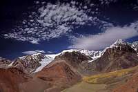
After three warm days in the beautiful valley we reached BC. We were stunned by the beauty of the place. Lots of high peaks were seen all around us and the 2000 meter high
south face of Mercedario was really impressive.
We joined forces with some Polish climbers and went for the 6384 meter high
Ramada. The walk towards the foot of the climb was amazing. Multicolored rocks with sharp colors. To the west we could see the glaciers of
La Mesa with its sub peak
Alma Negra. Small herds of Guanacos were seen and in front of us the north face of Ramada was looming. We had great conditions and quickly went up to 5400m and set camp. We tried out a route on the actual face, but the snow conditions were bad so we returned to base. The next day we summited the peak. The weather was great and we had excellent views of both of the two giants in the area: the nearby Mercedario and the more distant
Aconcagua.
It had been an easy and wonderful climb and we regretted we hadn't brought more food. There were so many nice peaks all around us.
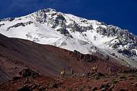
![Ramada and Guanacos]() Guanacos and Ramada's north face Guanacos and Ramada's north face | ![Mercedario seen from Ramada]() Mercedario from Ramada's summit Mercedario from Ramada's summit | ![A color dot]() A lone flower on Ramada's slopes A lone flower on Ramada's slopes |
New provisions and over Paso Ancho
We returned to BC and checked our food supplies. We had food for another couple of days and decided to climb Negro.
Anibal, a well known organizer of Mercedario expeditions was packing up for the season. He walked up to us and smiled.
-
Do you want some food? We’re going to throw it away anyway.
Gratefully we accepted the gift and asked him how difficult it would be to traverse over to the other side of Mercedario. He told us it was a quite steep and sometimes hard ascent and at best we could make it in a ten hour day from where we were. He warned us for rock falls and gave us directions. We further asked "how impossible" it would be to get out via Las Molles on the other side of the peak.
-
It’s a very bad and dangerous option. There was a Spanish guy who made it out, but he had to do some serious rock climbing.
Anibal further told us the Spaniard had really risked his life going out that way.
He concluded: I don’t recommend it, but it’s possible.
![Viento blanco cloud]() Looking at Mercedario from half way up Paso Ancho. Threating clouds are gathering Looking at Mercedario from half way up Paso Ancho. Threating clouds are gathering
| ![A bit on the way]() Arriving on a little plateau after the first steep part Arriving on a little plateau after the first steep part
| ![Steep]() Valle Colorado far below, seen from high on the way to Paso Ancho. Valle Colorado far below, seen from high on the way to Paso Ancho. |
Our backpacks were once again heavy, but we were happy to be able to stay in the area longer than expected. The first part of the climb towards Paso Ancho went fine. Far below we saw three of the Poles coming the same way as we did. The valley got steeper and harder. On our right we saw some very steep trails heading in the direction of the pass. It was obviously not the path we were going to take according to the directions we had gotten. I went further up the valley and checked the side valley we were supposed to use. It looked horrible. Steep, full of huge boulders and in one place I could see traces of a recent rock avalanche.
I went down to
Nadine and we had a little talk about what to do. The trails we had seen looked tough, but better than taking our chances in the rock-avalanche valley. We set for the former. It was very steep, but we got hope when we saw tracks of a mountaineering boot amongst all the hoof prints of guanacos. A human being had walked here before. Some easier sections were crossed and the guanaco trail continued. The tracks of the walker was not to be seen anymore, but we made quite good speed and walked on upwards. At about 4400m the trail got very steep again. I started to hesitate.
Very few guanacos had walked further than the point were we stood. On our right a scary drop into an abyss. In front of us the trail disappeared behind a large rock. I dropped my backpack and carefully went around the corner to have a look. Positively surprised I saw two things. It got even steeper, but this steep slope was covered with penitentes. We decided to walk on. It’s one thing to fall on steep gravel and another thing in a penitentes field. The up to two meter high ice pinnacles would stop any fall even if it got steeper than this. After some ardeous route finding, swearing and navigation we finally arrived at the top of the penitentes field and a little saddle. It looked better ahead and we could see the final pass ridge at 4700m.
We were thankful for the easy going and walked on fast. I rounded another corner and saw what was up ahead. A steep slide zone. Large boulders, some as large as trucks had slided or tumbled down the sloped ahead. It looked stabile though and we decided to continue. What we feared most was rain and to our horror a drizzle of cold precipitation started when we were half way up. I started to almost run up the slope, looking up at the threatening rocks high above me. I looked down and saw not only Nadine, but also the three Poles far down below. I was surprised. We had not seen them the whole day and I had been sure they had turned back. Small pebbles and some wet sand came down the slope, but the light rain had stopped. After a time which had felt like eternity we both finally reached the top of the slope and it felt like I could breath again. We waited a bit until we were sure the Poles had made past the slide zone and then continued. Paso Ancho was soon reached and a plateau-like valley opened up.
In front of us Wanda and to our left
Negro. It was getting dark and we soon found a camp spot on the alluvium fields. The Polish climbers arrived. They looked tired and had a scared looked on their faces.
- Which way did you go, Agnieszka asked.
- The guanacos trails, Nadine said.
- It was a good choice.
- No, it was very steep and sometimes scary.
- On our route, there had been a huge rock avalanche and we thought there were more to come. For three hours I thought we were going to die and then that last slide zone... Agnieszka shook her head.
After a short talk with the Poles we realized we had probably gone on a less risky route and we were all glad we had made it.
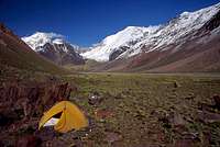
![Finally there]() Finally, on safe, flat ground on 4700m Finally, on safe, flat ground on 4700m | ![Negro plateau camp]() Our tent and Negro Our tent and Negro
|
Summiting Mercedario and Trabante II
The next day was warm and yesterday’s walk was almost forgotten. After only an hour we met the Polish climbers. They were on their way back.
- What’s up? Why are you turning back?
Silence. They looked at each other. Something was wrong.
- Hmmm. We don’t think we have enough time to climb Mercedario.
They had had a lot of discussions within the group and the conclusion was they were going back again. We took farewell and wished each other good luck. I felt sad we had lost our company, but there was nothing I could do about it.
Far below we saw some green meadows and...a road, which went all the way up on the morraines of the Caballito glacier. After a very steep, but easy scree descent we arrived on the mysterious road. It was in bad disrepair and we decided to camp right on it as a rain storm was arriving fast.
The following day we traversed some ridges and arrived on a trail which we guessed had to be the normal walk in to the higher reaches of Mercedario. At 4850m we decided to camp.
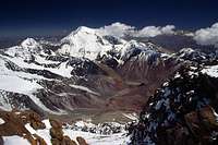
![Down]() Down a steep slope to the old mining road Down a steep slope to the old mining road | ![The steep walk down]() The scree hill we went down The scree hill we went down | ![Summit of Mercedario]() Nadine on Mercedario's summit Nadine on Mercedario's summit |
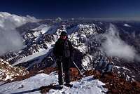
During our time in Argentina we hadn’t had any really long days and we decided to try for the summit from where we were. The normal (inca) Route looked a bit boring, so we felt; why not try out the glacier, then go straight for the summit from there?
We did and after about 7 hours since leaving the tent I was on the summit of the South American continent’s 7’th highest peak. Nadine was some way down and I wanted to have a look on the southern side of the peak. I slipped on some blue ice hidden under a thin layer of snow and took a fall of some meters. My camera's wide angle lens got badly messed up.
Nadine arrived and we enjoyed the views from the summit. Ramada looked huge and impressive, but what caught our interest was storm clouds gathering on the Chilean side of the border. We rushed down and arrived at our tent just after dark and ate a lot of food. We started to think a bit about what to do next. We still had provisions for about six days and I wanted to climb some more before leaving. What else was around?
Little Trabante II was summited quickly the following day and we continued our discussion about what to do next. We were not at all keen on crossing Paso Ancho again. The steep slopes had been bad enough going up and we were sure it could be even more dangerous going down. The issue about the slide zones, especially in combination with rain made us think more and more about trying to walk out via Las Molles. What opposed that idea was Anibal’s info and a story we had heard second hand. A team of climbers had been trapped after the flash flood and had been forced to stay for a long period before they made it out. We knew no details and we felt stupid we hadn’t asked Anibal if he knew something about. We finally decided we should try Las Molles, because "it couldn’t be worse or more dangerous than Paso Ancho".Destruction and the feeling of being trapped
Everything went fine down to the old mining road. We spent a night outside a refugio close to Laguna Blanca. We dropped quickly in altitude after the lagoon and it got warmer by the hour. The valley got steep and the little river wilder. We arrived at a slide zone. Not a bad one, but the gravel was very unstable. After and hour we had cut a path through with our ice axes and smiled. It was not as bad as expected. Two more similar obstacles followed and we more and more sure we would make it out without any problems.
![Huge fields of penitentes]() Down the penitentes field Down the penitentes field | ![Green valley]() Looking back at Mercedario Looking back at Mercedario | ![Clear water]() Spring from under ground Spring from under ground |
We heard a monstrous roar and soon realized the sound originated from a huge river – Rio Blanca. We arrived at a road which was in good shape and continued walking downhill. I noticed there were no fresh tracks on it.
A fence.
Two barrels. Signs of civilization. Trees.
A car!
A good-looking 4x4 was parked high up on a little hill. The sight of it gave me the creeps. I wasn’t sure why.
I stopped dead.
In front of us, on a flat, wide space a plastic orange chain formed a huge "H".
I was sure I had seen that one on a photo somewhere. It was usually the sign for a heli-pad. We walked on a bit and then I realized where I had seen the huge orange H before. It had been in an online article about the Las Molles flash flood. I got angry at myself I hadn’t paid more attention to the information when I had read it.
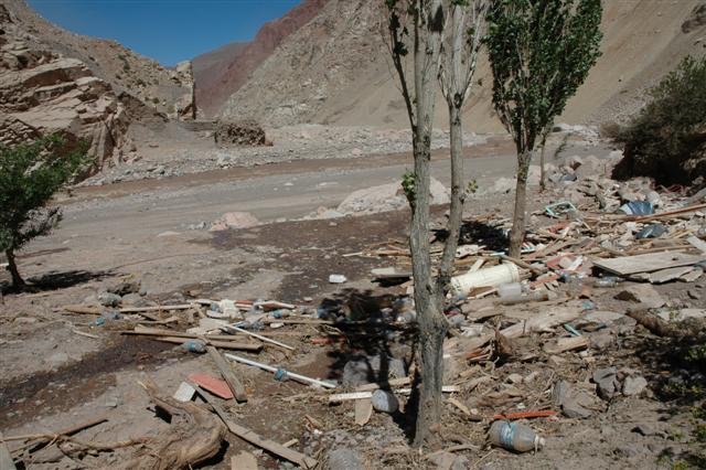
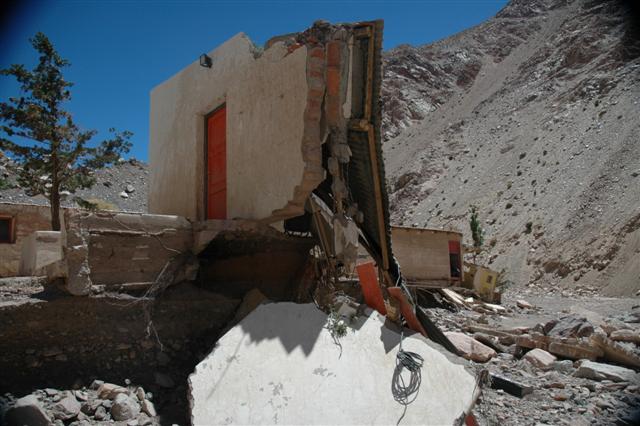
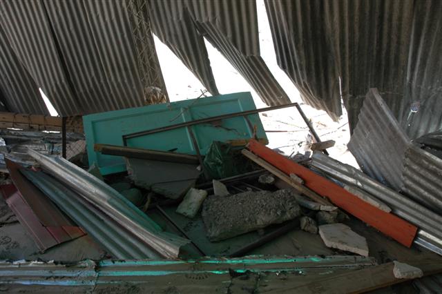
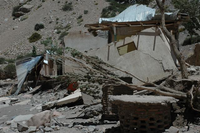
After walking down a little hill we saw buildings, or more correctly; ruins. Some had been cut in half, some were not much left of.
Lots of twisted metal.
Garbage.
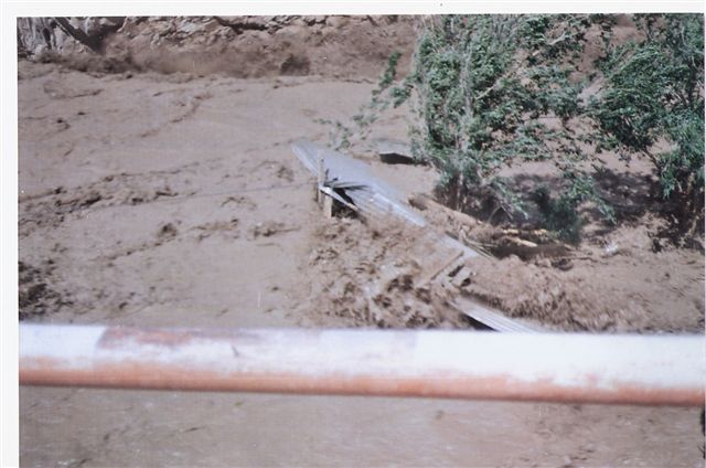
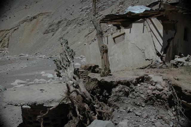
Corrugated sheets of metal which once had been roofs lay scattered all over the place. We had arrived in the mining camp of Las Molles and there was nothing left of it. The little settlement had been completely destroyed by the flashflood. The river was at 5-6 meters lower down now and it was hard to imagine it had been as much as probaly 15 m higher at the peak of the flooding. It must have been a wall of water sweeping away everything in its way. Nadine looked depressed and sat down in the shade under one of the few trees which were left.
The cause of the destruction
The remains of Las Molles mining camp
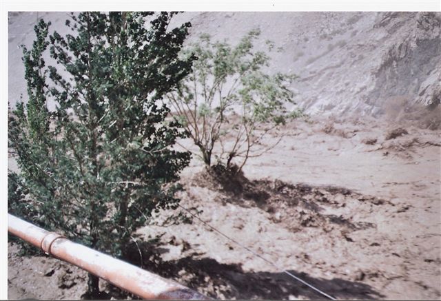
I looked down valley. A high slope full of boulders, sand and scree was on our side of the river. On the bottom Rio Blanca flowed and its surface bounced up and down in wild, chaotic bursts. Clouds of sand left the slope every now and then, indicating that there were things coming down almost constantly.
We had no clue what to do.
I was dead set on not going back over Paso Ancho and I was grasping for straws. Frantically I was looking around for material to build some sort of floating device or raft.
Some barrels around. Some bailing wire. Hmmm.
One look on Nadine’s face told me the whole story. She probably saw what I was thinking about and I gave up the idea. There was no way I could talk her into that one. I went down to the sliding zone.
It looked awful.
Large boulders, the size of small cottages blocked the way for most stuff that could come down the slope. Unless they were of the same size as the ones that had already crushed down. Nadine slowly walked towards me. She had a look of defeat on her face, but realized it would be a hard match to talk me out of the idea of trying to get past the slide zone.
- Go as fast as you find safe while you count to three. Stop at three and look up. Continue like that. If I call out, run for your life. If you see something coming down, shout as loud as you can.
I knew it was not the best of plans, but it was the best I could think of at the moment.
I ran.
Stopped.
Ran.
Nothing came down. I checked Nadine. She was not far behind, doing the same thing as I did. I was about to fall into the river. I crushed hard on a boulder. I looked up. It was ok. I ran again.
Nadine screamed.
I didn’t look up, but dashed as fast as I dared, jumping like a madman from boulder to boulder. I reached the other side. I looked back. A huge cloud of dust was coming down the slope about ten meters behind Nadine, who was almost safe by now.
She made it.
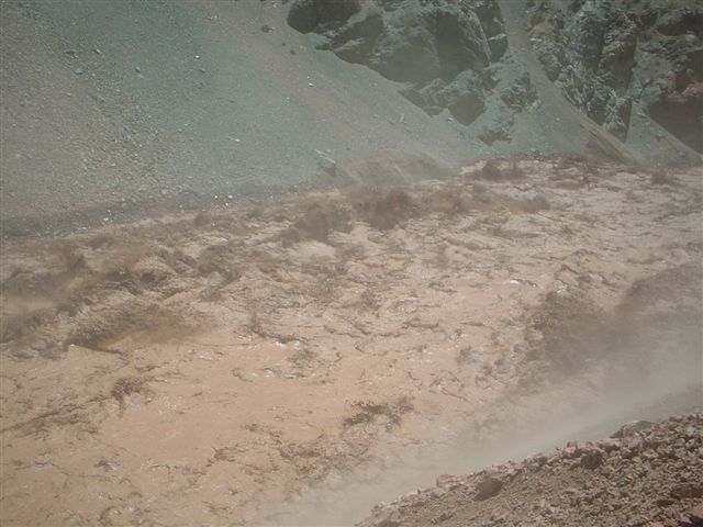
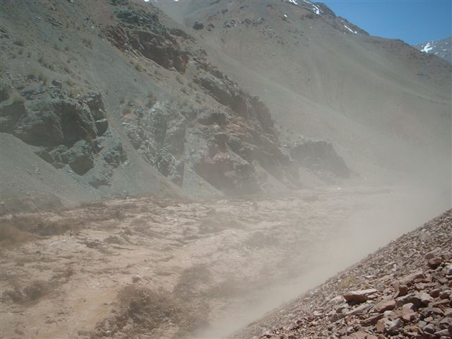
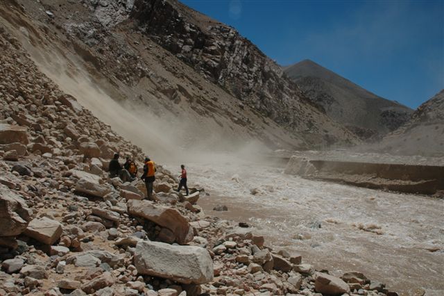
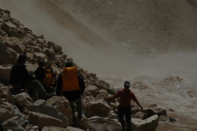
The slide zone
The photos below show the team which were stuck in the area in November. The conditions when Nadine and I passed where about the same as shown on Steve Shriver's photos. The first photo from before the crossing and the following two after the slide zone.
Eager to get away from the slide zone we walked on. A km further down the river made a sharp bend to the left. The river bed we walked on disappeared and a high vertical wall replaced it. There was no way to get past.
I swore and walked on. There just had to be a way. I saw a part of the road about 15m up. It was cut at the steep section, but I climbed up to it anyway. The little part of road which was left was not longer than 400-500m and I couldn’t believe my eyes when I saw a car on it. I walked up to it. I was not sure what I expected to find in it, but opened the door anyway. Two ID-cards lay on the driver’s seat. They informed me the two persons who had been in the car was mine workers. Fishing gear in the back seat.
As I have been confronted by flashfloods before I could somehow imagine what those two poor souls had felt when they had seen the wall of water coming down the valley. An over 15 m high chaotic, messenger of instant death, sweeping everything in its way to oblivion. I cold hand seemed to grasp my inner sanctum and I decided no to think more about it.
![The stranded car]() The car
The car
I walked to the end of the road. Another bad slide zone. We could possibly traverse it, but I would be extremely dangerous. The drop to the riverbed was about 20 meters. On the other side the sheer rock wall awaited us and from what I could judge it was at least 150 m of difficult climbing and a fall into the rapids of the river would be fatal. I started to think about leaving all my gear behind and make a try. I was awaken out my insane thoughts when Nadine arrived.
- What to do? She answered herself half a second later by saying, she didn’t want to go all the way back. I agreed, but what the hell to do instead.
- Those fishermen who left the car made it out somehow.
- Maybe they were rescued by a helicopter.
- Possibly. We can’t be sure of that. There must be a way. There just must be.
Desperation started to arrive.Pathfinders
We walked back to the car and realized there was a little narrow valley heading into the mountains behind it. It started to get late. I volonteered to check out the valley if Nadine set up camp. I jogged up a the valley and to my surprise I found some mule dung.
Hoofprints. Not many, but enough to give me a little bit of hope. I almost ran up the faint path for an hour and ended up in a huge amphitheatre. High ridges all around me. The path disappeared and the only signs of life I could see was guanaco trails leading higher up in the valley, which seemed to end with an unpassable cliff. On the left side of it there was a slope. A steep one, but maybe it was possible to climb it to the ridge.
I somehow got overwhelmed by some sort of realization. I started to debate with myself. We had made it through a lot of dangers and at one point you just shouldn’t challenge fate anymore. The only reasonable thing would be to go back. At least we knew what we had in wait for us. On the other hand, would we have the same luck with clear skies and no rain? Some of the areas we had walked through would be death traps if it started to rain or snow. What was up ahead? Was it plain stupid to continue even further into the unknown? I couldn’t decide what to do and what to say to Nadine? I slowly walked down towards the car again. My mood was very low when I arrived, but was met by a Nadine, who looked very excited.
- I saw a car! Look over there! That line you see is the road and I saw a bloody car there. It was going downvalley. That must mean from that point you can reach civilization. It’s so close. This is the last barrier. We have to make it over somehow.
- I’m not sure about the valley. It looked kind of doable, but...
- Let’s go first thing in the morning. If it’s impossible we go back, but we can’t stop here. It’s so close.
I had my doubts, but agreed.
Early next morning we went up the valley. We passed the point where I had stopped last evening and it started to look better. There was a small passage beside the rock wall and the valley seemed to continue. For hours we walked in rocky terrain and the heat started to make me thirsty. I sat down for a sip of water. I saw something green under a rock. I walked over and pulled out an empty package of Gatorade. It was from the States, not made in Argentina. I took it as a very good indication. There had been a westerner here. Both of us suddenly got a lot of hope back and we giggled about how happy you could get to find a piece of garbage.
The valley ended abruptly. More steep slopes. I went ahead for some reconnaissance. I reached a ridge. Huge drops into the valley we had walked in. My heart sank once again. There seemed to be a path on a slope on the other side of a small valley. I went there and realized it was a well travelled guanaco trail. Hope returned with might. I was NOT going back now. Screw sense. This trail had to lead somewhere.
I jogged on on a lofty ridge and almost ran into a guanaco which hadn’t heard me coming. It ran away a hundred meters and stared angrily at me. It went on. I followed. The guanaco stopped and let out a shrill sound. It countinued like this for half an hour until the path all of a sudden dropped down a mountain side. It was so steep the guanacos had choosen to make switchbacks. Far down below a wide valley beckoned. This was it – the way out!
![Broken road]() The cut road The cut road | ![Ansilta range]() Ansilta Range Ansilta Range | ![Hope]() Hope of finding a way out Hope of finding a way out |
I went back to Nadine and told her the good news. After this moment everything happened very fast. Three hours later we were on the road, the uncut, "real" road which would take us out of the area. Half an hour later a truck arrived. The road construction workers first looked at us as they had seen two ghosts, but then smiled and gave us a ride down to the end of the valley. The next day we once again got lucky and got another hitch all the way to the main road at Barreal. Just before we were about to leave the car, the driver asked us if we wanted to join them to Uspallata, a little travel hub 150km away. The town is famous for its great restaurants and two hours later we sat in our favorite pizzeria eating as much as we could.
It felt like eternity since we had left the fishermen's car on the cut road, but it was actually not more than 36 hours.Cloud gallery
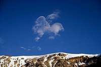
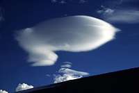
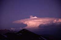
I have always liked clouds. During the period I was in Cordillera de La Ramada, there was a lot of nice ones, but at the time I couldn't enjoy the sight of them much. Every new formation I looked at as a pontential bringer of rain and land slides and in the extention more trouble for us. Anyway, here are some of them.
![Cloud dance]() A first small sign A first small sign | ![Spotted sky]() An hour later An hour later | ![Zeppelin?]() Strange shaped lenticular Strange shaped lenticular |
![Night clouds]() Pink night cloud Pink night cloud | ![Cloud]() Golden night cloud Golden night cloud | ![Golden night clouds]() Night cloud Night cloud |
The flash flood of Las Molles & links
A dam created by a land slide collapsed and caused the huge and devastating flash flood.
The first one to see what was happening was a mulatero who was almost right underneath the lagoon when the dam broke. Most of his mulas perished, but the man somehow managed to ride up on a slope and escape death with a couple of meters.
When the wall of water reached Las Molles it fortunately had diminished a little bit, but still it swept away most of the mining camp. It was reported to be about 15m/50feet at some places and about 10m/30feet at Las Molles.
By a miracle no one was killed.
In late February 2006 road construction was in full swing, but the date for making the road passable again had been set further and further into the future. No one really knows how long it will take until the road is mended and drivable again.
You can find an article about the climbers which got trapped above Las Molles here.
The rescue: A first-person account - Waiting for something, anything.
No way home - Photo story
A press message from an organizer to clients. Found on the www.
"We hope you are doing fine. Here we are a bit complicated since one week ago a huge flooding destroyed all the trail going to Mercedario´s Normal Route trailhead (El Molle). There was people evacuated by helicopter (more than 60) and there are some climbers now that need to be evacuated from El Molle. The flooding was apparently produced by a big lagoon collapsing in the upper Andeans and generating a big water wave of more than 20 meters high!...destroying several huts and all the mining path we normally use to approach Mercedario by the north side. Even when this situation is interfering with our ongoing expeditions we are pretty confident that the trail will be repaired in less than a month time (at least this is what we learn from the mining companies) so it should all be ok for the time when your expedition takes place. If is not, we will let you know what arrangements in your itinerary are needed. We will keep you informed about this situation."Credit
My camera got damaged from the short fall on Mercedario and for some reason it worked when it wanted to during the walk out.
Steve Shriver from Eco Lips, who in November 2005 was one of the trapped climbers was kind to let me use some of his photos for this article.
All photos showing the flash flood and the team's struggle to get out of the area is his property.


Comments
Post a Comment