
-
 24604 Hits
-
 84.7% Score
-
 19 Votes
|
|
Mountain/Rock |
|---|---|
|
|
40.65560°N / 111.756°W |
|
|
9410 ft / 2868 m |
|
|
Overview
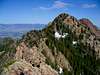
Triangle Peak is the unofficial local name given to the first major peak to the east of the very popular Mount Olympus. The peak's name arises from the distinctive triangular shaped north face of the peak as viewed from the Salt Lake valley. Newer USGS maps identify the mountain as "Hobbs Peak", but the more commonly known local name of "Triangle Peak" will be used on this page.Triangle Peak is somewhat of an oddity, as there are numerous higher points on the ridge extending eastward from the summit. When viewed from certain perspectives it becomes apparent that Triangle Peak is merely a prominent point on a ridge that generally becomes higher in elevation moving further to the east. However, none of these higher summits present as striking an appearance when viewed from the east side of Salt Lake Valley. Since these unnamed peaks are obscure and very infrequently climbed, they have been included on the Wildcat Ridge route page, rather than creating a seperate mountain page for each of the peaks.
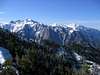
The peak lies on the long and very rugged Wildcat Ridge, which extends east from the summit of Mount Olympus, and continues on to Mount Raymond. Triangle Peak and Wildcat Ridge are located within the Mount Olympus Wilderness Area of the Wasatch-Cache National Forest.
Although it lies less than one mile to the east of Mount Olympus, which may often be climbed by several dozen or more hikers on fair-weather weekends, Triangle Peak is deceptively difficult to reach and very infrequently climbed. The peak may rival the significantly higher North Thunder Mountain as the most difficult and least climbed of the Wasatch Front peaks.
USGS Quads:
 |  |  |  |  |
Getting There
The most practical and, ahem, "easiest" ascent of Triangle Peak is by way of Mount Olympus and the Wildcat Ridge route. This requires first making an ascent to the south summit of Mount Olympus, typically by way of the Mount Olympus trail. Refer to these pages for complete details.The following information on additional route possibilities has been provided by Summitpost member Dmitry Pruss:
I've been across the saddle immediately to the West of the Triangle, and on the ridge immediately South. Although I haven't reached the top either time, they are all logical routes.
The West saddle is accessible from the Heughes Canyon trail (and you may opt to ascend Southwest slopes instead, going directly to the Triangle).
The beautiful cliffy North saddle is accessible along the ridge separating Norths Fork from Thomas Fork of Neffs Canyon (first gaining the ridge by the climbers' spur trail to the gray cliffs). It's rather technical from the North saddle up the triangle face, but easy traversing underneath the face to the West and ascending West saddle.
And South ridge is an easy off-trail hike from Mule Hollow mine.
You can probably access the Triangle from the NW by taking Neffs Cave trail, but I haven't been there beyond the cave.
 |  |  |  |
Red Tape
Triangle Peak and much of the surrounding area is located in the Mount Olympus Wilderness Area, where the following acts are prohibited:Much of this area is also located within the Salt Lake County watershed, which entails special restrictions.
When To Climb
Late spring through early summer are ideal. The moderate elevation and direct sun would make mid-summer climbs very hot undertakings, and would require carrying significant amounts of water.For those wishing to attempt the climb with an experienced group, the Wasatch Mountain Club typically schedules the hike on the weekend falling nearest the summer solstice, the logic being to maximize the available amount of daylight for this unusually long and demanding hike.
Winter attempts will require significantly greater effort, and will be complicated by potential avalanche danger and the short daylight hours.