
-
 9917 Hits
-
 79.78% Score
-
 11 Votes
|
|
Mountain/Rock |
|---|---|
|
|
32.21570°N / 111.0958°W |
|
|
Pima |
|
|
Hiking |
|
|
Spring, Fall, Winter |
|
|
3990 ft / 1216 m |
|
|
Overview
 "Bren's Better" from the northwest
Note the Tucson Mountains Chaos geography
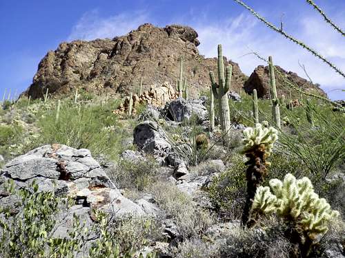
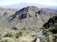
Known by some locals simply as “Brens,” UN 3,990 or “Bren’s Better,” is an interesting desert peak. The mountain is a primo example of what geologists call Tucson Mountain Chaos, a confusing jumble of rock types. My hiking partner, trained in geology, recognized an odd variety of rocks in a seemingly senseless pattern, and some follow-up research confirmed we were looking at the following: limestone, volcanic tuff, rhyolite, granite and schist. On the northwestern slope of “Bren’s Better,” a incongruent gray chunk of limestone seems to ooze mysteriously from the red rock making up most of the mountain. “Bren’s Better” and neighboring Tucson Mountains are some serious rock-nerd eye candy.
Leaving the maze of developed hiking trails in the Tucson Mountain Park for the summit of “Bren’s Better” is a delightful treat. Departing the broad highway of the Yetman Trail, the hiker can closely (but not too closely!) examine the tough desert plants that call this area home: Palo Verde, Cholla, Barrel Cactus, the might Saguaro and more. Sounds from the city of Tucson seem to melt away as you go deeper into the desert and higher on the mountain. Dynamite views from the summit include neighboring Tucson Mountain peaks, the Santa Catalinas and downtown Tucson.
Arizona Rank: 4208th highest peak in Arizona
Prominence: 808 feet
USGS Quad: Cat Mountain
Trails Illustrated Map: #237 Saguaro National Park
Rank and Prominence Source: Lists of John
| Note: There are three highpoint candidates along the summit ridge of “Bren’s Better”: While the northern point seems higher, the summit register and cairn are planted on the southern point. My GPS seemed happiest someplace in between…be certain to visit all three highpoints during your visit! |
Getting There

 |  |  |
| Tucson Mountain Park resides 13 miles to the west of Tucson, Arizona in Pima County. The park can be reached via Gates Pass Road or by taking Ajo Road to Kinney Way. |
Red Tape
 "Bren's Better" from Golden Gate Mountain
 Descending "Bren's Better
| There is no entry fee for Tucson Mountain Park. The park is open daily 7:00 AM to 10:00 PM. Click here for full rules governing use of Pima County Parks. |
Camping & Lodging
 Cholla and a northern outcrop
The only nearby campground is the 130-site Gilbert Ray Campground, located in Tucson Mountain Park. The proximity of "Bren's Better" to the Tucson Metro area means lodging options are virtually unlimited. Visit the Trip Advisor site covering Tucson, AZ, for more information about area accommodations. |
Weather & Seasons
| *Most hikes in the Tucson Mountains, thanks to their low elevation, would be most comfortable in the fall, winter or spring. *March and April are primo wildflower viewing months. *Summer temperatures in this part of the Sonoran desert can be worse than uncomfortable; they can be downright dangerous! *According to the United States National Weather Service, the record high temperature for Tucson, Arizona, set on 26th June 1990, was 117 degrees Farenheit / 47 degrees Celsius. |
