
-
 14773 Hits
-
 88.95% Score
-
 28 Votes
|
|
Mountain/Rock |
|---|---|
|
|
46.27911°N / 13.45276°E |
|
|
Hiking, Skiing |
|
|
Spring, Summer, Fall, Winter |
|
|
5489 ft / 1673 m |
|
|
Initial remark: In Slovenian language č, š and ž are pronounced like ch, sh, and zh. The highest summit of this ridge, for example, is written Kobariški Stol. Regarding its name - locals name the mountain only Stol (=Chair). But as we have in Slovenia also its higher counterpartner in Karavanke, in the last years our mountain is by the nearby town Kobarid more and more frequently referred as Kobariški Stol.
Overview
Intro
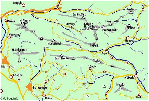
For the southern part of Julian Alps, where they blend into Prealps, long, but still narrow and steep ridges are characteristic. The longest one, the South Bohinj Range runs some 40 km. The Kobariški Stol - Gran Monte range runs in the East-West direction 'only' some 34 km. The range is rising south of Kanin/Canin group. More towards the SE there are also similar Matajur, 1641 m, and Kolovrat, 1242 m, ranges. The eastern part of the ridge is on the Slovenian territory, the western part on the Italian territory. Today, the border is no more an obstacle to cross the whole ridge in any direction. Because of a different naming on both sides - on the east the range is called Stol ridge, on the west it is called Gran Monte - I am also keeping both names in the main title.
Borders of the area
The eastern border of Stol / Gran Monte range is the valley of river Soča. Just at Kobarid town the long ridge comes down to its river bank. Towards the west the range stretches to the valley of river Torre / Ter. That's why it looks that here we have two distinct mountains, but between the two the range does not lower at all. The southern slopes of the range are falling down into Breginj valley (in Slovenia), where the river Nadiža / Natissone flows. In the Italian part, below Gran Monte there are nice terraces with villages, around the Cornappo creek some side hills of the group are formed. The northern border of the range is on the east first formed by Soča river (to Žaga village), then by its tributary Učja / Uccea. Between the valleys of Učja / Uccea and Torre/Ter there's an important saddle, named Tam na meji / Tannamea, dividing Stol - Gran Monte range from the similar, but sharper Muzci / Musi range on the NW. Over that saddle a good asphalt road goes from Soca valley to Torre / Ter valley.
Elevations
Eastern part. From Kobarid on the east, the range is rising first steeply, then more and more moderately. While the Napoleon bridge over Soča is on the altitude of only 216 m, the first bump in the range, Baba, is already 767 m. From there, the range goes less steep over Starijski vrh, 1136 m, Point 1281 m, Vršanja glava, 1353 m, Mali vrh, 1404 m, to the highest point of Stol, 1673 m. More towards the west the ridge gets narrow. Till the border there are the summits: Puntarčič, 1562 m, Ribežni, 1516 m, Mali Musc (also: Muzec), 1612 m, Veliki Musc (Muzec), 1638 m, Nad Ohojami, 1576 m and Gnjilica, 1463 m.
Western part. Going across the Slovenian-Italian border, we have first the summit of Punta di Montemaggiore / Breški Jalovec, 1613 m, then Punta Lausciovizza / Lanževica, 1620 m, then the highest elevation on Gran Monte Brinica / Briniza comes, 1636 m, finally Monte Testa Grande, 1556 m and M. Contesa / Mali vrh, 1466 m. All these summits are connected by a marked path, and reachable also by many marked paths from valleys on the north and south. For the characteristics of the ridge landscape, please see the 'Crossing Gran Monte - Stol Ridge' route description!

On the grassy ridge
Characteristics
As expected, the southern slopes of the range are bare, grassy, also on many places intermitted with rocks. The northern slopes are up to the summits covered with dense woods. As these mountains receive the first waves of wet clouds from the west, they are well known by the highest amounts of precipitations in Julian Alps. That's why despite relatively low altitudes also the snow heights in winter are considerable. Even if the altitudes are low and the summits are not hard to reach, a hiker must cosider some specific attributes of the area. First, the area is generally still very remote. On the mountains you will meet generally only few people, some places on the northern side are still very wild and covered with a dense, almost impassable vegetation. So, better stay on paths. The second characteristic is still a considerable steepness of the southern slopes. On those grasses you can in wet conditions also easilly get into serious troubles.
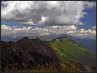
Summit Views
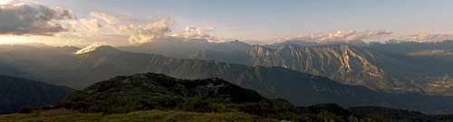
Due to the road, the eastern part with Stol is easilly accessed, ascents on the other summits are also not hard but a bit longer. The mountains in the Stol - Gran Monte range are known as among the most beautiful panoramic points in the southern Julian Alps.
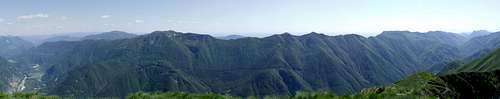
Towards the west and the south forehills are lowering down to the Po river plane. The neighbouring Muzci / Musi range on the NW impresses with its sharpness. On the east, Krn massif is rising, nearby we beautifully see its westernmost part, the Polovnik ridge. Immediately towards the north, the Kanin / Canin massif is rising, its characteristic bare, rocky, sun burn slopes are very clearly seen. And far behind, along the Soca valley all giants of Julian Alps can be seen. And deep below are the remore villages on the southern side of the range.
 Stol W view |
 Kanin from Musci |
 Montemaggiore view |
Getting There
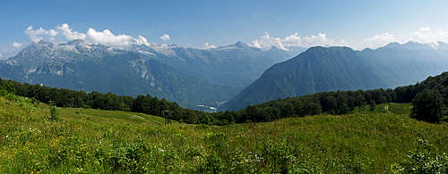
Kanin group and Julian Alps fore-hills
For general overview, see the Julian Prealps page and the Julian Alps page. You can start the tours on the Stol - Gran Monte range in the neighbouring valleys. But to shorten the summit ascent to the highest point, you can also use the mountain road, which ascends the ridge below Mali vrh from the north, from the Slovenian side of the border in Učja/Uccea valley. Near the ex customs office you deter southwards, cross the N slopes of Stol and reach Na Verilih / Božca alpine meadow on the main ridge.

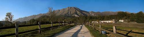
Stol from Breginj
This point on the main ridge can be also reached over the southern slopes. From Breginj valley (Sedlo village, 495 m) a narrow road ascends in many turns over the steep slopes to the ridge. It can not be done by car, but is quite often done by mountain bikes (900 m). From the parking place on the main ridge to the highest point you have only 45 minutes more to go (300 m). Other suitable points to start tours are on the Italian side. On the southern side these are villages Monteaperta, Cornappo and Montemaggiore, which can be reached by good roads from the south. On the northern side an important starting point is the saddle Tam na meji / Tannamea, 851 m, or the point 720 m just west of it.
Routes Overview
Because the summits are easilly accessible, below I am giving just a few ideas or recommendations. The tours can be combined on many ways, an also some other tours can be introduced - by paths, which are not marked.

Summer Routes - East
1. Na Verilih - Stol. From 1375 m (parking place on the main ridge) to the summit. 300 m of altitude, 45 min. Easy walk-up.
2. Stol from Breginj. 2.a. From the village of Breginj directly on top. 1150 m, 3-4 h, down by the same path.
2.b. From Breginj directly on Stol, down by the road or by the nearby marked path. If you'd have prepared bikes on top of the road, you coud ride down!
3. Stol from Učja / Uccea valley. If you don't follow the road all the time up to the main ridge, you can make a shortcut from below Hum (1109 m) towards the south and reach the summit ridge through Dol valley west of the highest point. Not marked. From the road some 1:15 h, from the asphalt road in Učja / Uccea 3 h.
4. Stol from Kobarid. The long all the times marked ascent goes just from the town (234 m) and will require some 4 h 30 min of walk-up to reach the summit.
5. Musci from Breginj.
5.a. From Breginj directly up on Mali Musc, then by the ridge to the bivouac, on Veliki Musc. 1200 m of ascent, 4 h. Down directly by the same path.
5.b. Breginj - Musci - Stol round tour. The same ascent as 5.a., but then by the ridge towards the east. From the bivouac to the summit of Stol you need some 2 h. If you wish, you can extend the round tour even more towards the east.
5.c. Breginj - Na Nizkem - Musci - (Stol) round tour. Na Nizkem is a saddle, just east of Gnjilica summit. The saddle can be reached by a path from Breginj in some 3 h 30 min, and then we go by the ridge towards the east as long as we wish. To the bivouac we have another 1 h 30 min, to Stol 2 h more and down in Breginj again some 2 h 30 min. So, already a day tour.
Summer Routes - Western Part

6. Montemaggiore / Breški Jalovec from Montemaggiore / Brezje village. A good marked path ascends from the village towards the north and reaches the summit from the eastern side. 800m, 2h 30min.
7. Montemaggiore / Breški Jalovec from Rio Bianco / Beli potok valley. The path No. 712 starts on the main road, goes over Starmaz / Strmac alpine meadow on the summit with the same name, and then further towards the south on top. Some 1000 m of altitude, 3 h 30 min. We can return by the ridge towards the west and by Ricovero Montemaggiore down on Tannamea / Tam na meji saddle.
8. Punta Lausciovizza / Lanževica from Tannamea / Tam na meji saddle. We can do a small round tour in any direction. The eastern variant goes first to the mountain hut, then on top, the western variant first reaches the main ridge, then we go east by it and by the hut down. 800 m of ascent, 2 h 30 min. We can also go by the ridge towards the west on Briniza / Brinica, but must then return by the ridge back.
9. Punta Lausciovizza / Lanževica from Cornappo. From the village we go towards the NE on the main ridge and either return by the same path or continue towards the east on Montemaggiore / Breški Jalovec, and from there down in Montemaggiore/Brezje village and by a marked path back in Cornappo. Ascent on the ridge 3 h, the whole round tour some 7h.


10. Monte Briniza/Brinica from Monteaperta. The path No. 711 uses a comfortable mulatiera (broad military path), which winds up to the big cross, standing on the main ridge on 1540 m. Then towards the W to the highest point. 3 h 30 min. In combination with path No. 710a (below #11) a nice round tour. (Description in Italian)
11. Monte Testa Grande from Monteaperta. Interesting, on some places very steep marked path (No. 710) reaches over the south grassy slopes the main ridge (3 h). In combination with path No. 711a (above #10) nice round tour - we continue from Monte Testa Grande over many sharp peaks towards the east on Briniza / Brinica (4 h from Monteaperta), further to the big cross and down. (Description in Italian)
12. From Torrente Mea on Briniza / Brinica. Over the Meadow Kripizza / Kripica by the valley of the creek with the same name on the main ridge and then over Monte Testa Grande on top. 3 h 30 min. Down by the same path or towards the east and down on Tannamea / Tam na meji saddle.
13. Crossing The Whole Range. Crossing the whole Stol - Gran Monte range is one of the most beautiful tours in Julian Prealps! The idea is to leave bicycles on one side, drive to the other side and do the whole range in two days, sleeping in the bivouac in the middle of it. If not the whole range, a very comfortable option is also to leave bicycles on the parking place on Na Verilih (1375 m, on the main ridge), drive with a car to Tannamea / Tam na meji saddle, do the crossing in two days and complete comfortably the tour with bikes. We did that tour in 2008 and was an extraordinary experience! So:
13.a. Varaint with two cars. Leave one car in Kobarid town, drive with the other one either in Monteaperta, or in Torrente Mea valley or on Tannamea / Tam na meji saddle. Ascend the first day on the ridge and cross it from Briniza/Brinica all the way to Musci bivouac. The second day do the rest of the range towards the east. Times: Ascent on the ridge 3-4 h, crossing Briniza/Brinica and to Montemaggiore / Breški Jalovec - 3 h, to bivouac - 2 h. From bivouac to Stol - 2 h, from Stol to Kobarid - 5 h.
13.b. Variant with bikes and one car. Drive on Na Verilih (Božca meadow) and leave bikes there. Drive with the car around on Tannamea / Tam na meji saddle or even down into Torrente Mea valley. Do first day the same tour as described above (#13.a.). For the second day now you have only 2 h on Stol, 1 more h to the bikes, and some 1 h 30 min of biking around to the car.
Mountain biking
1. From Breginj valley, Sedlo village, 495 m, by the narrow mountain road up to the main ridge - Na Verilih, 1375 m. Descent towards the north in Učja / Uccea valley and back aroud via Kobarid.
2. From Učja / Uccea valley by the mountain road to the main ridge - Na Verilih, 1375 m. There left and by the main ridge down towards Kobarid (cart-road). On Starijski vrh the cart road finishes. We continue by the path left down towards Hum and from there by a cart-road all the way down to Trnovo. Demanding bike!

Planina Bozica
Ski Tours
The summit slopes of Kobariski Stol are very nice for ski tours. Grassy, not too steep, approapriate also for hard winter time. You start the tour on the asphalt road in Učja / Uccea, ascend the summit in 3-4 hours and ski more or less directly down. The safest variant is around: from the summit by the main ridge to Na Verilih and by the road down. If you turn East of the summit northwards, you can cut through beech woods to Božca alpine meadow (you hit it by the hunters hut on 1270 m). The third option would be to ski down by the valley which starts west of the summit (Dol) and goes northwards. By this route you'd hit the mountain road on some 1200-1300 m.

Sušec creek
Canyoneering
Down the northern slopes of Kobariški Stol the Sušec creek flows. Its lower 300 meters of altitude are popular as a guided canyoneering tour. The start is near Srpenica village. By a steep path you ascend those 300 meters and then descend by the creek water bed. A few nice places and jumps into ponds. Also the lower part of Učja/Uccea creek are an interesting gorge, where the canyoneering is possible. And probably some other creeks too. On the Italian part, below Montemaggiore/Brezje, there is the Bončič creek, which has some waterfalls, reachable by a marked path. Also towards the south from the main ridge the Nadiža/Natissone river flows. Its valley is very nice for hiking.
Three Cultural Monuments

Above Kobarid you can visit three interesting items:
- Memorial place to soldiers, died in World War I - just above the town.
- Tonocev grad. An ancient settlement, used from neolythic on. It saw its best times in times of peoples' migrations - between 4th and 6th century a.d.
- The Kobarid Museum. Very well presented history of the World War I on this area.
When To Climb
Any time of the season.
 Early summer |
 Autumn |
 Ski-tour season |
Red Tape
There are no limitations.
 Soča river |
 Bouquet |
 Daffodils |
Huts and Bivouacs

Musci bivouac

Ricovero Monteaperta
The ascent on Stol can be normally done in one day. For traversing the whole ridge bivouacs, which stand on it, might be useful.
Hlek, 1225 m (on the eastern side of the ridge).
Bivak pod Musci, 1580 m. Between Mali and Veliki Musc (Muzec).
On Gran Monte, there's a hut on the altitude of 1468 m - Rif. A.N.A. Monteaperta. It is reachable from Monteaperto, 614 m, in 3 h or from Tannamea / Tam na meji saddle in less than 2 h.