|
|
Mountain/Rock |
|---|---|
|
|
36.30783°N / 50.99900°E |
|
|
Mountaineering |
|
|
Summer |
|
|
13337 ft / 4065 m |
|
|
Overview
Click for Introduction to Central Alborz Mountains.Click to see the Map of the Takhte Soleyman Massif.
NOTE: The 4065 m Alaneh Sar Peak should not be confused with the nearby 3940 m Alaneh Sarband Peak.
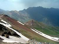
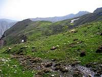
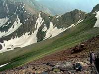
 View from the northwest, Alaneh Sar is the peak in the middle
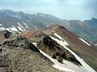
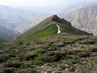
 View from the southeast
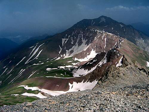
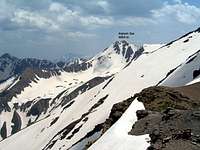 North Face
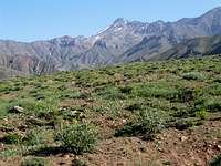 South Face
 Summit
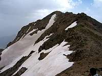 Summit
Alaneh Sar rises on the crest of the southeastern arm of the Takhte Soleyman Massif. To the northwest, Alaneh Sar is connected to the 4030 m Khers Char Peak (via Peak 3990 m). The southeastern ridgeline of Alaneh Sar gives rise to a number of rocky sub-peaks and eventually connects to the 3870 m Sebrar Peak.
The northeastern slopes of Alaneh Sar drop into a branch of the Chalus River valley. These slopes house large snow fields that usually survive into mid summer. The southern and western slopes of Alaneh Sar go down into two different branches of the Shah Rood (Taleghan) Valley.
The southeastern arm of the Takhte Soleyman Massif runs in a NW-SE direction and is roughly 15 Km long stretching from the 4256 m Lashgarak the Great Peak to the NW to beyond the 4198 m Zarrin Kooh Peak to the SE. It creates a barrier to the moisture laden air from the nearby Caspian Sea. While the branch of the Chalus River Valley to the north of the ridgeline is covered by Caspian Forests (up to an elevation of 2300 m), the branch of the Shah Rood River (Taleghan) Valley to the south is bare.
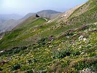
Alaneh Sar is a long way from any trailhead and reaching its summit and making it back to the trailhead will require more than one day. Although a worthy destination by itself, Alaneh Sar is usually climbed by those who like to traverse the southeastern arm of the Takhte Soleyman Massif. Several approaches to Alaneh Sar are possible. These include:
1) From the southeast via the village of Narian and the summits of Zarrin Kooh and Sebrar Peaks (see “Routes” below)
2) From the southwest via the Parachan Village
3) From the northwest via the Khers Char & Lashgarak the Great Peaks (see “Routes” below)
4) From the east via the village of Dalir in the branch of the Chalus River.
 Southeastern Face Southeastern Face |  West Face West Face |  False Summit False Summit | 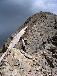 Summit Summit |
Routes:
a) From the summit of Khers Char Peak:
The starting point for this route is the summit of Khers Char Peak. Click here to see the page for the Khers Char Peak.
From the summit of Khers Char, head southeast and do some hand and foot descending until you reach an easy ridge-top that can be hiked. Continue southeast and hike to the top of Peak 3990 m. A little more hand and foot descending will take you down to a 3950 m saddle.
Continue southeast and follow the ridge-top up beyond a false summit until you reach Alaneh Sar.
Total distance from the summit of Khers Char is 3.20 Km.
b) From the summit of Sebrar Peak:
The starting point for this route is the summit of Sebrar Peak. Click here to see the page for the Sebrar Peak.
From the summit of Sebrar head northwest and follow the ridge-top past a few high points and down to a 3720 m Saddle. If you continue to follow the ridge-top northwest, you will run into the rocky sub-peaks of Alaneh Sar (see below). These peaks could potentially be traversed but from far away they looked intimidating and we decided to avoid them by traversing the slopes to the south of them
From the 3720 m saddle, veer left (south) and go down to around 3500 m to reach the easy slopes below the rocky sub-peaks of Alaneh Sar and head west until you reach the long southwestern ridgeline of Alaneh Sar (that goes to Kolikosh Peak, see the link to the map on top of the page). From here, you could potentially go directly up the slopes to reach the summit of Alaneh Sar but we chose to go up the southwestern slopes until we reached the 3950 m saddle between Alaneh Sar & Peak 3990 m (see “From Khers Char Peak Route” above). From the saddle, head southeast and follow the ridge-top past the false summit to reach the top.
Total distance from the summit of Sebrar Peak is 5.65 Km.
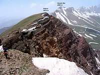
The Rocky Sub-Peaks of Alaneh Sar to the Southeast of its Summit:
 North Face
 South Face
The southeastern ridgeline of Alaneh Sar gives rise to a number of rocky high points. These points make the approach via the top of the ridgeline from the southeast difficult but they can be easily avoided.
 South Face South Face | 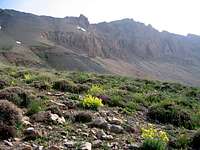 South Face South Face |  South Face South Face |
Views From the Summit of Alaneh Sar:
 Zarrin Kooh Peak