
-
 19901 Hits
-
 91.45% Score
-
 35 Votes
|
|
Area/Range |
|---|---|
|
|
34.47694°N / 119.68005°W |
|
|
Trad Climbing, Sport Climbing, Toprope |
|
|
Spring, Summer, Fall, Winter |
|
|
2500 ft / 762 m |
|
|
Overview
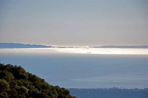 Fog Pouring over the low point on Santa Cruz Island.

Major climbing crags in the Santa Barbara area are spread out in a large section of the Santa Ynez mountains just to the north of the city of Santa Barbara. Santa Ynez Mountains rise steeply from the sea level to an elevation of nearly 4000 feet leaving a narrow strip of land that encompases the cities of Santa Barabra and Goleta. These mountains are, for the most part, covered by heavy manzanita bushes and several other species of plants and trees. Navigating through the brush-covered landscape is extremely difficult, yet many trails have been established for access to different parts of this beautiful wilderness. Certain sections of the Santa Ynez mountains are exceedingly steep exposing underlying rock formations. These particular sections of the Santa Ynez Mountains, namely La Cumber Peak and Cathedral Peak offer great potential to develope into rock climbing crags.
For the past several months I have been writing introductory “Mountain & Rock” pages on the most popular formations in the Santa Barbara area. It has become clear that the only medium that can tie all of these pages together is to write an “ Area & Range” page. This page will encompass most, but not all, of the rock formations in Santa Barbara. I am leaving out all the minor crags as well as all the bouldering areas for future submissions.
I have chosen Gibraltar Rock, the first rock to be explored and climbed in our area, as the central formation with all the rest with either physical or historical connection, as its satellites. Each rock formation in Santa Barbara has its own history, and I have touched upon that history, in varying details, in my “Rock” pages. I will bring some of that history and “Overview” into this page as I deem appropriate. The simple fact remains that an “Area” page becomes a parent page to all its constituents, or “children” as we like to call them at Summit Post. In that capacity I will monitor and administer all the changes, corrections and further submissions to it.
The most accessible rock formations in Santa Barbara area have been developed in varying degrees. That is not to forget the fact that there are many more rock faces yet to be explored and developed. The question of access seems to be the main problem in developing new areas. The hillsides are heavily covered by dry brush, and poison oak seems to rule the land here. I will have separate sections on both forest fires and poison oak near the end of this area page. It is highly recommended that you become familiar with these objective dangers and do your best to avoid them.
 |  |  |  |
History


By all accounts the south face of Gibraltar Rock was the first major rock formation to be noticed and climbed by Santa Barbara climbers in the early to mid nineteen fifties. The earliest of such climbers was Herbert Rickert. He, along with a few friends, did a great deal of cleaning and brush removing to clear a path up this face.
Although the sport of rock climbing had been an accepted and established activity in Europe for centuries, it had not made its way to our little neck of the woods yet. Judging by the old photos, dated back to the mid fifties, people climbed in sturdy city shoes and used goldlines to rock climb.
At the present time the South Face of Gibraltar Rock is clean, and for the most part, solid. Decades of climbing on this rock has broken off most of the loose holds and has created ninety feet of beautiful and fun rock climbing. Many climbers, who went on to climb much bigger and better walls and mountains, trace back their begininnings to this rock.
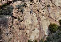
Gibraltar Rock
Gibraltar Rock
 Beta giving Pooch
 Young Climbing Instructor
The south face of Gibraltar Rock would have to be the most popular face in all of Santa Barbara County. These ninety feet of clean, steep and well featured face are the scene of weekend rock climbing classes and enthusiasts alike. I could claim that every inch, or at least every foot, of this face has been climbed on top rope or on lead. However, some sections are void of cracks for placing protection. That fact has not stopped climbers risking life and limb, and in a few cases without a rope or a partner.
Most of the climbs on the south face are moderate, and they range from 5.4 to 5.8. There is one exception, and it’s called The Nose. The Nose is an overhanging hand crack rated 11a. This powerful crack leads to a solid double bolt chain anchor just over the lip.
Upper Gibraltar
Upper Gibraltar
I have written about Gibraltar Rock at length in the past. Once the most accessible rock formations near the road were explored and climbed, it was only natural that the climbers’ attention began to focus on the nearby hillsides for more of the same. Upper Gibraltar was the recipient of that attention and sense of exploration.
Upper Gibraltar turned out to be a large formation with many possibilities. It consists of a two tier system with a right and a left sides separated by a large chimney. The approach in terms of hiking minutes does not seem unreasonable. The main problem is trudging through steep hillsides covered in poison oak. There was an old brush-covered fire road that became the main approach route for many years, hence it received much improvement. The trail led to the top of Upper Gibraltar Rock. What that meant was that you had to rappel down the face and climb back up at the end of the day. At some point in time, this approach to Upper Gibraltar was abondoned. On my last visit to this area, the fire road was so over grown that I could not find it. Nowadays, the approach is made by following the base of Toxic Waste Wall. Be careful. After Toxic Waste Wall, you may run into a lot more poison oak.
All the approach difficulties aside, a number of climbs have been established on Upper Gibraltar Rock. A few of these climbs became classic must-do’s. The Crescent, 5.7 was established in the mid seventies and still is the easiest of the old classics here. The route follows the obvious crescent shaped crack on the upper tier of the formation.
Toxic Waste Wall
Toxic Waste Wall
Toxic Waste Wall was developed by our own local climbers with most of the credit going to Pat. B. This mostly sport climbing formation is one of the satellites of Gibraltar Rock, which in its own right is the most popular rock in the Santa Barbara area. You can park your car on one of the pull-outs along Gibraltar Road and walk down the road two hundred yards to Toxic Waste Wall.
The climbs on Toxic Waste Wall are bolted and have double-bolt anchors on top for rappeling or lowering off. However, due to the sandstone nature of the entire area, the rock is fragile and the flakes tend to break off. Although some of the holds were originally reinforced with Bondo, none were doctored to make the routes easier. You will not find any glued-on holds here. Everything here is natural. Take care of the fragile nature of the routes and you will have a great time.
If you are not in the mood for climbing, you can just kick back and enjoy the awesome views of the Pacific Ocean below your feet.
The Bolt Ladder
The Bolt Ladder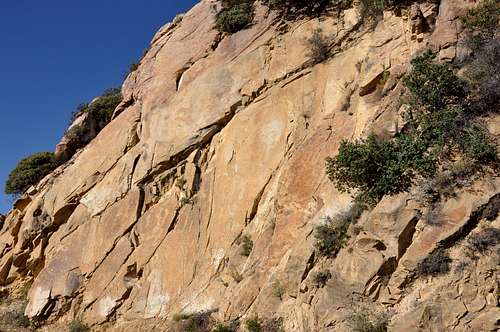
The Bolt Ladder, a satellite of Gibraltar RocK, became popular because of a line of bolts that were put up by two Sierra Club members for a rock climbing class. This way the students learn how to use direct aid to climb a rock. I have istructed climbing partners hauling systems as a rehearsal for wall climbing. I didn’t want to have to shout instructions when we actually got on the wall.
Another reason for popularity of The Bolt Ladder its zero approach status. You have guessed right. It’s situated right next to a mountain road. The lower half of this seventy foot clean sandstone formation is actually a road cut. For many years there was a dirt hill on the base of this rock. With more and more climbers visiting and moving around on the base, the dirt hill is all gone resulting an even larger formation than the original. I have no doubt that rain played a big part in the erosion of the dirt hill as well. Another good deed done by the was to dislodge many loose boulders from half way up the rock. The Bolt Ladder is pretty clean now.
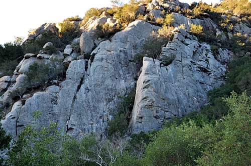
San Ysidro Rock
San Ysidro Rock


San Ysidro Rock is one of the most popular rock formations in the mountains of Santa Barbara, California. Walking up toward the rock will bring you past multi-million dollar houses and mansions. The meticulously groomed neighborhoods will indicate that this must be one of the most pleasant regions in our area, and it is. There is a year-round creek flowing down the canyon and the views from the trails are stunning. The Pacific Ocean lies quietly below your feet, and colorful hillsides please your senses.
All this is just the beginning. You are headed toward San Ysidro Rock. This formation, being an east facing one and being in the shadow of the opposite hill, stays shady all day. There are tall trees on the base providing more protection from the sun, and the nearby stream is just a bonus.
On any weekend you will find many climbers leading or top roping many moderate climbs here. San Ysidro Rock is also used for UC Santa Barbara Outdoor Adventure Program’s rock climbing courses.
By all accounts there are two major formations in the San Ysidro Canyon. The higher formation hardly ever gets visited by climbers. However, the lower formation, which is the focus of this page, seems to get all the attention and glory.
The Lower San Ysidro rock can be divided into two distinct formations separated by a central gully. Through many years of use and countless rainfalls, this gully has become more eroded and difficult to climb or descend. There is another option for getting to the top to set up anchors, or for descending after leading a route. There is a trail on the right side of the formation that leads to the top.
Fire Crags
Fire Crags

Fire Crags are mainly a sport climbing area. The rock, like most rock formations in Santa Barbara area, is sandstone and very fragile. A number of critical handholds broke off during the clean up and establishing routes. The first ascentionists were forced to drill out a few pockets where the holds had broken off. This practice led to a great deal of controversy in the area. However, at the end of the day, Fire Crags became a favorite place for climbers seeking steep and bolted climbs, myself included.
Being west facing, Fire Crags stay in the shade during morning hours making them a desireable place to climb during the warm seasons. Fire Crags sport a number of climbs in the 5.11 range. In addition there are several climbs from a 5.6 to mid 5.10 range.
The most popular climb on Fire Crags would have to be “Grib Dat Hole, 11a.” The beginning move is getting past the lip of the overhang, probably the crux. But, the rest of the climb is sustained at mid 10s. This is a powerful climb that will work your forearms, and leave you with a smile on your face. Grib Dat Hole is drawn in green and labled F.
Some of the easiest sections of Fire Crags are used for rock climbing classes. Heavy duty eye bolts are placed on top of the rock to be used for setting up top rope anchors. In any case, all routes lead to double bolt anchors or double cold-shuts near the top of the rock.
Cold Springs Dome
Cold Springs Dome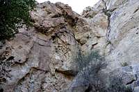
Cold Springs Dome was explored by a local climber named Amos Clifford in the mid seventies. Cutting trials through heavy brush could not have been an easy task. But all the hard work resulted in a great trail that is still in use. In the next twenty years it bacame the rock formation to visit for all local as well as out of town and famous climbers such as Lynn Hill. From the early days of activity to mid nineties many moderate climbs were established on the low angle south face of the Cold Springs Dome. These climbs ranged from 5.8 to 10c.
Most of the attention on Cold Springs Dome was due to its eighty foot overhanging east face. This impressive face is well featured with edges, huacos and cracks. On top of it all, the east face is consistently overhanging for the entire lenght. Climbers with 5.11 ambitions crowded the base and tried the routes on top rope. The first recorded successful free climb of the east face on top rope was accomplished by a visiting climber called Bill Puttnam. The first free climb of this face on lead was on a climb that became known as Makunaima was done by my friend Mike Forkash in 1980.
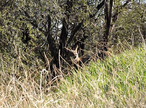
Wild Life
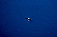 Turkey Vulture
 Just a coyote or a Red Wolf?
 poison oak
The wildlife in the Santa Barbara back country is varied and thriving. We have the usual suspects: bears, coyotes, bobcats, deer, rabbits and variety of birds are ever present. For the past couple months there have been mountain lion sightings, and I personally saw what I think was a red wolf.
Poison oak
Forest Fires
 Aftermath of the most recent forest fire in the mountains of Santa Barbara
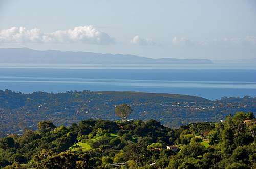
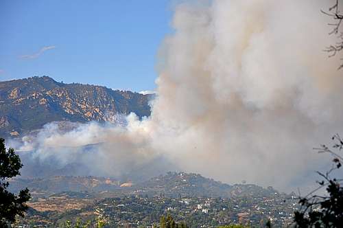
Even though Santa Barbara is a city by the Pacific Ocean, the mountains are, for the most part, arid and very vulnurable to brush fires. These brush fires have resulted in great loss of property, and in some cases, loss of life. The problem with brush fires in the hills of Santa Barbara are exasperated by what’s known as “Sundowners.” Sundowners are the winds that blow from the north east instead of the usual west, the ocean side. As I am writing these pages, hills of Santa Barbara are on fire and many houses have burned to the ground. Brush fires are an ongoing threat. If you are here to climb, make sure to keep an eye on the wind direction and temeratures. You don’t want to be up in the mountains when there is a chance for forest fires. The best seasons are fall, winter and spring.
Camping
Unfortunately, there are no campgrounds close and convenient to Upper Gibraltar.
There is, however, one very large and well developed campground at Cachuma Lake, and a few less developed ones along Paradise Road off Highway 154. There are also a few campgrounds along Highway 101 at El Capitan State Park and Refugio State Park.
El Capitan Beach Camping
Refugio State Beach Camping
Cachuma Lake
How to get there
[img:504492:alignright:medium:]Again, I have chosen Gibraltar Rock as a central and main approach to several of the formations.
From Highway 101 take the Las Positas off ramp. For those coming from the south turn right; for those coming from the north turn left. In either case, drive toward the mountains to the north of Santa Barbara. Continue up Las Positas for .85 miles to State Street, where the name of Las Positas changes to San Roque. Continue driving straight toward the mountains until you come to HWY 192 (Foothill Road) in another .5 mile. Turn right at the intersection and continue up Foothill Road for 1.9 miles to its intersection with Mountain Drive. Turn left onto Mountain Drive and drive for .5 mile to its intersection with Gibraltar Road. Gibralatr Rock is about five miles from this point. You will recognize Gibraltar Rock located to the west of the road when you begin to see a large sandstone formation immediately to your right (east side of the road). This formation is “The Bolt Ladder.”
Gibraltar Rock is just a bit further up the road and to your left. Park in any one of many turnouts in the road.
External Links
Los Padres National ForestWeather
Santa Ynez Mountains
Santa Barbara
Cathedral Peak
La Cumbre Peak