
-
 4347 Hits
-
 78.27% Score
-
 9 Votes
|
|
Mountain/Rock |
|---|---|
|
|
47.54560°N / 11.00324°E |
|
|
Hiking |
|
|
Spring, Summer, Fall |
|
|
6375 ft / 1943 m |
|
|
Overview
 Kienjoch and Kieneckspitze
Kieneckspitze is a summit within the Notkarspitze – subgroup of Ammergau Alps.
This subrange, located in the eastern part of Ammergau Alps, is, with the exception of Notkarspitze itself – which is a quite popular hike from Garmisch-Partenkirchen or Ettal, a rather lonely and remote region.
The highest point of this subgroup is not Notkarspitze but Kienjoch (1953 m) in the western part of the subrange.
Especially in spring and early summer the region is full of innumerable wildflowers and a paradise for those who love them.
Kieneckspitze is the northernmost summit, north of Kienjoch, in the rugged and rocky western arête of the U-shaped Notkarspitze subgroup. This arête is limited in the west by Elmautal, in the east by Kühalpental and in the north by Graswangtal.
Kieneckspitze is an extremely seldom visited summit. There is only a narrow and somewhat exposed trail from Kienjoch, following mainly the arête with some easy rock scramble and only feeble markings. The ascent from Graswang is not signposted, hard to find, steep and narrow, too. So you normally will enjoy complete loneliness on this summit
Getting There
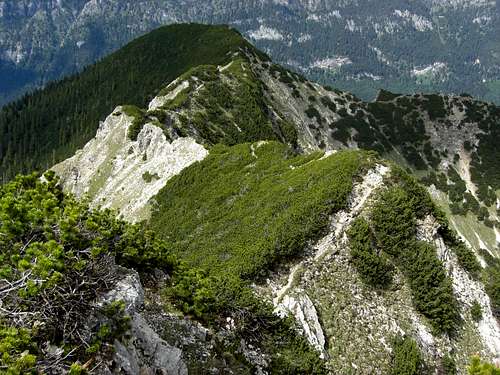
 Kieneckspitze as seen from northeast ridge trail
There are two main trailheads in the valleys:
Graswang in the Graswang / Ammer valley
Use highway A 95 from Munich to its end and follow the road B 2 to Oberau. At Oberau take B 23 to Ettal. After Ettal follow road St 2060 direction Graswang / Linderhof until you reach the eastern part of the little village of Graswang.
There is a little chapel on the right. On the left there is a small parking area in front of the bridge over the creek Linder.
This is the trailhead. Leave your car there.
If the parking area is complete cross the village and follow the signposts to "Wanderparkplatz" (hikers parking area) at the opposite end of the villages (parking fee required). Walk back to the trailhead.
Pflegersee / Garmisch-Partenkirchen
Use highway A 95 from Munich to its end and follow the road B 2 / 23 to Garmisch. It is the right hand road branching off after the Farchant road tunnel.
After the eye-catching Grandhotel Sonnenbichl at the entrance of Garmisch turn right (Thomas-Knorr-Straße) and then right again (Pflegerseestraße). Pflegersee should be signposted. Follow Pflegerseestraße up to the parking area at Pflegersee.
 Daphne striata and Gentiana acaulis Daphne striata and Gentiana acaulis | 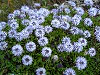 Globularia cardifolia Globularia cardifolia |  Phyteuma orbiculare Phyteuma orbiculare |
Route & Trail Overview
 Kienjoch and Kieneckspitze (right)
Summit route from Graswang
For Hikers
For Mountain Bikers
Western ascent
Eastern ascent
 Lower part of Kieneckspitze northeast ridge
Ascent via northeast ridge trail
Summit Route from Pflegersee
 Upper part of Kieneckspitze northeast ridge
Red Tape
The German part of Ammergau Alps is a protected area (Naturschutzgebiet Ammergauer Alpen). I did not find an official web site of this NP. If you know one, let me know about it.There are no entrance fees or permissions required.
It is forbidden
Ammergau Alps contain many rare plant species, please respect them. Take nice pictures and let them grow.
 Dacylorhiza maculata Dacylorhiza maculata |  Black mountain salamander Black mountain salamander |  White little beauty (Pinguicula alpina) White little beauty (Pinguicula alpina) |
External Links & Accomodations
 A look from Kieneckspitze summit to the south
To find accommodations, try the following homepages:
Ammergauer Alpen
Ammergauer Alpen
Gemeinde Ettal
A good overview and more hiking tips can be found on:
Ammergauer Alpen
Check the current weather conditions here
Maps & Guide Books
 Kieneckspitze as seen from northeast ridge trail
Maps
The most detailed maps are:
Useful hiking map: