
-
 3655 Hits
-
 83.1% Score
-
 16 Votes
|
|
Mountain/Rock |
|---|---|
|
|
47.44257°N / 10.82432°E |
|
|
Hiking |
|
|
Spring, Summer, Fall |
|
|
7149 ft / 2179 m |
|
|
Overview
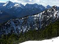
 Pitzenegg as seen from Wiesjoch col
Pitzenegg is one of the summits of Daniel subgroup within Ammergau Alps. With Kohlbergspitze / Zingerstein to the west and Hochschrutte / Plattberg to the east, Pitzenegg is rarely summited for its own. Most people traverse the summit going from Kohlbergspitze to Hochschrutte or vice versa.
Like nearly all summits of Daniel subgroup, Pitzenegg shows two faces: a steep meadow slope to the south, dropping down to Lähn, the main trailhead for this summit, and a steep to perpendicular rockface to the north. Pitzen valley is the northern limitation of Pitzenegg.
The summit itself is a sharp and long, nearly level meadow ridge without a summit cross. A badly marked foot track traverses the summit coming from Wiesjoch col in the east and going down to Zahnjoch col in the west. The Wiesjoch ascent has some exposed but easy rock scramble involved. A nearly unvisible foot track winds up the steep south slopes with again sparse and withered red dots. All in all this seem not too inviting.
But if you look for a lonely autumn hike in a remote and beautiful landscape with a breathtaking mountain scenery, Pitzenegg - as part of a longer traverse - is a good option.
And - maybe - the attached pics are inviting enough to give it more than a thought.
Getting There
 Pitzenegg as seen from Geierköpfe
Main trailheads are
all located in the valley south of the Daniel chain alongside road number 179 of Austria.
You reach these villages
from Munich
from Innsbruck / Sankt Anton
 Pitzenegg and Hochschrutte as seen from Kramerspitz ascent Pitzenegg and Hochschrutte as seen from Kramerspitz ascent |  "Aerial" view of Pitzenegg from Hochschrutte "Aerial" view of Pitzenegg from Hochschrutte |  Pitzenegg (right) and Kohlbergspitze (left) Pitzenegg (right) and Kohlbergspitze (left) |
from Reutte / Lechtal / Füssen
by railway
The “Außerfernbahn” links Garmisch-Partenkirchen to Reutte with railway stations at each trailhead village.
Check the railway schedule here .
Main Routes Overview
Southern ascent: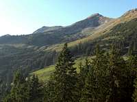 Pitzenegg south ridge ascent route Pitzenegg south ridge ascent route |  Pitzenegg east ridge ascent route Pitzenegg east ridge ascent route |  Pitzenegg upper east ridge route scrambling part Pitzenegg upper east ridge route scrambling part |
Traverse:
Red Tape & Accommodation
 Summit view to the west
There are no special regulations as far as I know.
You find accommodation at:
Mountain huts:
Gear & Mountain Condition
Pitzenegg is a spring, summer and autumn hike on sometimes steep and sometimes nearly invisible foot tracks, sparsely marked with withered red dots.The traverse from Wiesjoch to Zahnjoch needs some easy rock scrambling in exposed terrain. The traverse to Zahn and Kohlbergspitze is in short parts UIAA I climbing.
You need normal hiking gear and good shoes.
 Autumn view to Bleispitze Autumn view to Bleispitze |  Gentiana amarella Gentiana amarella |  A view to Mieminger Berge A view to Mieminger Berge |
Current Weather:
Maps & Guide Book
 Summit view to Hochschrutte, Daniel and Zugspitze
Maps
Guide Book
Alpenvereinsführer alpin
Allgäuer Alpen und Ammergauer Alpen
Bergverlag Rother, München, 2008