
-
 30916 Hits
-
 78.27% Score
-
 9 Votes
|
|
List |
|---|---|
|
|
Overview
There is no shortage of mountains in Argentina. The spine of the Andes follows the western border of the country for 4000 kilometers. Including border peaks that are shared with Chile, Argentina boasts the 5 Highest Peaks in the Andes (including the Top 3 on this list), 8 of the 10 Highest Peaks in the Andes (including the Top 5 on this list), and more than 40% of the 100+ 6000m peaks in the Andes. This is an impressive list and it is almost certain that nobody has completed it. The baseline list will be that proposed by 23 Cumbres. As they first proposed the challenge and they are Argentine, I will respect their selections. Below I will discuss a few debatable issues concerning Argentina's Provincial Highpoint List.
This list includes the three highest peaks in the Andes (1-Aconcagua, 2-Ojos del Salado, and 3-Pissis) and two more in the top ten (7-Llullaillaco and 8-Mercedario). In addition to these five 6000m peaks, there are also two 5000m peaks (Nevado de Chañi and Cerro Bolsón de los Cerillos. It includes several challenging climbs in Patagonia (San Lorenzo, Tronador, Dos Picos, Domuyo), not to mention an intimidating trip to Antarctica (Mount Chiriguano). Additionally, there are two rocky peaks in the Sierras de Córdoba (Champaquí and Cerro de las Ovejas) and one in the Sierra Ventana (Tres Picos). These top fifteen peaks will all feel like real mountains, even if the last few are less serious than the first dozen. The list continues with three fairly unimpressive summits (Negro, Barrancón, Orco Esquina). Finally, as if often the case with politically-derived lists such as this one, five fairly uninteresting jurisdictional highpoints round out the list (Chaco, Formosa, Corrientes, Sante Fe, Entre Ríos).
Compiling this list will be an ongoing project. Nearly two thirds of the peaks on this list are not yet represented on Summitpost. Although I am familiar with most of the regions and some of the peaks, a significant amount of research has been necessary to provide a comprehensive list with descriptions of all the peaks. Photos and route descriptions will be added as they become available to me. I hope to visit some of these mountains over the next few years, at which point I can make pages for the missing peaks. I encourage anybody who may be familiar with some of these peaks to chime in with route information or new mountain pages. Perhaps this list may even inspire some people to visit some of these peaks for the first time.
Before proceeding to the list itself, I would like to cite (and thank) the primary resources that I have used investigate this topic. Obviously, my personal experience helps and there was already lots of good information to be found on preexisting pages on this website. This list was originally dreamed up by the people at 23 Cumbres, an Argentinean website (in Spanish) that is the most comprehensive source on the subject. The website Peakbagger, the best resource for peak lists around the world, was quite useful for locating the peaks themselves and has links to some obscure trip reports. Andes Handbook is a Chilean website (in Spanish) that has excellent mountain/route content for the Andes. Finally, John Biggar is the authoritative resource for peak information throughout the Andes, especially when it comes to determination of elevations.Debatable Provincial Highpoints
Buenos Aires (Capital Federal)
The first point-in-question is the highpoint of the Capital Federal; the city of Buenos Aires. The name Buenos Aires both refers to the province and the city by that name. The city of Buenos Aires is entirely within the Province of Buenos Aires and is technically a part of that province. However, in many ways, Capital Federal is governed as a separate entity. 23 Cumbres does not include it in their list, as there are only 23 provinces within Argentina. Peakbagger does include it and I have left it here as an optional 24th peak. At 38m, the site is occupied by the city's municipal water company and is rather uninteresting.
Tierra del Fuego
The second point-in-question concerns Tierra del Fuego. The root of this debate lies with Argentina's claim to territory in Antarctica. Both Argentina and Chile have territorial claims over slices of Antarctica. The international community disputes these claims and, in fact, an international treaty has been signed saying that Antarctica does not belong to any nation. Neither Argentina nor Chile have signed this treaty, and both countries maintain a significant presence on Antarctica itself. The Argentine military controls significant chunks of that continent and the Argentine's play a significant role in both the research and the tourism that take place on Antarctica. If you support the Argentine territorial claim in Antarctica, then Mount Chiriguano is Tierra del Fuego's Highpoint. If not, that honor reverts to Cerro Cornú on the mainland. I take no stand on this debate. I will respect the inclusion of Chiriguano on the 23 Cumbres list, but I will include Cornú as an alternative.
Islas Malvinas (Falkland Islands)
The final debate concerns the Islas Malvinas (a. k. a. Falkland Islands). Argentina refers to these islands as the Islas Malvinas and claims them as their territory. The United Kingdom has controlled these islands for decades, does not respect Argentina's claim, and calls them the Falkland Islands. A war was fought between the two countries some thirty years ago over control of this territory and Argentina continues to posture over the ownership of these islands. I am not sure what the provincial/territorial status would be if they were in fact under Argentine control. Again, I take no stand on this controversy, but I do mention it for thoroughness. The 23 Cumbres list does not include them, but I will again list there highpoint of Mount Usborne (alternative Argentine name?) as an optional 25th peak.
The List
| # | Mountain | Province | Elevation |
| 1 | Aconcagua | Mendoza | 6962m |
| 2 | Ojos del Salado | Catamarca | 6893m |
| 3 | Mount Pissis | La Rioja | 6793m |
| 4 | Cerro Llullaillaco | Salta | 6739m |
| 5 | Cerro Mercedario | San Juan | 6720m |
| 6 | Nevado de Chañi | Jujuy | 5930m |
| 7 | Cerro Bolsón de los Cerillos | Tucumán | 5550m |
| 8 | Volcán Domuyo | Neuquén | 4709m |
| 9 | Mount San Lorenzo | Santa Cruz | 3706m |
| 10 | Mount Chiriguano | Tierra del Fuego (Antarctica) | 3660m |
| 11 | Cerro Tronador | Río Negro | 3491m |
| 12 | Cerro Champaquí | Córdoba | 2770m |
| 13 | Cerro Dos Picos | Chubut | 2525m |
| 14 | Cerro de las Ovejas | San Luis | 2260m |
| Cerro Cornú | Tierra del Fuego (Mainland) | 1490m | |
| 15 | Cerro Tres Picos | Buenos Aires | 1239m |
| 16 | Cerro Negro | La Pampa | 1188m |
| 17 | Barrancón | Misiones | 835m |
| 18 | Orco Esquina | Santiago del Estero | 790m |
| Mount Usborne | Islas Malvinas (Falkland Islands) | 705m | |
| 19 | Chaco Highpoint (Taco Pozo) | Chaco | 272m |
| 20 | Formosa Highpoint | Formosa | 239m |
| 21 | Corrientes Highpoint | Corrientes | 236m |
| 22 | Santa Fe Highpoint | Santa Fe | 137m |
| 23 | Entre Ríos Highpoint | Entre Ríos | 119m |
| Buenos Aires City Highpoint | Ciudad Autónoma de Buenos Aires | 38m |
Aconcagua (6962m) - Mendoza
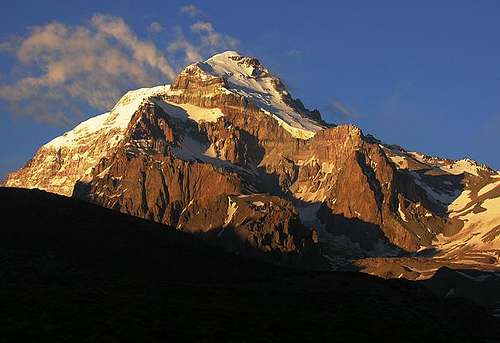
Photo by William Marler
Aconcagua, the highest summit in America (South, Central, or North) is Argentina's most famous mountain. Interestingly, despite being the highest, this is almost certainly the most popular peak on this list... well, I guess that's because it is the highest. Although technically a walk-up, at nearly 7000m, this is a serious mountain, one on which several people die each year. I believe the peak hosts the largest base camp in the world other than Everest. During the summer months, thousands of climbers flock to the mountain, despite climbing fees that are as high as $1000 during high season. Most people hire mules for the two day trip to base camp, then ferry loads to two or more high camps on the mountain. Crampons and ice axe are generally necessary to reach the summit, but no other technical gear is needed on the normal route. However, don't take this mountain lightly, as the high altitude makes it a very serious undertaking. The weather can be extremely cold and, if the weather doesn't cooperate, there is nothing trivial about this mountain at all.
Ojos del Salado (6893m) - Catamarca
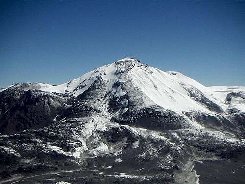
Photo by Corax
Ojos del Salado, the second highest mountain in the Andes, is also the highest mountain in Chile and, reputedly, the highest volcano in the world. The summit straddles the international border between Argentina and Chile and can be reached from either side. In fact, technically there are two summits, an Argentine summit and a Chilean summit. Supposedly, the Chilean summit is 50cm higher, but who really knows. Both summits require a short pitch, of fairly loose, mildly technical scrambling / rock climbing. Given the altitude and the remoteness, most parties choose to belay this final summit pitch. Everything below the summit pitch is non-technical, but snow gear is necessary, and the cold and the altitude make this a serious undertaking. Approaching from Chile allows for a shorter approach and use of a mountain hut, but the permitting is more complicated and more expensive. Climbs from Argentina are less common and require a longer approach, but there is much more solitude and no red tape. Additionally, a new 4x4 track to the base of the mountain, has made access from Argentina much easier than in the past.
Pissis (6793m) - La Rioja
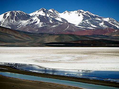
Photo by Corax
Mount Pissis, the third highest mountain in the Andes, is actually on the border of La Rioja and Catamarca. Located roughly 50 kilometers south of Catamarca's high point Ojos del Salado, Pissis is hardly overshadowed by its next highest neighbor. Ojos del Salado may be taller, more popular, and more famous, but Pissis is more complex, more glaciated, and arguably more impressive. The Pissis massif includes at least five different summits with at least 200m prominence, it boasts the only significant glaciers in the Puna de Atacama, and there are several interesting alkaline lakes surrounding the peak. The common approach from Argentina involves 100 kilometers on a rough 4WD road. Access from Chile is also possible, although reportedly even more complicated. The ascent is still non-technical, but probably more challenging than any of the other major peaks in the Puna de Atacama. As usual in this region, expect cold temperatures, strong winds, and high altitude in a remote environment.
Llullaillaco (6739m) - Salta
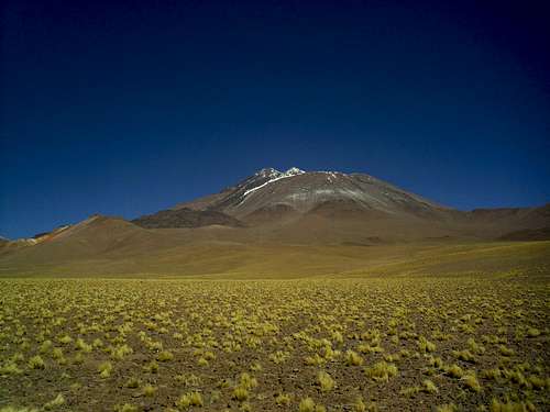
Photo by Fabrice Rimlinger
Llullaillaco, the seventh highest peak in the Andes and the sixth highest in Argentina, is a high remote mountain located in the northwest of Argentina. Llullaillaco is famous for having the highest archaeological site in the world. In fact, if you go to the High Mountains Museum in Salta (Capital), you can see the remains of the Inca mummy found near the summit. Like many of the high peaks in northern Argentina's Puna de Atacama, this is a non-technical climb, but it is at very high altitude and can be quite cold. It is accessed via an extremely remote border pass, seldom visited, and only accessible via lengthy 4x4. Furthermore, water can be complicated to find in this high, dry desert, so make sure to be prepared.
Mercedario (6720m) - San Juan
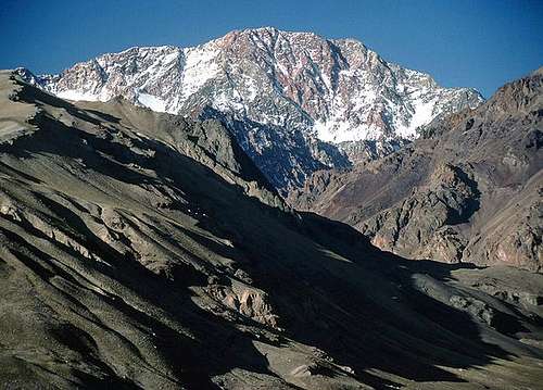
Photo by William Marler
Mercedario, another monster peak, is the seventh highest peak in Argentina and the eighth highest peak in the Andes. In fact, in the Andes, outside of the Puna de Atacama, only Aconcagua and Huascarán Sur (Peru) are higher. This part of the High Andes is generally much colder than the Puna de Atacama, receives far more precipitation, maintains more significant glaciers, and involves steeper terrain. Mercedario is easily visible from Aconcagua's Camp Nido de Condores and, in many ways, is a very similar peak. The climbs require similar approaches, both peaks have at least one non-technical route, and the weather conditions are comparable. Mercedario is some 250m lower, but probably receives fewer than 1% of the visitors, and there are no peak fees. However, it is extremely remote and you will have little assistance in case of emergency.
Nevado de Chañi (5930m) - Jujuy
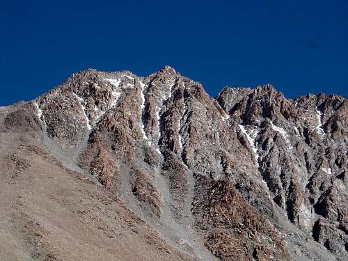
Photo by Silvio1973
Nevado de Chañi, located in the far northwest corner of Argentina on the provincial border between Jujuy and Salta, is technically part of the Puna de Atacama, but in many ways is quite different than the other peaks in that group. Apparently, it has a granitic base that is unlike nearly all other peaks in the area. As a result, the peak has a number of potential technical routes to the summit. Nonetheless, there is still an easier non-technical route that can be reached within a few days, but it involves over 4000m of elevation gain. Nevada de Cachi also differs from the other main Puna peaks in that it is offset several hundred meters from the crest of the Andes on the border with Chile. It is also far enough north that it is starting to be influenced by the Boliviano Invierno and, therefore, best climbed during the Argentine spring before the rainy seasons arrive. Nevado de Chañi is also of interest culturally. Inca ruins were found on its summit and it is also located near the Quebrada de Humahuaca, home of what is arguably the most in tact indigenous culture in Argentina.
Cerro Bolsón de los Cerillos (5550m) - Tucumán
So far, I have been unable to find much published information about this mountain despite it being a major feature fairly close to the several cities. On or near the Tucumán/Catamarca provincial border, this appears to be the highpoint of the ridge that separates the two provinces, roughly halfway between San Miguel de Tucumán and San Fernando del Valle de Catamarca. I'm fairly certain that I've seen it from near Amaicha del Valle. I recall a gentle, but prominent ridge with a minor snow cap. I'm not sure if it would be accurate to refer to this as part of the pre-Cordillera or perhaps a Cordillera Oriental, but this peak is part of a ridge that is fairly distinctly separated from the main Andes chain. In fact, Cerro Bolsón de los Cerillos lies over 200km almost due east of Ojos del Salado. With over 3000m of prominence, this peak is one of the 100 most prominent peaks in the world, on this list only surpassed by Aconcagua, Ojos del Salado, and Mercedario. So, we're talking about a big mountain. I don't have any route information, but I imagine it requires a long, dry, presumably non-technical ascent, potentially facilitated by some of the active mining roads in the area.
Volcán Domuyo (4709m) - Neuquén
Volcán Domuyo is sometimes referred to as Patagonia's highest peak, but this is mostly just a technicality. Neuquén may be a little far too north to be considered Patagonia, but it does represent a fascinating transition between the higher, dryer peaks of central Argentina and the lower, wetter, glaciated peaks in southern Argentina. Unique vegetation and hot springs abound in the area and it is seldom visited by foreigners. Public transportation to the region is limited, but you can drive to within a couple days of the peak. The ascent is supposedly non-technical, but there are reportedly numerous accidents, presumably because people get lost on the peak. Surprisingly, there is not yet a page here on Summitpost, but Andes Handbook has some good information on the peak. It would probably make an excellent ski descent in winter.
Mount San Lorenzo (3706m) - Santa Cruz
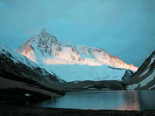
Photo by Monika via Nikman
Mount San Lorenzo is the first true Patagonian peak on this list. It is situated on the Argentina/Chile border somewhere between the Northern and Southern Patagonian Icecaps. Although it is not part of either of these icecaps, I believe that it is home to the third largest mass of ice in mainland Patagonia. The easier routes are accessed from Chile, involving a couple days of hiking and a challenging roped, glacier climb rated at AD. A number of technical mixed routes have been opened on the Argentine side in recent years. This is another peak in a very remote area, but this time it's not surrounded by a dry, waterless desert, but instead a wet, muddy, temperate rainforest. The weather in this area is notoriously unpredictable, so be prepared for rain and snow, and be prepared to wait for a good weather window, then go for it.
Mount Chiriguano (3660m) - Tierra del Fuego (Antarctica)
I believe that Mount Chiriguano is actually located in Antarctica. As mentioned earlier, Argentina claims a portion of the continent of Antarctica as its own territory. I believe that this territory is considered to be part of the province of Tierra del Fuego. If one supports this claim, it seems like Mount Chiriguano is the highpoint of Argentine Antarctica making it Tierra del Fuego's highpoint. I believe that this is the logic used by 23 Cumbres in placing this peak on their list. At this time, I don't have any other information about this mountain, not even its precise whereabouts. I will add more information when I find it or somebody presents it to me. An alternative mainland Tierra del Fuego highpoint (Cerro Cornú) is discussed below.
Cerro Tronador (3491m) - Río Negro
Photo by Fabrice Rimlinger
Cerro Tronador is a massive volcano on the international border halfway between Bariloche, Argentina and Osorno, Chile. It is the centerpiece of Argentina's Nahuel Huapi National Park and Chile's Vicente Rosales National Park and the highpoints of both the Río Negro province and the Los Lagos region. The mountain actually has three main peaks, the Argentine, the Chilean, and the International. The International Peak is the main summit and probably the most difficult of the three, rated at AD/D. Access from Argentine is easy. A short daily bus ride, followed by a half day walk, leads to a mountain hut at the base of the glacier. From there, a the summit can be reached in a long day. Ascents from Chile are more difficult due, among other reasons, to lengthy approaches. Tronador is a popular trekking destination. Summit attempts are more common on the Argentine summit than the International summit. The Argentine military even uses the mountain for training to prepare for duty in Antarctica.
Cerro Champaquí (2770m) - Córdoba
Cerro Champaquí, Córdoba's highpoint, is the first peak on this list that is not part of the Cordillera de los Andes. If you look at a topographical map for the entire country of Argentina, the Sierras de Córdoba immediately sticks out as the only significant range other than the Andes. Nowhere near as high or extensive as the Andes, the Sierras de Córdoba host a wide range of peaks, creeks, and woods. The city of Córdoba is a musical and cultural center and the surroundings towns in the sierras are quaint and fun. There are numerous peaks to climb and a few popular rock climbing locales in the area. Cerro Champaquí is easily accessed from several different sides. Most of the routes require a long day or an overnight. There may be a hut that you can stay in. Alternatively, a rough jeep trail climbs to the summit ridge and within 15 minutes of the peak itself.
Cerro Dos Picos (2525m) - Chubut
It sounds like Cerro Dos Picos, Chubut's highpoint, has only been climbed a handful of times. Located near Cholila, a little bit north of the provincial capital of Esquel, this mountain is in a little explored area of northern Patagonia. Access is best via the west side of Lago Cholila. A boat can save a couple days worth of hiking. Upon crossing the lake, the valley of the Río Tigre leads to the base of the peak. The peak is quite steep and is notorious for poor quality rock. There is a large glacier on the mountain, but it is unclear if the route crosses said glacier. This region is generally quite wet and access can be complicated by thick brush. Note that this peak is not to be confused with Cerro Tres Picos, a somewhat more well known peak also in Chubut, more or less due east of Cerro Dos Picos. Cerro Tres Picos is a prominent peak east of Highway 40 in Cholila, while Cerro Dos Picos is west of Cholila and Highway 40. There are also several heavily glaciated peaks on the international border further to the west of Cerro Dos Picos. Apparently, none of them rise higher than Cerro Dos Picos, at least not on the Argentine side of the border.
Cerro de las Ovejas (2260m) - San Luis
Cerro de las Ovejas, the San Luis highpoint, is still part of the Sierras de Córdoba. Most of this range is actually within Córdoba, but in spots the west side sneaks into San Luis. There is some debate about whether the true highpoint is Cerro de las Ovejas or nearby Cerro Divisadero. The uncertainty is due to surveying imprecision, not boundary issues. For the time being, we'll assume that Cerro de las Ovejas is the highpoint, but Cerro Divisadero is only 5 kilometers away if you want to tag both, just in case. The climb is entirely non-technical. If you take the 4WD road, it's a short walk. Otherwise, it can be done in a long day or a quick overnight.
Cerro Cornú (1490m) - Tierra del Fuego (Mainland)
If you support the international community's view that Antarctica is not owned by any nation, then Mount Chiriguano does not qualify as the highpoint of Tierra del Fuego, despite effectively being under Argentine control. Restricting Tierra del Fuego to the South American continent leaves Cerro Cornú as the provincial highpoint. I don't know a whole lot about this peak either. It appears to be located about 30 km east of Ushuaia, but within about 5 km of a road. Anything in that region can be expected to be steep and heavily glaciated, even at relatively low elevations. The weather is extremely windy, wet, and unpredictable. I am hopeful that I'll be able to find more out about this peak so that I can describe it in more detail soon.
Cerro Tres Picos (1239m) - Buenos Aires
Cerro Tres Picos is the highest peak in the province of Buenos Aires. It is actually located several hundred kilometers of the city of Buenos Aires in a fairly rural area well to the interior of the coastal city of Mar del Plata. Naturally, should not be confused with either Cerro Dos Picos or Cerro Tres Picos in Chubut. Cerro Tres Picos is part of the Sierra de la Ventana, just north of Bahia Blanca at the southern end of the province of Buenos Aires. This is one of several scenic small ranges in the area. Sierras del Tandil, although significantly lower, are also supposed to be quite nice. The normal route begins on private property at the Estancia Funke. Access provided for a reasonably cost with prior registration. The Estancia is located between the towns of Tornquist and Villa Ventana. The zone can be reached two times per week by overnight train from Constitución in Buenos Aires. From Estancia Funke, the climb can be completed in one long day or an overnight. There is also a new, challenging route called the El Condor Pasa. The 23 Cumbres Website (in Spanish) has the best information available on the web.
Cerro Negro (1188m) - La Pampa
La Pampa is the true breadbasket of Argentina, generally known for fields of wheat and cattle. The region was initially thought to be a flat desert until the underground water sources were understand. In fact, while many parts are flat, others have rolling hills. One such undulating area is in the northwest of La Pampa, close to the province of Mendoza, where you will find Cerro Negro. No doubt there are numerous Cerro Negros in Argentina. I am familiar with one in Río Negro and one in Neuquén, but there must be others. La Pampa's Cerro Negro is by no means the most impressive, but it is the provincial highpoint and it can give you a reason to stop in an interesting region that most people just pass through. From the town of Algarrobo del Aguila, head nearly 100 km towards the town of Agua Escondido in Mendoza to reach the Puesto Cerro Negro. The summit is easily accessible, but you will need to ask permission first. For more detailed information that will actually get you to the highpoint, check of the 23 Cumbres Website (in Spanish).
Barrancón (835m) - Misiones
Misiones is the province that occupies the northeast corner of Argentina. Bordering both Brasil and Paraguay, best known for the international tourist destination of Iguazu Falls, in many ways, Misiones feels more like Brasil than Argentina. The semi-tropical rainforest of the region is unlike any other part of the country and is heavily threatened by intensive logging and plantation forestry. Many people speak a sort of Portañol, a mixture of Spanish and Portuguese. There are many people who even speak Guaraní, the indigenous language in Paraguay. Barrancón, the highpoint of Misiones, can be found near the Argentina border town of Bernardo de Irigoyen, right next to the Brasilian towns of Barracão and Dionísio Cerqueira. Barrancón can be reached by a short easy walk easily accessible from Highway 14 (or 17?). The city water tank is on the actual highpoint in front of school #604. For details, see the 23 Cumbres Website (in Spanish).
Orco Esquina (790+m) - Santiago del Estero
This one's quite a mess. Everybody agrees on the name of Santiago del Estero's highpoint, but nobody seems to have any idea where it is actually located. The23 Cumbres Website (in Spanish) discusses the confusion, suggesting three possible candidates. The first is in the sierras de Sumampa near the provincial border with Córdoba, but this is quickly eliminated because it's elevation is only ~580m. The second candidate is in the sierras de Guasayán near the provincial border with Catamarca and Tucumán. Although measured at only ~720m instead of the recorded 790m, 23 Cumbres suggests that this is the actual highpoint and it is near the town of Sol de Mayo. The third alternative, which is that selected by Peakbagger, is in a flattish area in northwestern Santiago del Estero near the provincial border with Salta. Both sites agree that there is a point in this area that reaches >800m in elevation. However, 23 Cumbres disqualifies this location (for the time being), arguing that the provincial border is not precisely defined in this zone. Whichever of these highpoint candidates you choose, you are likely to encounter a fairly unexciting, nondescript location, but touch them both and you can (reasonably) confidently say that you've climbed Orco Esquina.
Mount Usborne (705m) - Islas Malvinas (Falkland Islands)
I'm not sure why I've even included this peak in the list. I suppose it's only a matter of Argentine national pride and, of course, I'm not even from Argentina. Nonetheless, one could make the argument that the Islas Malvinas rightfully belong to Argentina, thus making this a territorial highpoint of sorts. Of course, they are very clearly under British control and called the Falkland Islands by their current residents. Nonetheless, apparently Mount Usborne is the highpoint of said territory. Unfortunately, I don't know anything at all about this controversial highpoint, but I suspect it to be a fairly easy climb. It appears to be within about 1 km of a reservoir, so it should be fairly accessible be road.
Chaco Highpoint (272m) - Chaco
The Argentine province of Chaco is as flat as they come. There are no good surveys that specify the true highpoint of the province. The best determination of the highpoint to date is based on the following logic proposed by 23 Cumbres. The highest topo line on the map is an arc that connects a point on the provincial border with Santiago del Estero and a point on the provincial border with Salta, isolating the highpoint to a >600 square kilometer area at the western extent of the province. Observation of the direction of flow of the rivers in this region suggests that the highpoint is at the Salta-Chaco border, near Ruta 16 and the town of Taco Pozo. There is another candidate a few kilometers north of here. However, until a proper technical survey is completed, nobody really knows.
Formosa Highpoint (239m) - Formosa
The Formosa highpoint has been identified with more confidence than that of Chaco, but it is similarly inglorious. Much like Chaco, Formosa is almost entirely flat, with an imperceptible slant that ascends as the province extends westward. According to 23 Cumbres, the provincial highpoint can be found atop a minor rise near the border with Salta just south of the Pilcomayo River. The highpoint can be reached from Formosa via the property of a certain María Cristina or from Salta via the Alto La Sierra ranch.
Corrientes Highpoint (236m) - Corrientes
Apparently, Corrientes has only one area, near the town of La Cruz, that boasts even modest peaks. There are three of them, in fact: Cerro Chico, Cerro Capará, and Cerro Nazareno. Most people in Corrientes mistakenly think that Cerro Nazareno is the provincial highpoint, but it is not. That honor goes to an otherwise insignificant hill near the border with the province of Misiones which is to be found near the road that connects the town of San Carlos with Ruta 14. This spot is near the base of the Sierras de San José that are located predominantly in Misiones. This information all comes from 23 Cumbres, so feel free to doublecheck there. Peakbagger can help provide you with a map of the area.
Santa Fe Highpoint (137m) - Santa Fe
The Santa Fe Highpoint actually has several potential candidates in fairly disparate locations. For the time being, 23 Cumbres believes that the provincial highpoint is atop a small hill that lies in the field cultivated by a certain Señor Tossi. This site is located in between the following towns: San Ricardo, Santa Fe; Villia Eloisa, Santa Fe; Armstrong, Santa Fe; and Cruz Alta, Córdoba. One debunked potential candidate is a point on the border with Santiago del Estero that is listed as the highpoint in the Firestone roadmap with a published elevation of 133m. The other potential candidate is a point near the town of Arias, Córdoba that has been listed as high as 142m on certain maps, but has not yet been investigated fully. For the time being, the highpoint is listed as the 137m point near Armstrong, but this is one that may be proved inaccurate if and when further detailed surveys take place.
Entre Ríos Highpoint (119m) - Entre Ríos
Like Santa Fe, the true highpoint of Entre Ríos is still unclear. This time, there is agreement that the highpoint is located somewhere in between the towns of Crespo, Camps, Villa General Ramirez, and Aranguren. All four of the towns seem to be near Ruta 12, but 23 Cumbres refers to a Ruta 19, I'm not sure whether or not that is in error. Regardless, there are several candidates. The top candidate appears to be a spot near the railroad in Camps, but there are also potential candidates somewhere between Camps and Villa General Ramirez, as well in the town of Aranguren. The following trip reports by Andrés Espindola (Spanish) and Dennis Stewart (English) may provide some guidance, or maybe they'll just confuse you more. Either way, to tag the Entre Ríos highpoint, you'll have to go there yourself, choose one or several potential spots, and declare success to whatever degree of certainty makes you most comfortable.
Capital Federal Highpoint (38m) - Ciudad Autónoma de Buenos Aires
The Buenos Aires city highpoint is not mentioned by the folks at 23 Cumbres. The city of Buenos Aires is part of the province of Buenos Aires, which has the 1239m Cerro Tres Picos as its highpoint. However, in many ways, Capital Federal (the municipality of Buenos Aires) is a separate political unit, so its highpoint will be included here for completeness, even though it is not strictly required to complete the 23 Cumbres challenge. The Buenos Aires Capital Federal highpoint is located within barrio of Villa Devoto. Again, there seems to be a slight bit of uncertainty, but all reports put the spot within a couple city of blocks of one another. Interestingly, the reported elevation of said site seems to vary by as much as 10m. Once again, Dennis Stewart has helped us with his trip report. Based on the coordinates provided at Peakbagger, he located the highpoint at the city's municipal water distribution center. This building seems to occupy the square block between the following streets: Avenida Francisco Beiró, Jose Pedro Varela, Mercedes, and Gualeguaychú. However, a website from the barrio of Villa Devoto (in Spanish) confidently places the city's highpoint at the interesection of Avenida Francisco Beiró and Calle Chivilcoy, about a block away from the city's municipal water distribution center. Interestingly, this source states that the highpoint has been accurately measured at roughly 27m, considerably lower previously reported. In all likelihood, this barrio Villa Devoto website is probably the definitive source.