
|
|
Mountain/Rock |
|---|---|
|
|
47.59563°S / 72.30635°W |
|
|
Hiking, Mountaineering, Ice Climbing, Skiing |
|
|
Summer, Winter |
|
|
12159 ft / 3706 m |
|
|
Overview


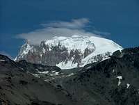
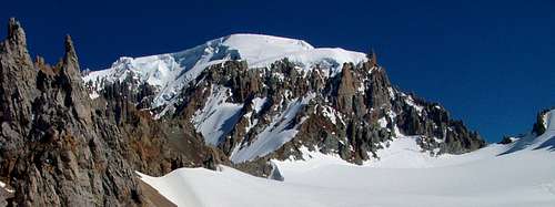
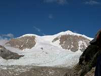
At 3706m Cerro San Lorenzo is the second highest peak in the Patagonian Andes. It´s a huge mountain range with a mainsummit guarded by long ridges that connect two minor summits (Cumbre Sur, 3385m and Cumbre Norte, 3567m).
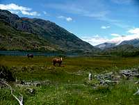
The mountain rises about 3300 meters out of the flat Patagonian surroundings.
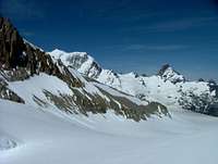
The range is packed with glaciers. The weather on the mountain is rarely stable.
MOUNTAINEERING
The mainsummit can be climbed from Chile on the normalroute, the so called "routa de Agostini", named after the first climber - Padre de Agostini - in 1943. Agostini was already 60 years old when he first climbed Cerro San Lorenzo, but had done a lot of pioneerwork mountaineering in Patagonia before.
The second option is climbing the eastridge from the Argentinian side. This route is technically much more challenging than the normalroute.
A third option from Chile is an approach along "Rio del salto" to reach the huge lagoon at the end of mighty "Glaciar calluqueo". Then follow the right side of the glaciar's moraine and turn right into the ice flank to gain the southridge. The southsummit will be traversed to the east to follow the ridge to the mainsummit. I heard about this option from a Chilean friend, but don't know more details about it, so I can't give a very exact desciption and nothing is mentioned about it under "Routes" further down. From what I know this route has become an interesting alternative to the Agostini route in summer, since melting glaciers and big open crevasses sometimes make the Agostini route impossible in summer. For more details on this get into contact with Terra Luna Lodge, who offer guided ascents to Cerro San Lorenzo, linked in the Link-section further down.
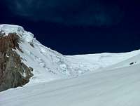
The fourth option is most difficult: the north coloir that leads directly to the main summit is an extremely difficult ice route. It was climbed by Barmasse, Bernasconi, Lanfranchi, and Ongaro (Italy) in 2006. They called the route: Café Cortado. There is a picture in the gallery, which shows the east-ridge in profile and the north coloir from top to bottom.
TREKKING
Trekkers used to surround Cerro San Lorenzo and reported the circle around the mountain is astonishing. Since someone has to cross Argentine/Chilean borders twice this circle is barely legal although not everybody cares for that. Don´t expect to meet anybody for 10 days if you go there!
Getting There


Cerro San Lorenzo can be reached through Cochrane from the Chilean side.
Cochrane is one of the last small villages on the so called "Carretera Austral", a dust and gravel road that crosses the Chilean side of Patagonia. Public transport on that road is rather uncommon for the whole distance of more than 1000 kilometers. It is possible to use public transportation from town to town, but that takes time and it´s not very reliable.
To rent a 4x4 truck is a good option in that area.
Another way is flying in from Santiago de Chile or Punta Arenas. The nearest airport is called Balmaceda. It is served by LAN-Chile and lies some kilometers outside the town of Coihaique. Take a bus to Coihaique. From Coihaique it´s possible to take a bus to Chochrane.
From Chochrane a bad in shape road heads to Fundo San Lorenzo. It should be possible to organise a transport at least for a part of this road in the small tourist office in Cochrane.
From Fundo San Lorenzo it is another walk to the Agostini Base Camp.
At the BC there is a wooden hut the so called Ref. Toni Rohrer. It is named after a Swiss alpinist who died on a try to climb the ice mushroom that appears on top of the summit.
To reach the mountain from the Argentinian side is not easy eather. The nearest Argentinian airports are Bariloche in the north and El Calafate in the south. Both are more than 500 kilometers away.
Bariloche and El Calafate are connected on a north-south gravelroad by the legendary "Routa 40".
There are frequent buses on that road, but a 4x4 truck is always the best option around there.
The Argentinian side of the mountain is a National Park called "Francisco Perito Moreno". Don´t mix that up with the Moreno-Glacier near El Calafate (that is located far more south).
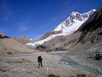
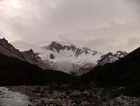
For going to Perito Moreno National Park you have to leave the "Routa 40" at a crossing called "Las Horquetas". From there a road heads northwest and leads to El Rincon. A track follows the eastern part of the valley to "Puesto San Lorenzo". From "Puesto San Lorenzo" it is about 8 more kilometers until you reach a lagoon that lies directly under and between the peaks of Cerro San Lorenzo and Cerro Hermoso (2500m).
This is the basecamp for climbing the eastridge of Cerro San Lorenzo.
Hans Bräuner-Osborne (SP-member hbrauner) sent me the following information in August 2008 after having tried a winter ascent of the Northern East face: "We actually managed to approach the mountain from the Argentinian side and had no access problems from via the Rio Oro valley (but had a lot of trouble trying to get in via the Perito Moreno national park)"
He reports problems when wanting to enter the park in winter. The park rangers refused him to enter the park with a 4x4 car.
Red Tape

If you want to climb Cerro San Lorenzo you should inform the local police station at Cochrane before you go.
Back in 2004 there were no fees for climbing the mountain.
Camping


You can camp at Fundo San Lorenzo but have to contact the friendly people (Soto family) who own the ground. They also provide food if wanted.
The Fundo San Lorenzo is a worth to go place even if someone has no aims in climbing Cerro San Lorenzo summit.
There are all kind of cute animals that share the camping ground with you.
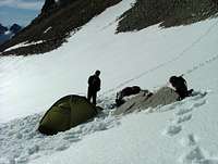
At Agostini BC it is possible to sleep inside Ref. Toni Rohrer, a simple wooden hut with a small stove inside. As an alternative you can build up a tent some hundred meters above at the side of a lagoon. Except of the Soto family that might bring some food with horses if arranged there is no logistical help here.
There are no facilities at the Argentine BC.
External Links


Andeshandbook is the best link I know that provides some useful information on the normal route although the information is all in Spanish:
www.andeshandbook.cl
Credits for the sattelite image I used here go to NASA. The orignal image can be watched at NASA homepage next to a lot of other interesting information:
http://www.nasa.gov
http://earth.jsc.nasa.gov/debrief/ISS001/topFiles/ISS001-E-5113.htm
Terra Luna Lodge offers guided ascents to Cerro San Lorenzo:
http://www.terraluna.cl/
Trip report from Hans Bräuner-Osborne:
http://www.climb.dk/blog/2008/07/cerro-san-lorenzo-part-1-getting-there.html
Youtube video climbing the route "Cafe Cortado" (excellent):
>www.youtube.com/watch?v=XD_b_0mO_fw
Routes

1. Normalroute from Chile (Agostini)
Total climb of approx. 3100Hm from Agostini BC situated at 1000Hm including 400Hm re-elevation at Paso Comedor and Glaciar Calluqueo. Total distance about 15 kilometers.
Usually there will be done two camps at 2000m and 2500m.
Difficulties/Grade:
The normalroute does not have severe technical challenges exept of a short and steep ice-passage (a 45 to 55 degree serac-zone) when climbing the Humbro Norte after camp2. The conditions can vary in this section from year to year and also within a season. There are dangerous crevasses when crossing Glaciar Calluqueo. In a losing sight situation orientation on the wide Glaciar Calluqueo can lead to unhappiness. Bringing a GPS is a very good idea. Considering all difficulties like total lengh and exposition of the route I would rate the normal route between PD+ and AD- compared to the Alpine ranking system and similar peaks I have done in the Alps.
Do not underestimate the physical challenge of this climb and the easily changing Patagonian weather!
2. Eastridge from Argentina
After serveral unsuccesful attempts first achieved in 1986 by P. Fatti, E. Müller, R. Dodding and H-P. Bokker. It took them 8 days to go up and 4 days to come down again on the same route.
Total climb of approx. 2700Hm from Rio Lacteo, 2000Hm from the Glacier. Total lenght of the ridge about 3000 meters.
Difficulties/Grade:
TD+, ice and mixed
Repeated 1987 by C. Ferrari, D. Valsecchi, A. Borghetti and M. Villa in a total time of 6 days up and down on a more direct line up the ridge with rock up to Grade V.
When to go
The best time for an alpinestyle climb is from late December to late February.
The characteristic of the normal route makes it possible to do it on ski. I was told that the Patagonian winter sometimes has less wind than the summer although the days are much shorter.
Skimountaineering should be possible from June to Oktober.
Map


Baarb - Feb 19, 2012 11:09 pm - Hasn't voted
Extra picsHi, this user has some photos from San Lorenzo but hasn't attached them. Perhaps they will be of interest. http://www.summitpost.org/users/drew-aaron/30567. Cheers.
Nikman - Feb 20, 2012 4:59 pm - Hasn't voted
Re: Extra picsattached.