
-
 7680 Hits
-
 86.74% Score
-
 23 Votes
|
|
Canyon |
|---|---|
|
|
43.53600°N / 103.4979°W |
|
|
Hiking |
|
|
Overview
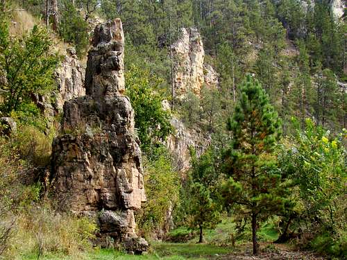
Cold Brook Canyon Rock
Canyons in the Black Hills are abundant, particularly in the warmer and more arid southern and western areas. However, many of those canyons lie on private lands, or are very remote, making them difficult to access. One beautiful canyon in the southern Black Hills, Cold Brook Canyon, has 6 to 7 miles of public access, giving hikers a good opportunity to explore a good representative sampling of a southern Black Hills canyon.
The upper reaches of the Cold Brook watershed are located in Custer County, southwest of the town of Custer. Cold Brook Canyon is joined by numerous small side canyons, most notably Antelope Canyon and Wildcat Canyon. Cold Brook joins Hot Brook at the north edge of Hot Springs, to form the Fall River. While there are many springs along the canyon, there is little or no regular stream flow in Cold Brook, unlike Hot Brook, which is fed by many thermal springs. Cold brook’s drainage area is large enough that some very significant storm runoffs can and do create hazardous conditions on the canyon floor.

Cold Brook Canyon Prairie Dogs
Cold Brook Canyon is characterized by forested slopes and limestone and sandstone walls that vary in height from less than 100 feet to over 200 feet in other places. Caves are common in the canyon, along with a variety of rock formations. While ponderosa pine is the most common tree in the region, other varieties of trees include aspen, birch, cottonwood, oak, ash and spruce. Deer are the most commonly seen large animals in the canyon. But, visitors to the canyon might also see elk, pronghorn, bison, mountain lions and coyotes. Smaller animals are abundant in the canyon, particularly prairie dogs. Foxes, bobcats, porcupines, raccoons, skunks, eagles and a variety of snakes are often seen in and around the canyon. Rattlesnakes are of particular concern, and Wind Cave National Park posts notices to that effect.
Cold Brook Lake
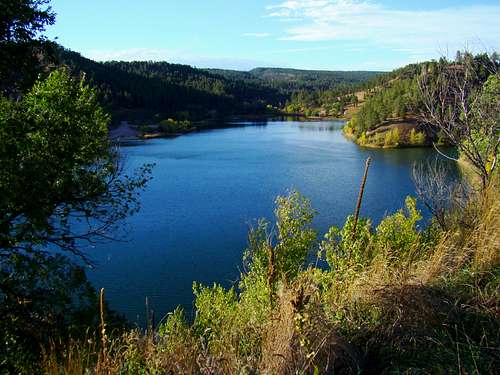
Cold Brook Lake
From the time the city of Hot Springs was formed in the late 1800’s, occasional flash floods on the Fall River were problematic. This went on for many years, until the Army Corps of Engineers built dams on the two major forks of the Fall River – Cold Brook Reservoir and Cottonwood Springs Reservoir (on the Hot Brook watershed). In 1953, a 127 foot high dam was built in Cold Brook Canyon, on the north edge of Hot Springs, creating Cold Brook Lake.
Since then, the lake has provided not only flood control for Hot Springs, but also recreational opportunities in the form of fishing, canoeing, camping and swimming. The lake has a popular beach on the southwest shoreline. In the winter, outdoor enthusiasts can ice fish, ice skate and cross country ski in the area.

Flood Debris
Considering there is no regular stream flow in Cold Brook, seeing all the water in the lake is rather amazing. However, when one sees the caches of flood debris wedged in along streambed trees in the canyon, it becomes apparent that there are some pretty substantial floods that occur following heavy rainfalls. This is also a reminder of the importance of not hiking in the canyon immediately following heavy rain in the area.
Public Exploration Routes & How to Get to Each
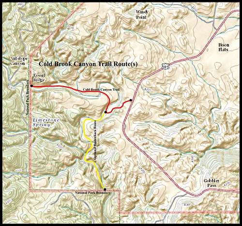 Cold Brook Canyon Trail Route + Option
Trailhead Greeting Committee
The Cold Brook Canyon Trail at Wind Cave National Park is the only defined and marked trail in Cold Brook Canyon. The Cold Brook Canyon Trailhead is 8.7 miles north of Hot Springs, along Highway 385 in Wind Cave National Park. The trailhead is 1.8 miles north of the park entrance. The trail winds down through some trees to the floor of Cold Brook Canyon, and mostly follows the canyon floor for 1.4 miles to Fossil Ridge. This is an easy hike, but be on the lookout for bison and rattlesnakes. About halfway to Fossil Ridge, there is a sizable prairie dog town about 100 yards north of the trail. When you get to Fossil Ridge, the only way to explore further up the canyon is to climb the 7-foot high fence and hike to Song Dog Road, about 200 yards west, and go to FSR682.2A (route listed below).
If you wish to explore further down the canyon, you can do an easy bushwhack on the canyon floor once you pass the location where the trail drops into the canyon. It’s about 1.5 miles south to the park boundary.
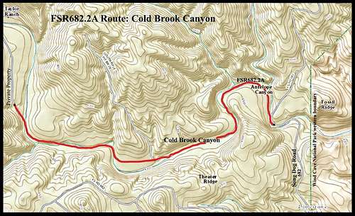 FSR692.2A Route Map

FSR692.2A Gate
FSR682.2A:To get to this forest service road from Hot Springs, travel 2 miles north of Hot Springs on highway 385 to Argyle Road. Go west-northwest on Argyle Road for 6.2 miles to Song Dog Road (Road 682). Next, travel north on Song Dog Road for 5.2 miles to Cold Brook Canyon. The forest service keeps the gate locked for FSR682.2A, so you will have to find a safe place along the side of Song Dog Road to park your vehicle. FSR682.2A runs in a generally west-northwest direction for just over 2 miles, until you come to private property. Sometimes cows graze in this area, so be prepared for that. When I went through here, there were a number of snakes on the road, but none were rattlesnakes.
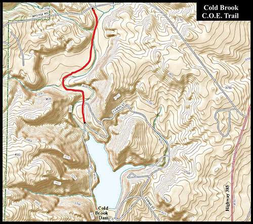 Cold Brook C.O.E. Route Map

C.O.E. Trailhead
Cold Brook Lake COE Trail: The Army Corps of Engineers built a 1-mile road from Argyle Road to the back side of the Cold Brook Lake Campground & Picnic Area. That road is locked shut and used only rarely by official vehicles. It makes a great 1-mile hike to explore the lower area of Cold Brook Canyon and reach the upper end of Cold Brook Lake. Hikers and explorers can access this trail from either the campground at the north end of the lake, or from Argyle Road. To get to Argyle Road, go about 2 miles north of Hot Springs on Highway 385, then turn west on Argyle Road and travel 1.1 miles to the trail. The old COE road/trail is barred, locked and posted with a “no vehicles” sign. There is adequate room to park by this trailhead
When To Explore

Cold Brook Canyon Butterfly
The area can be explored year-around, weather permitting. Because of flash flood potential, you will want to stay up-to-date on the weather. You can find out more by clicking here:
Cold Brook Canyon – Wind Cave National Park Weather
Hunting seasons could be a concern in the National Forest sections of Cold Brook Canyon, so be sure to wear plenty of orange if you explore during those seasons. More information about those seasons can be found by clicking here:
Black Hills Hunting Seasons.
Red Tape

Cold Brook Canyon Wall
Red tape will vary depending on what part(s) of Cold Brook Canyon you wish to explore. If the need arises, please check with the agency (see below) that manages the part(s) you wish to explore and need more information for. For the most part, you can hike the public areas year-around without any red tape. It is when people want to camp, use firearms or build campfires where potential problems could arise. Fossils are abundant in the area. Removal of fossils from public lands is illegal.
There are a few privately-owned sections of the canyon that have publicly-accessible roads through them. Where it is not posted otherwise, visitors can at least view these sections by vehicle. But hiking and exploring in these sections will require landowner permission.
Camping

Cold Brook Recreation Sign
Camping opportunities exist in different forms in Cold Brook Canyon. Camping in the National Forest portions of the canyon are regulated by Black Hills National Forest Camping Regulations. Wind Cave National Park does not permit camping along the trail, but does have its own nearby campground. Canyon visitors may also camp at Cold Brook Reservoir’s campground. For more information, please click on the desired link below:
Black Hills National Forest Camping
Wind Cave National Park Camping
Cold Brook Reservoir Camping
Information & Links for Management Agencies
Black Hills National Forest (605) 673-9200
Wind Cave National Park (605) 745-4600
Maps
Good maps for the area include the Black Hills National Forest map and the Black Hills South map published by National Geographic. Both maps can usually be purchased at area forest service offices. When you are there, you can also get a free Black Hills Motor Vehicle Use Map, that will guide you to all currently accessible forest service roads.