
-
 4975 Hits
-
 81.18% Score
-
 13 Votes
|
|
Mountain/Rock |
|---|---|
|
|
47.51691°N / 10.16101°E |
|
|
Hiking, Skiing |
|
|
Spring, Summer, Fall, Winter |
|
|
5738 ft / 1749 m |
|
|
Overview
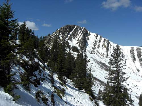
Stuiben as seen from the east
Stuiben is one of the most visited summits of Nagelfluhkette, the northernmost subarea of Allgäu Alps. The summit is likewise easily accessible from the south or the north side. Many hikers do the traverse of Stuiben via its east ridge where there are some fixed ropes to help you overcome some steep slabs, and via the western summit meadows, gently leading to the col west of Stuiben.
Stuiben is located between Sederer Stuiben to the west, more of a secondary summit to Stuiben due to its very low prominence, and Steinköpfle to the east. To the south you look down to sunny Aubach valley. Weißach valley to the north is a more shadowy part of Nagelfluhkette area.
The summit itself shows the two faces Nagelfluhkette is famous for. The south slopes, mainly meadow and wood slopes, are build up with the south dipping conglomerate slabs which form some nice rock faces near the summit, cause the steep drop to the north and some easy rock scrambling on the east ridge route.
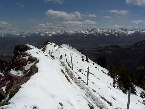
Stuiben offers a grand view on the main Allgäu summits, which are all lined up to the south and southeast, and to Bregenzer Wald region to the southwest and west. It is a year round outing for hikers, peak baggers, snow shoe tourists and ski touring.
I recommend at least a part traverse of the Nagelfluh main ridge including Stuiben summit. Its worth the trip.
Getting There
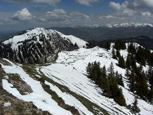
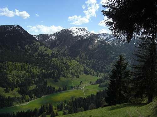
Stuiben as seen from the west
Trailhead for the northern ascent or for the traverse Mittag – Stuiben: Immenstadt / parking area Mittagbahn cableway.
Trailhead for the south ascent: Gunzesried Amtsäge, parking area
See the Nagelfluhkette area page for general advice how to get to the area.
Immenstadt can be reached on road B 19 coming from the north (Kempten) or on road number B 308, coming from the west / Austria or from the east (Bad Hindelang / Tannheim valley).
Follow Immenstadt center via B 308 and then the signposts for Mittagbahn cableway. There is a free parking area at the valley station.
For Gunzesried trailhead follow B 19 to Sonthofen exit. Follow the signposts for Gunzesried (Illerstraße and road number OA27). Cross the village of Gunzesried and proceed on Talstraße until you reach Gunzesried / Amtssäge.
There is a hiker parking area on the left at the beginning of the village.
Routes Overview
Routes Overview:
North route
Follow the forest road from the Mittagbahn parking area into Steigbach valley to Mittelbergalpe and Alpe Gund.
Use the trails from Alpe Gund leading up to the cols west or east of Stuiben summit. Follow the east ridge or the western meadows up to the summit.
 South side ascent South side ascent |
 South side ascent with Nagelfluh outcrops South side ascent with Nagelfluh outcrops |
 High on south side ascent with views into Allgäu Alps High on south side ascent with views into Allgäu Alps |
Traverse Mittag – Stuiben
Follow the ridge traverse trail from Mittag cablecar mountain station in western direction to Bärenköpfle and Steineberg. There is a short Via ferrata at the summit block of Steineberg (mainly a 20 m high ladder).
Follow the ridge crest to Steinköpfle and descend into the col between Steinköpfle and Stuiben. After a steep ascent there is a level part north of the ridge crest. The last steep ascent requires some scrambling with the help of some fixed steel ropes.
South routes
(1) Starting at the parking area of Gunzesried / Säge follow Talstraße road in western direction to one of the last building right of the road. A trail branches off there to the right, crosses Aubach creek and ascends to a road and a farm house on the south slopes above Gunzesried / Säge. Cross the road and follow the trail up into woods.
After about 150 m of altitude difference you arrive at Wiesach farm houses amidst beautifull meadows. Pass by the farm houses and follow the trail ascending the south slope above Wiesach. It zigzags up meadows and rocks, crosses Wiesach creek and ascends steeply to a broad col between Steinköpfle and Stuiben east of the latter summit.
You are now on the traverse route Mittag – Stuiben. The trail ascends steeply a bump in the ridge and traverses along the north side of the ridge more or less level until the last ascent to the summit where some rock scrambling along some steel ropes is required.
 Trail junction south side route - traverse route Trail junction south side route - traverse route |
 East ridge ascent East ridge ascent |
 East ridge scramble East ridge scramble |
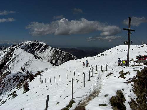
Stuiben summit
(2) A second south route, which can be combined with the first one to a nice traverse, starts at Gunzesried / Säge parking area. Follow the Autal road in western direction, crossing Autal creek, until you reach the first farm house right of the road. Follow a forest road starting at that farm house through woods until you reach a huge clearing. A trail branches off to the right at the clearing, follow this trail up to an old forest road which leads you up to the Gatteralpe. Use the trail up to the col between Buralpkopf and Sederer Stuiben. Turn right at the col and take the ridge traverse trail to Sederer Stuiben and to Stuiben.
A more direct south route starts at the above mentioned farm house. Turn right on a forest road after passing by the farm house and ascend to the upper / western end of Wiesach meadows. Turn left on a trail which ascends directly to the col between Sederer Stuiben and Stuiben. Turn right at the col and follow the ridge traverse trail shortly to Stuiben summit.
Ski routes
The direct ski routes follow mainly the northern hiking routes, starting at Mittagbahn parking area, using Steigbach valley forest road to Alpe Gund. The ascent to the summit is via the north and northwest slopes.
One of the most fascinating ski tours of Allgäu Alps is the ski traverse of Nagelfluhkette, starting at Hochgrat and traversing all summits to the east reaching finally Mittag summit. There are several interesting chutes for downhill fun. This ski traverse reaches Stuiben summit from the west, coming from Sedererstuiben and Gatteralm. The traverse then uses the north shoulder and northeast slopes down to Gundalpe to continue to Steineberg.
Red Tape & Accommodation
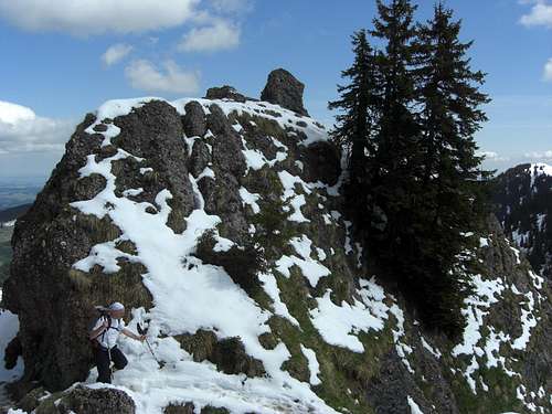
Stuiben east ridge
Red Tape
Stuiben is part of “Naturpark Nagelfluhkette”.
Naturpark Nagelfluhkette is not exactly a protected National Park.
Nevertheless there are regulations which should be followed and which are indicated at several locations with a variety of restrictions. These are mainly seasonal blocked or regulated access to defined areas. These regulations are mainly for the protection of wildlife and wildflowers.
A wildlife porotection area is located on the south side of Stuiben; it should not be enterend between December 22th and April 30th of every year.
Two small winter protection areas are located northwest of Stuiben summit and between Alpe Gund and Mittelbergalpe.
You find these areas on the Alpenverein map, indicated in the "Maps & Guid Books" section below.
Please respect them, stay on the trails and marked routes or keep out of blocked areas (mainly in winter).
Accommodation
The following towns and villages offer a great variety of accommodation:
Immenstadt
Sonthofen
Gunzesried
Ofterschwang
Gear & Mountain Condition
Ascent route via Gatteralm
Stuiben is a year round summit.
In late spring, summer and autumn it is a hiking summit which requires some short rock scrambling on the east ridge; this part can be a bit tricky with snow in spring or late autumn (northern traverse). You need normal hiking gear and should be able to scramble up or down some steep rocks with the help of fixed steel ropes.
In winter and spring you need full ski tour and avalanche gear.
Check the Bavarian avalanche bulletin here.
Current Weather:
Valley weather Immenstadt:
Mountain weather Stuiben:
Maps & Guide Books
Stuiben east ridge
Maps
Deutscher Alpenverein: Allgäuer Voralpen West, Nagelfluhkette, Hörnergruppe scale 1 : 25.000, number BY 1, 2012, with trails, ski routes and UTM grid
Landesamt für Vermessung und Geoinformation Bayern: Lindau - Naturpark Nagelfluhkette; scale 1 : 50.000, number UK50-45, 2012, with trails and UTM grid
Guide Books
Dieter Seibert: Allgäuer Alpen und Ammergauer Alpen, alpin; Bergverlag Rudolf Rother, München, 13th edition, 2013
Dieter Seibert, Heinz Groth: Allgäuer Alpen, Gebietsführer für Wanderer und Bergsteiger; Bergverlag Rudolf Rother, München, 9th edition, 1999 – actually out of stock but available as antiquarian book
Dieter Seibert: Allgäu 3, Oberstaufemn und Westallgäu; Rother Wanderführer, München, 6th edition, 2014