
|
|
Area/Range |
|---|---|
|
|
43.23197°N / 18.72014°E |
|
|
Spring, Summer, Fall, Winter |
|
|
7667 ft / 2337 m |
|
|
Overview
 North face of Volujak massif
VOLUJAK is a huge mountain massif placed on the border between the NW part of Montenegro and neighbour Republik of Srpska as a part of Bosnia and Hercegovina. Volujak range starts from Sutjeska canyon creating a left ridge coast of Soha canyon. As a unique massif long about 10 km, Volujak stretches in NW-SE direction touching with Vlasulja massif. Volujak range with its peaks represent surrounding area of Trnovaèko Jezero lake. Together with BIOC, MAGLIC, TRNOVACKI DURMITOR and VLASULJA, VOLUJAK create a beautiful mountain range, one of the most beautiful in Montenegro. That is area of untouchable devine nature, the place where the car cannot reach the Trnovacko Jezero lake. That area visit just a real lovers of nature’s beauty. Exist one place which connected the mountain ranges of Bioc, Maglic and Volujak. That is Urdeni Dolovi vasty plateau and valley.
Some mountain writers wrote that the highest peak of Volujak range is Vlasulja (2337 m) summit, but the greatest knower and devoter of Montenegro’s mountains, famous mountain writer Mr Božidar Cerovic wrote that the highest peak of Volujak is Studenac (2294 m) summit. Cerovic say that exist two names of Volujak. First name Volujak (2337 m) is the name for the highest peak of Volujak’s neigbour mountain range called Vlasulja, while the second name Volujak represent Volujak as a mountain range, placed near the Vlasulja range. Cerovic is deffinitely right, no doubt. So, if we want to be precissely, we should say that the highest peak of Volujak mountain range is Studenac (2294 m), but because of the fact that Volujak range and Vlasulja range are very close and together create one compact mountain range, we can understand the oppinions of other mountain writers which wrote that Vlasulja range with its highest peak Volujak (2337 m) is a part of Volujak mountain range. In that case, the highest peak of Volujak range is Volujak (2337 m) peak, the highest peak of Vlasulja range, on which summit is placed a border stone between Montenegro and Republik of Srpska as a part of Bosnia and Hercegovina. Volujak (2337 m) peak and Vilište (2133 m) peak, which dominate above the Stabanska Jezera lakes, represent one wholeness of Volujak massif placed on the south side of Trnovacko Jezero lake. Central part of Volujak mountain massif is Studenac (2294 m) peak.
 Volujak from Zelengora
So, the highest peaks of wider Volujak range (together with Vlasulja range) are:
- Volujak (2337 m)
- Široka Tocila (2297 m)
- Studenac (2294 m)
- Previja (2273 m)
- Badanj (2242 m)
- Lice
Volujak and its high summit plateau offer a special privilege to admire the impressive beauty of Maglic, Trnovacki Durmitor and Bioc, and of course the Trnovacko Jezero lake in the form of the heart, placed below them. On its western and southern side, Volujak is connected with Maglic and Bioc range.
Routes Overview
 On the Volujak ridge
 Ascent I
 Ascent II
Volujak massif (2294 m)
Trnovacko Jezero (1513 m) – Katun Bare (Rudinske Kolibe, 1620 m) – Greben Oštrikovac – Studenac (2294 m)
Trnovacko Jezero (1513 m) – Klanac Pletare (2040 m) – Studenac (2294 m)
Cemerno (1329 m) – Poljana (1450 m) – Klekov Do (2030 m) – Studenac (2294 m)
Vlasulja massif (2337 m)
Trnovacko Jezero (1513 m) – Boja cirque (1950 m) – Bojanska Vrata (2140 m) – Volujak (top of Mt Vlasulja, 2337 m): 3h
Presjeka katun (1826 m) – Urdeni Do (2026 m) 1h – Trzivka (2333 m) 1h – Bojanska Vrata pass (2134 m) 1:30h – Volujak peak (2237 m) 1h – Korita (1900 m) 1:30h – Ljubota plateau (1594 m) 1h – Veliko Stabansko Jezero lake (1325 m) 1h – Stabna (1050 m) 1:30h 9:30h
Stabna (1050 m) - Ljubota plateau (1600 m) – Katun pod Klekom (1800 m) – Korita (1900 m) – Štit (2100 m) – Meterize (2200 m) – Volujak (top of Mt Vlasulja, 2337 m): 5:10h
Studenac (2294 m) – Volujak (top of Mt Vlasulja, 2337 m): 2h

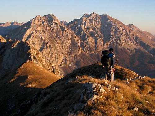
Summit View
10 km long massif of Volujak offers enjoyment in many beautiful summit views and panoramas. Most impressive of them are the view to Maglic (2388 m), Bioc (2397 m), Trnovacki Durmitor (2332 m) and to beautiful Zelengora range. Volujak summit view to Maglic, Trnovacki Durmitor, Trnovacko Jezero lake and Bioc

Getting There
 North side of Volujak above the Suha Canyon
 Volujak
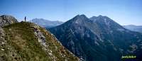 From Zelengora
From Montenegro
Podgorica - Nikšic - Plužine - Stabna - Volujak
Podgorica - Nikšic - Plužine - Mratinje - Trnovacko Jezero - Volujak
From Serbia
Belgrade (Beograd) - Loznica - Mali Zvornik - Zvornik - Višegrad - Tjentište - Prijevor - than by walk to Trnovaèko Jezero lake (shortest approach)
Belgrade (Beograd) - Ljig - Cacak - Užice - Zlatibor - Nova Varoš - Prijepolje - Pljevlja - Ðurdjevica Tara - Žabljak - Virak - Sedlo - Trsa - Plužine - Stabna - Volujak (longer approach)
Belgrade (Beograd) - Ljig - Cacak - Užice - Zlatibor - Nova Varoš - Prijepolje - Pljevlja - Ðurdjevica Tara - Žabljak - Virak - Sedlo - Trsa - Mratinje - Trnovacko Jezero - Volujak (longer approach)
From Bosnia and Hercegovina
The M-20 highway from Foca/Srbinje to Gacko, which crosses through Tjentište, is the starting point for the approach to these peaks.
It can be reached by following the M-5 highway easy out of Sarajevo.
 Volujak from Ardov Ridge on Zelengora
Camping
 Wild horses on Volujak
 Volujak above the Trnovacko Jezero
Before and after climbing of the peaks of VOLUJAK range, you can freely camping on many places around and below the mountain. First of all, you can camping near Trnovačko Jezero lake, than in the Stabna Valley near Veliko Stabansko Jezero lake and Malo Stabansko Jezero lake.
santasa - Feb 6, 2022 11:30 am - Hasn't voted
Geography and terminologyIf the range is shared by Bosnia-Herzegovina and Montenegro, if the number of Volujak's highest peaks (including the highest) are the very border points between two countries, if Republika Srpska is "part" or administrative entity of Bosnia and Herzegovina, why is, then, this massif tagged as "Montenegro, Europe", why is neighboring country to Montenegro R.Srpska, instead of Bosnia and Herzegovina, and, additionally, isn't "Srbinje" name abolished and its old (historic) name Foča only proper name for the town ?! Can we expect genuine take on these issues, and eventual correction?