The Most Texas Part of Texas
Burdened with a Southwest frequent flier ticket, I couldn’t bear the thought of not using it right away. My solution was to take a trip to the desert country of West Texas, coined by one author as “the most Texan part of Texas.”
Just about every outdoor hiker/backpacker – even the Texans I’ve talked to – knows about Big Bend but invariably has not been there because it’s too far from everywhere in Western civilization. Undaunted by such claims of legendary remoteness, I decided that I was just the man for the job.
It had been 12 long years since I left the Lone Star state, leaving behind Lone Star beer, Aggieland and the Republic of Texas for the sunny skies and liberal ways of my native California.
The nation’s most populated states, Texas and California, are perhaps the two most diverse of the United States in both culture and ecosystem. This is not surprising, as both Texas and California each enjoyed the distinguished status as republics prior to statehood. Some from both states would no doubt argue that it should have remained that way.
We Californians often find frustration with those from elsewhere who think of California as little more than sunny, sandy beaches with Hollywood, Disneyland and the debauchery of San Francisco thrown in for good measure. Texans feel much the same, as their state is often mythologized as little more than humidity, oil wells, cowboy hats, and a cult of high school football fanatics. Of course, there’s a lot of truth to that.
But there is so much more - the music scene and limestone topography of the Hill Country, the rich waters and sandy beaches of the Gulf Coast, the thick, wet green forests of East Texas, the grasslands of the Panhandle, the thousands of proud little towns with stately courthouses and Dairy Queens, the Dallas skyline, the flat plains near Lubbock that look so much like my home as a kid in California’s Central Valley.
One region of the Lone Star state that particularly evokes hopelessness, despair, and sweltering heat is the desert country of West Texas. The only experience of many people with this part of Texas is the god-awful, wind-swept, endless drive on the I-10 from the Hill Country to El Paso. However, what many don’t know is that this part of Texas contains some of the most beautiful and biologically rich desert country anywhere in the world, the Chihuahuan desert.
Fall Frolic in the Desert
My early November visit was timed to take advantage of the fall colors of McKittrick Canyon, claimed by many to be the most beautiful spot in Texas. It’s hard to argue with that, as I found out firsthand.
Flying into El Paso about 11:30, I hopped in the rental car and after a mini-mart provisions stop I drove the 100 plus miles of vast West Texas nothing – and I mean nothing, not a gas station, 7-11, or anything else - to Guadalupe Mountains headquarters.
I get out of the car, nearly knocked down by the ferocious wind. Oh yes, that’s right, the wind still blows like hell all the time in West Texas, just like when I was there 12 years ago. It’s comforting to know that not everything has changed in age of global warming.
No tent camping tonight – made me wish I upgraded from my economy size car.
After a cramped and ugly night, the wind still is howling – can’t even wear my Aggie hat to show my Texas A & M spirit. I abandon thoughts of the hike of Guadalupe Peak and instead decide to go check out McKittrick Canyon and the rumors of fall color.
Sauntering down the McKittrick trail, the ever worsening wind showers sand into my eyes. Lots of people are around though, as the Texas color show is winding up for the season. Despite the company, the cyclonic wind, and the annoying reminders to stay on the trail, I quickly encounter a dazzling array of fall colors, yellows, oranges, reds, greens – you name it. The ubiquitous tan-brown of barren, thirsty deserts for hundreds of miles in each direction has been left behind in this oasis.
Unfortunately, the popularity of the place has rendered the creek itself off-limits to exploration, putting a serious crimp in my photo plans. The seasonal rangers prowl for wayward tourists like black bears rummaging about a High Sierra camp. The $5 trail fees doesn’t help. I decide to get my money’s worth, so I leave them all behind and hike up the trail to McKittrick Ridge to get a better view.
I keep hiking ever higher on the ever more vertical trail, just for the joy of seeing what was around the next bend. The views become ever more spectacular, marked by endlessly deep canyons, big walls alive with the sway of red, orange, yellow, and green trees, and the rolling hills of the high Guadalupe mountains perched almost a mile above the West Texas desert plains. Not what I expected and definitely not to be missed.
As I hike, my thoughts wander to the destination I really had in mind – Big Bend. Getting out of the punishing and relentless cold Guadalupe wind will also be a bonus. Being there reminded me of a conversation with a hotel clerk in Lee Vining, who told me that before she moved there she used to like the wind. I suspect many West Texans feel the same.
Many wind-beaten hours later, after finally making it to the high camp, I hiked back down into the canyon and the parking lot, back to civilization. I must admit, though, that seeing all the A & M apparel on kids and adults alike made me feel among friends. Like a small part of me never left.
Big Bend Bound
The sun sets as I drive the long 400 mile drive to the Chisos Mountains campground, the endless, deserted West Texas plains stretching in every direction.
After fueling up with pizza in the dumpy wide stop on I-10 they call Van Horn, I drive on south. After a few hours I get stopped by a genuine small town Texas cop who stops me for going 70 in a 65 zone. Correction – the speed limit was 75 with 65 at night. Definitely not in California anymore! The cop is nice though and lets me off with a warning. I drive on and on through the empty countryside. I go through the town of Alpine - certainly a funny name for this part of the country. It would probably confuse a German or Austrian.
On and on I follow the asphalt ribbon. A million stars are in the sky. After what seems like forever the plains of the Llano Estacado are finally left behind, replaced by the dark serrated skyline of the Chisos Mountains. Mountains of Texas! The arrow-straight roads give way to the 10 percent grade and wildly snaking pavement – like the Sierra highways of home. The home of the mountain lions, black bears, the javelina, and more than 300 species of bird.
The Chisos Range, the true centerpiece of Big Bend National Park, are real mountains – underappreciated for sure. Steep walls and jagged peaks, in contrast to the more rounded Guadalupe Range, mark the surroundings. Many are probably waiting for their first ascent. Rotten rock and blast furnace heat keep climbing to a minimum though. Thorny brush choked approaches don’t help either.
To best experience my one day in the Chisos I decided on a well trod, yet representative path. I selected the South Rim trail, perhaps the most famous trail in the park, to be topped off, by an Emory Peak summit ramble. In Backpacker and other outdoor periodicals, the South Rim trail is hyped. We’ll see.
The desert air is chilly. Like usual, though, it quickly gets hot on this cloudless day, like usual in the desert. God it must be hot in the summer. I go upward, switchbacking around and through the diseased towers they call “The Pinnacles.” Below me lays a panoramic, sun kissed Lone Star vista, the mountain fortress of the Chisos Basin lying 2,000 feet below. The peaks of the Chisos sky island surround me in every direction.
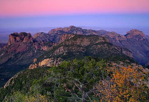
Eventually I leave the thick brushy forest and reach the southwest rim. It is here I see what all the fuss is about. The Elephant Tusk juts skyward in the foreground. Rolling desert ranges endlessly stretching far into Mexico, for probably more than a hundred miles despite the cloudless hazy day.
By the trail, wildflowers flourish and a new tree species is encountered for what seems like every few hundred yards. The trail continues along the south rim, then the southeast rim. The peaks and walls of the Sierra Del Carmen range, lying just across the Rio Bravo, dominate the southeast skyline. Rugged, remote, dry, and rotten, many of these peaks probably await a first ascent.
The short November day speeds forward. Hours that go slow at work speed up orders of magnitude once one is on the hiking trail.
Time to head to Emory. I decide to go back a different way and select the shade rich Boot Canyon trail. All of a sudden, the bone-dry range is replaced by a watery oasis, the scrubby desert giving way to the rich, multi-colored maple leaves of fall and pools of clear water dotting the rocky streambed of the canyon bottom.
Sunset on Emory
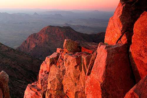
Climbing out of this paradise, I reach the Emory trailhead. Winding through thick scrub, the trail stair-steps upward for 1,000 vertical feet or so. Near the top, a rocky outcropping blocks progress. Easily solved, the summit is reached after a few minutes of lazy scrambling along the rocks. Lots of company here- more social climbing than mountaineering here.
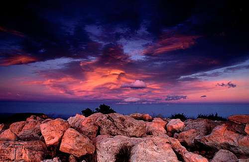
It is late afternoon, but sunset is hours away. I linger, planning to capture the sunset on film – well at least on the digital camera’s computer. The next few hours are spent trying to discover what little shade exists on the mountaintop. Eventually, the sun drops lower in the sky. At the same time, the hazy desert hills on the horizon start to come into focus, the harsh light of the day having been shed. I snap shots in every direction. The top of the Chisos is one hell of a vantage point. Darkness finally arrives – time to head back to camp via headlamp.
West Texas Wandering
The next morning, the winds howl. Deciding on a non-mountain, relaxation day, I drive out to Rio Grande Village. First stop is Bolquillas Canyon for sunrise. The sign in the parking lot warns of frequent auto break-ins.
A short hike later, I reach the Rio Bravo, the ocotillo and brown gravel and dirt replaced by the giant reed and the green grass of the riverbank. Wind is still howling. Horses are grazing here – weird. Later I report to the ranger, who tells me the horses probably come from the Mexican side and cross the river. Why? Because the grass is greener on the other side.
Nervously I consider whether my rental car is being broken into so I return to the car. The sun is rising in the wrong part of the sky anyway. South has become the new east. My sense of direction is skewed as this is the location of the “Big Bend.” Driving back, the little, desperately poor hamlet of Bolquillas Del Carmen passes through view, perched on a bluff across the river. The 150 mile drive on a dirt road from the Mexican side makes it a rarely visited destination. Illegal to cross here via boat.
A while later, I arrive at the Rio Grande Village. The wind, swept bare brown desert is replaced by manicured green lawns and cottonwood trees, along with a flotilla of motor homes and tent campers. Still, it is peaceful and quiet. Back home in the Sierra Nevada, the trees are bare. Here, in the hot desert, the cottonwoods are barely starting to turn yellow. Maybe the long growing season is the reason why they are so tall and majestic here.
A trip to the visitor center makes a hike to the hot springs sound nice. It might just be the only hot spring in Texas. I take the path less traveled to the hot spring, opting for an eight-mile walk in the desert. Of course, the canteen doesn’t have enough water and it is hot – maybe 90 or so. Getting dehydrated on a day hike in November seems ridiculous so I just ignore it and keep walking.
Finally, a well-earned soak in the hot spring. Right next to the river! A once thriving resort is gone, its only remnant a concrete foundation capturing hot water. 105 degrees or so is perfect, especially after two days of hard hiking. Visitors come by and we engage in pleasant conversation. Most of them don’t even stick a toe in the water. Perplexing, as why would one go to the trouble of visiting a hot spring like this one without taking a soak.
The rest of the day is spent exploring the vast park, mostly by car, ending up with a lazy afternoon spent at the mouth of the Santa Elena Canyon along the north bank of the Rio Bravo.
Eventually, the short day again grows dark. Looking at the guidebook, the adjacent towns of Terlingua and Study Butte are selected for dinner and lodging. Both towns apparently consist of a single highway intersection. A small Mexican restaurant is the only place open.
Dinner is exciting, as the fajitas (OK) are accompanied by an evening show consisting of a trailer across the road and bursting into flames across the road. The cops and firefighters – where did they come from? – descend quickly on the scene. It looks like yet another meth lab has self-immolated. Not surprising in poor rural Texas.
Heading Home
The last day of the trip has sadly arrived. All good things must end. I decide to end my Lone Star bonanza with a hike to the top of the state of Texas on the Guadalupe Peak trail. First, though, there is a long way to go on the road.The winding asphalt road parallels the Rio Bravo. After passing through the Sedona-esque resort town of Lajitas, I enter the very lonely Big Bend Ranch State Park. No facilities, no nothing, only a grand unspoiled swath of the Chihuahuan desert.
After 50 or so twisty, turny miles, ramshackle buildings pop up on both sides of the river. A casual observer would wonder why so many would wish to cross the border as both sides look about the same. Going through the town of Presidio, one can only wonder what the point of crossing over to Los Estados Unidos even is.
Turning northward, the vast West Texas plains stretch out before me on the highway. Odometer set at 64 to avoid more troubles with the Highway Patrol. Miles pass and nothing. More miles, more nothing, except for a few abandoned buildings and the odd sight of camels grazing on the brown prairie grass. The failure of the Texas Legislature to ban exotic animals does have an occasional benefit.
Hours later, I cruise into Marfa and have a burger at the Dairy Queen. When in Texas, do as the Texans do. The town seems empty and devoid of life, except for painted signs all across town wishing the girls’ volleyball team good fortune at state. The town does seem like it has seen better days. Perhaps it will eventually become a ghost town, like so many towns have become out on the hot, dry, wind scoured plains of west Texas.
More driving. Eventually I arrive back at the Guadalupe trailhead about 2:00 p.m or so, where I was four days ago. The wind is still cold and blowing like hell. Damn, this place is windy.
The Top of Texas
This time, though, the gale will not derail the journey. Finally time to head to the top of the Lone Star state.
The scrubby desert vegetation quickly gives way to scattered groups of pines sprouting out of the bone white “rock” of the Permian Reef. Fossilized algae and sponges probably don’t make for the best multi-pitch climbing. The cold wind blows harder as I hike upward.
The pine forests eventually give way to the grasses and brush of the uppermost rocks of the peak. With the escape from the pines come endless views of the West Texas and eastern New Mexico plains, the rolling, relatively gentle topography of the Guadulupes hovering above yellow sea of the desert over 4,000 feet below. A notable exception to the rolling hills is the precipitous face of the El Capitan, which is located just to the south of the trail.
The apex of the Guadalupe Range and the Lone Star State is awash in a tempest of wind, clouds streaming across the blue sky. I take cover beneath the strange, small metal pyramid that marks the summit plateau, feeling stupid for leaving a perfectly good down jacket back in the car.
Despite the cold wind I enjoy the wide, sweeping views of the desert while waiting for sunset, the occasional road, the salt flats, the low hills of the desert stretching beneath me along with the jaw dropping view of El Capitan at my feet. After a few hours, the sunset finally comes. I take my hiker hat off and put on my photographer hat for a while. Mother Nature does not disappoint, at least today.
Darkness inevitably comes. All that’s left of my mini-vacation now is a hike back to the car and an uncomfortable night in the El Paso airport. I am certain I will be back again soon to wander the most Texas part of Texas.


Comments
Post a Comment