
-
 20364 Hits
-
 81.18% Score
-
 13 Votes
|
|
Route |
|---|---|
|
|
41.38299°N / 120.21755°W |
|
|
Hiking, Scrambling |
|
|
Summer, Fall |
|
|
Overview
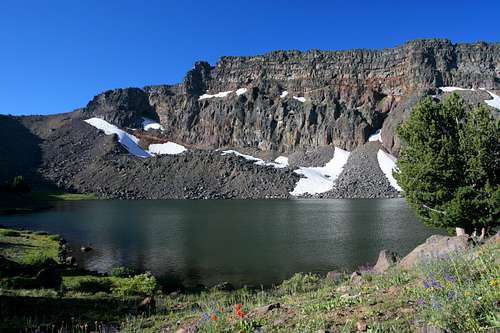
Warren Peak and Patterson Lake
The Warner Mountains offer some of the remotest, most spectacular scenery in California. The range offers gorgeous scenery very different from anything else found in California, more closely resemblance to ranges in Colorado or parts of Nevada. The prospect of unusual terrain, soaring peaks, plunging cliffs, crashing waterfalls, sparkling lakes and pervasive aspens all devoid of other visitors is an alluring proposition…if you are willing to make the journey to the remotest part of the state.
The best way to experience all the Warners have to offer is to combine the Warner Summit trail with Squaw Peak and Owl Creek Trails, forming an epic, 45-mile loop. However, if one does not have time to make the entire journey, a trip along the Summit Trail to Patterson Lake and Warren Peak make an excellent introduction to the range. A side trip up Squaw Peak can also be made from this route. Furthermore, combining the Summit Trail to Patterson Lake with the Squaw Peak Trail can make a great, shorter backpacking trip.
Route Description
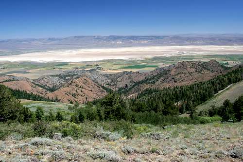
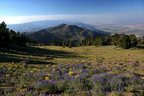
Surprise Valley from the Summit Trail
The Summit Trail begins at Pepperdine Camp. The elevation is 6,830. It is 6 miles to Patterson Lake and another 0.75 miles to the summit of Warren Peak. The trail climbs through a forest of mixed pine and fur before entering a large clearing. The trail will remain open for the rest of the journey, passing through isolated groves periodically. After 0.25 miles, the Summit Trail passes a sign marking the boundary of the South Warner Wilderness.
From the wilderness boundary the route continues to climb, passing strange rock formations. The formations are the first indication that Warners are volcanic in origin. The twisted and eroded rock is composed of tufa, hardened volcanic ash that is easily eroded by wind and water. A mile past the wilderness boundary the trail begins to climb more steeply, up a broad grassy slope. Views of Squaw Peak to the south and the Modoc Plateau to the west are excellent.
Another 0.50 miles deposits one on the crest of the Warner Mountains for the first time. Views in all directions are glorious. After hiking 0.25 miles along the crest one reaches the junction with the Squaw Peak Trail. The trail does not actually climb Squaw Peak, instead it rounds the eastern flanks of the mountain, eventually entering the Cottonwood Creek drainage and connecting to the Owl Creek Trail.
A steep connector trail links the Squaw Peak Trail to the Summit Trail. If one desired to make a backpacking loop, this would be the point to deviate from the Summit Trail. An excellent campsite in a meadow at the base of a waterfall on Cottonwood Creek provides and excellent campground prior to making the climb to Patterson Lake.
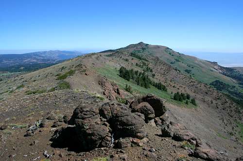
Squaw Peak from the Summit Trail
Continuing south on the Summit Trail, the route travels the undulating crest as it approaches Squaw Peak. A mile past the junction with the Squaw Peak Trail, the Summit Trail climbs a low ridge that runs to the summit of Squaw Peak. If one wants to summit the mountain, this is the place to do it. A large pile of rocks is visible just below the summit. Angle towards this as one climbs and the scramble up the rock pile to the top for excellent 360-degree views. It is a 450 foot climb from the trail to the summit.
The route to the top of Squaw Peak begins 3 miles from the trailhead. From here, the Summit Trail continues along the crest of the Warner Mountains. Views continue to be excellent, especially to the east, looking into the Surprise Valley and to the west, where Mt. Shasta looms on the horizon. After another 2 miles, the trail reaches the broad base of Warren Peak, although this is difficult to discern from the trail. Small Cottonwood Lake appears at the base of tall cliffs. While not as large, deep, or beautiful as Patterson Lake, it is still a lovely spot that is a good place to rest before making the final push to Warren Peak.
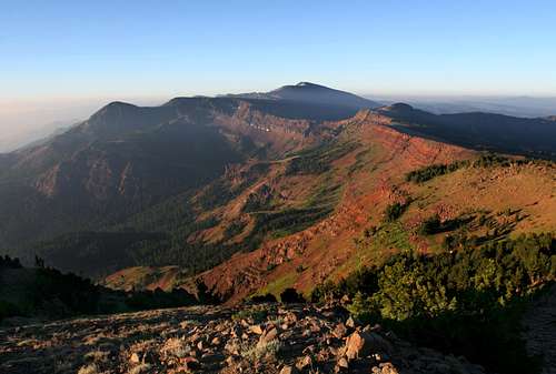
Warner Mountains from Patterson Saddle
One more mile brings one to the shores of Patterson Lake at 9,025 feet. The lake is vast, nearly 0.25 miles across with cliffs rising out of the lake, soaring 700 feet above. The summit of Warren Peak is the apex of the highest point along the top of the cliffs, just to the right of a round rock pinnacle.
The Summit Trail continues along the lake, crossing over the small outlet stream. It begins climbing again, reaching Patterson Saddle at 9,365 feet. The views to the south are astonishing. Eagle Peak, the highest point in the Warner Mountains can be seen floating in the distance, high above the Owl Creek drainage.
The Warner crest drops away in a series of scalloping cliffs extending to the south. Dusenberry Peak is visible at the southern end of the drainage. Continue a few hundred yards along the Summit Trail before turning to the west.
There is no trail to the summit of Warren Peak, but it is not difficult to pick a route through the stunted lodgepole pines. Try to stay level for a hundred yards or more before starting to climb up the steep, loose slope. Beginning to climb too early will deposit one on a shoulder about 100 feet below the actual summit. When descending Warren Peak, this makes a handy off-trail route to climb down to Patterson Lake. A band of small cliffs extend from below the summit to the west. The route to the summit angles above these cliffs, which can be avoided if one stays on or just below the ridge leading to the summit.
Getting There
Squaw Peak just below from Patterson Saddle
From the junction of Highway 299 and Highway 395 in Alturas, head south on Highway 395. At the south end of downtown, turn left (east) on County Road 56, which is also named E. McDowell. The road winds for several miles, climbing up to a levee and passing a reservation casino before dropping into a shallow canyon. Views of the west slope of the Warners are excellent. Eagle, Warren and Squaw Peaks are prominently visible.
Eventually, the road enters Modoc National Forest and becomes Forest Road 31. Although the pavement ends the road is in excellent condition and is passable by sedans. After climbing a few more miles through the forest turn right onto Forest Road 42N79. Look for signs marking Pepperdine Camp. Do not turn left to go to the horse camp but continue straight a short distance to the parking lot at the marked trailhead.
Maps
