
-
 7894 Hits
-
 75.81% Score
-
 6 Votes
|
|
Route |
|---|---|
|
|
41.40456°N / 120.21538°W |
|
|
Hiking |
|
|
Summer, Fall |
|
|
Overview
Squaw Peak and Cottonwood Creek
The Squaw Peak Trail is one of the most scenic trails in Northern California. It has spectacular scenery nearly every step of its entire length and accesses some of the prettiest sections of the Warner Mountains, one of California's remotest mountain ranges. Ironically, the Squaw Peak Trail does not actually climb its namesake mountain. Instead, it travels around three of the four sides of the peak, passing from the north side to the south side. Beyond Squaw Peak, the Squaw Peak Trail climbs up the terraced flanks of the Warner Mountains before emerging on the shores of Patterson Lake, one of the most the most fantastic destinations in the northern part of California. Along the way, the trail passes through several verdant meadows and along numerous creeks tumbling down the Warner Mountain's remarkably rugged eastern escarpment. The trail beings and ends at junctions on the Warner Summit Trail, so it can be used to form a striking loop, covering some of the most attractive parts of the Warner Mountains. The Squaw Peak Trail is also one of the three trails, along with the Warner Summit Trail and the Owl Creek Trail that combine to form the epic circuit around the South Warner Wilderness.
Route Description
The Squaw Peak Trail is accessed from the north via the Warner Summit Trail.
The initial section of the Squaw Peak Trail seen from Squaw Peak
Warner Summit Trail to Squaw Peak Trail Junction
The Summit Trail begins at Pepperdine Camp. The elevation is 6,830. It is 6 miles to Patterson Lake and another 0.75 miles to the summit of Warren Peak. The trail climbs through a forest of mixed pine and fur before entering a large clearing. The trail will remain open for the rest of the journey, passing through isolated groves periodically. After 0.25 miles, the Summit Trail passes a sign marking the boundary of the South Warner Wilderness.
From the wilderness boundary the route continues to climb, passing strange rock formations. The formations are the first indication that Warners are volcanic in origin. The twisted and eroded rock is composed of tufa, hardened volcanic ash that is easily eroded by wind and water. A mile past the wilderness boundary the trail begins to climb more steeply, up a broad grassy slope. Views of Squaw Peak to the south and the Modoc Plateau to the west are excellent. An additional 0.50 miles deposits one on the crest of the Warner Mountains for the first time. Views in all directions are glorious. After hiking 0.25 miles along the crest one reaches the junction with the Squaw Peak Trail. The Summit Trail continues to climb to the south.
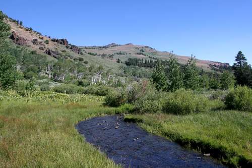
Cottonwood Creek cascades down into Cottonwood Meadow
Squaw Peak Trail to Cottonwood Meadow
Once on the Squaw Peak Trail proper, the path drops below the crest of the Warner Mountains as it continues south. After passing some springs and an increasingly deep canyon, the trail briefly enters a thick group of pine and aspen. On the far side of the small wood, the trail again enters open terrain. Below the route is a broad flat bench occupied by a very large meadow. The meadow is the source of Milk Creek, which cascades down into the Surprise Valley far below. The summit of Squaw Peak is visible high above. The route rounds the southern fringe of the meadow before making a broad arc around the eastern flank of Squaw Peak. The terrain is grassy and the views are superb throughout. Once the trail has reached the south side of the mountain, it begins to drop quickly. After 0.5 miles, the path reaches a switchback, turning sharply to the east. As good as the views have been, they are now an order of magnitude greater. The cliffs of Warren Peak and “Cottonwood Butte”, with Cottonwood Creek cascade down them are staggering. Cottonwood Meadow is nestled into a small basin at the foot of these giants and the creek snakes its way through the lush grass. Another 0.5 miles results in another switchback, the trail now heading west. Soon the route begins to drop at a faster rate, passing the intersection with the Owl Creek Trail as it makes the final descent into Cottonwood Meadow. The Owl Creek Trail diverges from the Squaw Peak Trail on the far side of Cottonwood Meadow.

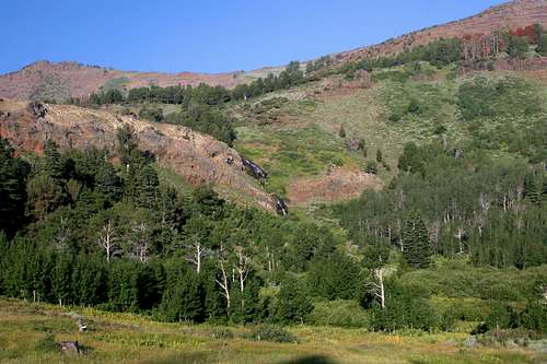
Squaw Peak and "Cottonwood Butte" from high on the Squaw Peak Trail
Squaw Peak Trail to Patterson Lake
Cottonwood Meadow makes an excellent campsite. The cliffs and peaks, the waterfall, creek and meadow are all perfectly situated to construct a premier place to spend the night. To continue on the Squaw Peak Trail, one must cross Cottonwood Creek and pass through more meadow on the far side, reaching the junction where the Owl Creek Trail continues on to the south. “Cottonwood Butte” looms high above the junction. The Squaw Peak Trail turns to the west and begins to switchback up the lower flanks of the butte. After 0.45 miles the trail reaches a meadow filled valley. Proceeding south, it passes along the back side of “Cottonwood Butte”. While the peak can be summited from here, easier and more open route is possible if one continues along the valley and then climbs another set of switchbacks, a distance of about 1 mile. At this point, the trail has reached the southern slope of “Cottonwood Butte”. Reaching the summit is a simple matter of hiking cross-country across the summit plateau to the precipice on the east end of the butte.
Resuming the trail, it proceeds south another 0.5 miles before crossing Patterson Creek. Beyond the crossing, the trail skirts an unnamed and sometimes dry lake. Once past the lake, the Squaw Peak Trail begins its final push up the cliffs below Patterson Lake. It crosses Patterson Creek again and then begins switchbacking in earnest through flower filled meadows. It finally intersects the Summit Trail 0.75 miles from the dry lake. Once on the Summit Trail, it is 0.2 miles to the shore of Patterson Lake, easily the most spectacular spot in the Warner Mountains.
Map

Getting There

Squaw Peak seen from the junction of the Summit Trail and the Squaw Peak Trail
The following directions are for the Warner Summit Trail trailhead, which is where one must begin to reach the Squaw Peak Trail.
From the junction of Highway 299 and Highway 395 in Alturas, head south on Highway 395. At the south end of downtown, turn left (east) on County Road 56, which is also named E. McDowell. The road winds for several miles, climbing up to a levee and passing a reservation casino before dropping into a shallow canyon. Views of the west slope of the Warners are excellent. Eagle, Warren and Squaw Peaks are prominently visible. Eventually the road enters Modoc National Forest and becomes Forest Road 31. Although the pavement ends the road is in excellent condition and is passable by sedans. After climbing a few more miles through the forest turn right onto Forest Road 42N79. Look for signs marking Pepperdine Camp. Do not turn left to go to the horse camp but continue straight a short distance to the parking lot at the marked trailhead.