-
 6192 Hits
-
 75.81% Score
-
 6 Votes
|
|
Route |
|---|---|
|
|
41.93498°N / 120.22545°W |
|
|
Hiking |
|
|
Spring, Summer, Fall |
|
|
Overview
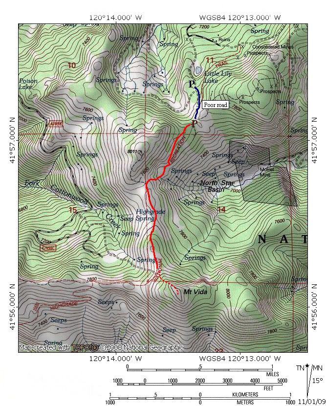
The Highgrade National Recreation Trail follows the route of an old jeep road along a high ridge in the northern Warner Mountains. It passes a few hundred feet below the summit of Mount Vida, one of the highest points in the northern part of the range. The trail initially passes through forest before climbing to an open ridge with outstanding views in all directions. The trail has the distinction of being the northeastern most maintained route in California. The roundtrip from the saddle to summit and back is an easy 3.6 miles.
While this is a somewhat diminutive route to be contained in its own route page, it is a contribution to the larger goal of having a complete set of pages for all the trails in the Warner Mountains.
Route Description
Although the official trailhead is 0.25 miles further up the road from the parking area, the Highgrade Trail essentially begins at the saddle above the steep, potentially hazardous section of the access road. For those parking below the steep, muddy section, the road levels off at the saddle and begins to round the southern edge of Point 8,011. While initially passing through forest, the trail, which is really an abandoned jeep road, enters into large patch of corn lilies. Views begin to open up, with views of Mount Vida to the south and the large bulk of flat topped Mount Bidwell to the east.
Soon the level trail begins to decline, gradually at first and then precipitously. The forest is left behind and grass and sage cover the mountain predominantly. The trail, which was engineered for 4x4’s and not people drops and climbs at grades that seem unreasonable for foot traffic. The reason for the routing is a large band of cliffs at the top of the North Star Basin headwall. As one descends around the cliffs, views of the basin continue to open up. Mount Vida remains a constant presence to the south. After descending, the trail immediately climbs to the saddle between Point 8,011 and Mount Vida. This is the steepest part of the entire route. If the trail is muddy, stay off of it and try to step on the rocks either side of the route.
Once one reaches the saddle, a host of views confronts the hiker. On the western horizon lie Mount Shasta and Mount McLoughlin. Other visible landmarks include the Mountain Lakes Wilderness in Oregon and the Medicine Lake Highlands in California. Goose Lake is an immense presence nearly 3,000 feet below the saddle. The eastern edge of the saddle provides the best views of the interior of North Star Basin as well as of Mount Bidwell. It is another 0.6 miles to the base of Mount Vida from this point.
The Highgrade Trail does not actually reach the summit of Mount Vida. Instead, in continues south, routed around the base of the summit. It eventually intersects another Forest Service Road. To reach the summit of Mount Vida, simply turn left off the trail and pick one’s way through the stunted lodgepole and white pine to the summit. From the route, a rocky outcrops forms a bit a false summit, the actual highpoint is located about 50 yards further south. Views from the summit encompass all previously described from the saddle but also extend into Nevada and along the southern spine of the Warner Mountains, as well as down the axis of Surprise Valley. To the north looms Crane Mountain and the Drake’s Peak area.
Map


