Stats
| Peaks climbed: | Wasatch Benchmark (13156') , NW Wasatch (13039'), Tokewanna (13165') |
| Low Point: | 9280' |
| High Point: | Tokewanna summit at 13165' |
| Total Elevation Gain: | 5500' |
| Total Miles: | 21.1 |
| Trail Miles: | 13.2 |
| Off Trail Miles: | 7.9 |
| Time: | 14 hours 45 minutes |
The Trip
![Wasatch Benchmark]() Wasatch Benchmark (13156')
Wasatch Benchmark (13156')![NW Wasatch]() NW Wasatch (13039')
NW Wasatch (13039')![Tokewanna Peak]() Tokewanna Peak (13165')
Tokewanna Peak (13165'),
NW Wasatch, and
Tokewanna Peak are three Utah 13000 footers that I had wanted to climb together for years but never got around to. One big deterrent is that I hate stream crossings and it sounded like there would be quite a few. I was running out of other 13000 footers and the time had finally come.
The three peaks are connected by a 2.5 mile long ridge with lots of little ups and downs in between. It looked pretty interesting, judging from its narrowness on a topo map. I had previously skied to the summit of Tokewanna from the very gentle northeast ridge and had gotten a glimpse of the ridge beyond leading to NW Wasatch and Wasatch. It looked very rugged indeed. I was able to enlist
Moogie737 to accompany me as he has an interest in climbing Utah's 13000 footers as well.
The trail starts at the end of a 20+ mile dirt road. On the Wyoming side, it starts out like a superhighway. There is no mistaking when you get to Utah because the instant it crosses the border it immediately becomes rough and rocky, but still suitable for all cars. There is a nice, free campground with about 10 sites at the trailhead, but there is no water.
I arrived the evening before about 8pm, early enough to scope things out in the daylight. The place was deserted. On a Monday night, there were 3 cars in the parking lot and all of the campsites were empty. Moogie737 was to meet me the next morning.
I followed the trail a short distance down to the creek and observed the sturdy bridge spanning a good sized stream. The water was still flowing pretty strong at the end of July. Hopefully it wouldn't look so bad upstream.
The next morning I got ready to go but at 5:30am there was no sign of Moogie. Worried that he had perhaps stopped at a different trailhead, I drove back on the bumpy road to meet him. I saw no headlights, only desolate blackness. After what seemed like an eternity I finally saw his headlights in the distance and turned around to lead him to the parking area.
Our plan was to follow the East Fork Black Fork Trail 8.2 miles until east of Wasatch, ascend Wasatch's very steep east ridge, traverse north over NW Wasatch to Tokewanna, and then descend Tokewanna's northeast slope back to the trail. As do virtually all hikes to Uinta peaks, this hike would have a long flat approach followed by a very steep climb in which almost all of the elevation is gained at once. While on the trail, less than 1600' is gained in over 8 miles. At its steepest, the ridge gains 800' in a quarter mile. The total mileage would be just over 21 miles round trip with a total elevation gain of 5500'.
We got underway about 6am. The trail is easy to follow most of the time. However, it goes through several marshy meadows in which the tread disappears. But by going straight across we were always able to pick it up again. In these areas, the grass is quite high, the water is an inch or so deep, and the mud tries to suck your boots off.
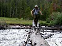
The stream crossings turned out not to be so bad. There was one at the beginning on a nice solid bridge, two on fallen logs, one that involved a big step from an unstable base, and two that were on scored split logs. There was also one bad one that required wading in knee deep ice cold water with slippery rocks under foot. There are two crossings shown on the map, at about 9600' and 9700', that do not actually occur .
One of the log crossings is on a log so gigantic that it is even visible in Google Earth. I wonder if it just happened to fortuitously hook on to the remaining half of a dilapidated bridge or if there is any way human effort came into play. It was quite a big tree and it hard to imagine it being moved by people but it is quite a coincidence that it ended up where it did.
The log crossings were difficult first thing in the morning because they were wet and slippery. On the way back the logs were dry and the crossings were much easier. I'd hate to see what they'd be like after a frost.
Here are pictures of some of the creek crossings.
![Gigantic log]() The gigantic log on the way back The gigantic log on the way back
| ![East Fork Blacks Fork]() Knee deep, cold, and slippery Knee deep, cold, and slippery
| ![East Fork Blacks Fork Tributary]() Big step off of a slippery rock Big step off of a slippery rock
|
As we neared the east end of Wasatch Benchmark, the trail fortuitously did not follow the path shown on the map but took almost the exact route I planned to bushwhack until we were almost due east of the summit. We were spared almost 600 vertical feet of plowing through trees. When we finally left the trail at about 10:15, the terrain was very open and easy to navigate. The east ridge of Wasatch loomed ahead. At the end of July, we found a small stream right at the base of the ridge.
![Point 12268]() The east ridge of Wasatch ascends steeply to point 12268 The east ridge of Wasatch ascends steeply to point 12268
|
![East ridge of Wasatch Benchmark]() Getting close to point 12268 Getting close to point 12268
|
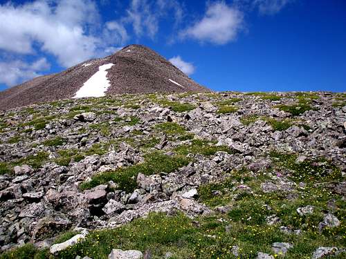
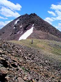
From a distance it looked like we'd be clawing our way up, but again fortuitously, our route up consisted of nice stable medium sized boulders and it wasn't so bad. It was energy intensive but not difficult. Once point 12268 is reached about half way up, the ridge becomes considerably less steep. It took about 2 hours to get to the summit from where we left the trail.
![East ridge of Wasatch Benchmark]() The gentle upper half of the ridge The gentle upper half of the ridge
|
![East ridge of Wasatch Benchmark]() Looking back Looking back
|
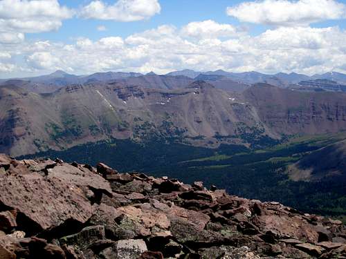
As we climbed, a great view of
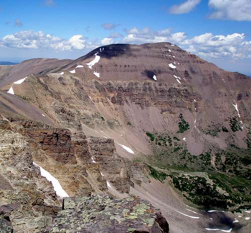
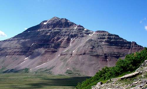
Mount Lovenia was to our left and an equally great view of Tokewanna Peak was to our right. In a few hours we'd be standing on top of Tokewanna, but Mount Lovenia would have to wait for another trip.
![Mount Lovenia]() Mount Lovenia Mount Lovenia
|
![Tokewanna Peak]() Tokewanna Peak Tokewanna Peak
|
At the summit, we easily found the benchmark and took a few moments to enjoy the view. Each of the other 18 13000 footers of Utah is visible from the summit, but
Gunsight Peak and
West Gunsight Peak barely poke out above the
Mount Powell ridgeline.
![View east from Wasatch Benchmark]() View east towards Kings Peak View east towards Kings Peak
|
![View SW from Wasatch Benchmark]() View southwest towards Red Knob View southwest towards Red Knob
|
From the summit of Wasatch Benchmark it is just under a mile to NW Wasatch with about 500' to lose and regain. It took over an hour to get there and we reached the summit about 1:45. The terrain on the ridge ranges from boulder hopping to class 3 scrambling. Some of the scrambling can be avoided by traversing low to the west instead of sticking to the ridge top.
![Wasatch/Tokewanna ridge]() Looking ahead to NW Wasatch and Tokewanna Looking ahead to NW Wasatch and Tokewanna
|
![View west from Wasatch BM/Wasatch ridge]() View to the west of the Beulah ridge View to the west of the Beulah ridge
|
The first section of the ridge was a boulder hop, the middle section was fairly rugged, and the final section was very tame. There are lots of little ups and downs along the way.
![Wasatch/NW Wasatch ridge]() Beginning, looking back at Wasatch Benchmark Beginning, looking back at Wasatch Benchmark
|
![Wasatch/NW Wasatch ridge]() Middle, looking back at Wasatch Benchmark Middle, looking back at Wasatch Benchmark
|
![NW Wasatch]() End, almost at NW Wasatch End, almost at NW Wasatch
|
At the summit we took another break and observed that there didn't seem to be any thunderstorm danger. We were lucky. There aren't many days in the Uintas where you can be above treeline for so long in the afternoon with no threat of storms.
From the summit of NW Wasatch it is about a mile and a half to Tokewanna. Just like from Wasatch to NW Wasatch this section of ridge starts and ends easy, but is rugged in the middle. With all of the ups and downs, there is over 1000' of elevation gain and almost as much to lose. It took 2 hours to get there and we reached the summit just before 4pm.
![Still smiling]() Michael about half way through the ridge Michael about half way through the ridge
|
![Tokewanna]() Michael approaching the summit of Tokewanna Michael approaching the summit of Tokewanna
|
![NW Wasatch/Tokewanna ridge]() Negotiating the middle of the ridge Negotiating the middle of the ridge
|
![NW Wasatch/Tokewanna ridge]() Negotiating the middle of the ridge Negotiating the middle of the ridge
|
![NW Wasatch/Tokewanna ridge]() Negotiating the middle of the ridge Negotiating the middle of the ridge
|
![NW Wasatch/Tokewanna ridge]() Negotiating the middle of the ridge Negotiating the middle of the ridge
|
Now the question was would we get out by dark? We had covered over 12 miles, but still had almost 9 miles left to go, a good portion of which was over unknown terrain. There had been an SP route page for our ascent up Wasatch Benchmark, but there was no route page for our way down from Tokewanna. In the worst case it would be a combination of a tiresome boulder hop, an occasional cliff band to navigate, and when we reached treeline, on obstacle course of deadfall. But, it turns out it was none of the above. It could not have been a more pleasant descent. Above treeline, it was predominately tundra sprinkled with rocks and below treeline deadfall was minimal and we could make almost as good time as if we were on a trail. Fortunately, we were spared the stream crossing that required wading as it was upstream from where we rejoined the trail. We made it back to the trail about 6:30 and still had 5 miles to go to get back to the car. Groan! But, they were an easy 5 miles and we made it back just before dark at 8:45.
![Descent route]() Descent route
Descent route
We had climbed three 13000 footers in a day and had seen no one. There was not even anyone stirring at the parking area or campground when we returned. The same 3 cars were still parked. This is quite a contrast to the Henrys Fork route to
Kings Peak, Utah's highpoint at 13528'. As a comparison, not counting our own entries, 120 people have logged Kings Peak and only 3 different people have logged at least one of Wasatch Benchmark, NW Wasatch, or Tokewanna.
Map
Note that the red line accurately shows the trail on the map. The blue line is the off trail portion. Waypoints are provided for where to pick the trail up at the end of a meadow.
![Map]() Topo map of trip
Topo map of trip


Comments
Post a Comment