
|
|
Mountain/Rock |
|---|---|
|
|
35.46400°N / 83.138°W |
|
|
6292 ft / 1918 m |
|
|
Overview
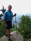
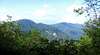
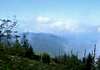
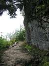
 From the summit.
Waterrock Knob is (as I understand it) the 16th highest peak in eastern USA. From its flanks you can see many of the highest peaks in the area: Guyot, LeConte, Clingman's Dome, Mitchell, etc.
The mountain lies adjacent to the Blue Ridge Parkway and there is both a visitor's center at the foot of the peak, and a trail leading up to the summit. Waterrock is a typical high elevation peak of the Southern Appalachians. From here, it becomes obvious to the viewer how limited, isolated, fragmented, and fragile is the high country in this part of the nation. This mountain reaches into the Candian zone and serves as home to a number of northern plant species.
 |  |  |  |
Getting There
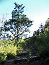
 Along the trail.
The trailhead is located at the parking lot of the Waterrock Knob Visitor's Center on the Blue Ridge Parkway, milepost 451.2.
 |  |  |  |
Red Tape
None. |  |
When To Climb
All year. This portion of the Blue Ridge Parkway is often closed due to inclement weather in the Winter. I know of no trail to the summit, other than the one at the visitor's center.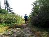 |
Camping
There is camping nearby, in the Great Smoky Mountains National Park (at the Balsam Mountain Campground) and at the nearby private Mile High CampgroundI recently paid $12 (09-03-04) for a campsite at Mile High. Very nice.
 |  |
Mountain Conditions
I would check the weather for Maggie Valley, and subtract five to ten degrees no matter what time of year. |
External Links
- Blue Ridge Parkway.
Official site for the Blue Ridge Parkway, along which Waterrock Knob is located.