

|
|
Area/Range |
|---|---|
|
|
44.16545°N / 71.579°W |
|
|
Hiking |
|
|
Spring, Summer, Fall, Winter |
|
|
Overview
Appalachian Range > White Mountains > Twin & Franconia Ranges
Interactive map of the ranges
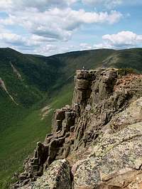
Bondcliff
The Franconia Range forms a well-defined line running north to south along the east side of Franconia Notch. The northern end, past Mt Lafayette, splits west to Eagle Cliff and east to Mount Garfield, and the southern end subsides gradually as Whaleback Mountain ends at the East Branch of the Pemigewasset River in the town of Lincoln.
The Twin range lies to the east of the Franconia Range, with a main ridge running basically north to south from North Twin to Bondcliff, a west-east crossbar ridge from Mt Garfield to Zeacliff, and a further ridge (the Little River Mountains, including Mt Hale) extending north from Zeacliff.
These two ranges are convenient to group together for a few reasons:
- Each individually contains a smaller number of peaks than has heretofore been considered necessary for a useful Range page on Summitpost.
- They are physically joined at Garfield Ridge; there is no obvious notch to form a boundary between them.
- The ridge trails covering the major peaks of both trails can be combined into a well-known long hike, the "Pemigewasset Loop"
- last and least, Owl's Head, which doesn't really belong to either range but is located between them, can be given a home here.
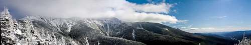
Franconia Ridge.
Both ranges offer fine hiking, including some of New Hampshire's best above-treeline trails outside of the Presidential Range. The Appalachian Trail passes over parts of both, and there are three huts and three campsites or shelters scattered along the combined ridgeline (plus many more camping options in the nearby valleys).
The biggest difference between the two ranges is ease of access. Almost the whole of the Franconia Range can be climbed directly from Interstate 93 in Franconia Notch, making it ideal for day trips from Boston. In contrast, the Twin Range juts into the middle of the Pemigewasset Wilderness, giving several of its peaks some rather long approach hikes. Thus, the Franconia Range is usually far more crowded.
Getting There
Interstate 93 seen from Mt Lafayette
These ranges occupy a central location in the White Mountain National Forest, extending from Interstate 93 on the west half way to route 302 on the east, and from route 3 in the north to route 112 (the Kancamagus Highway) in the south. Look for the stretch of Interstate 93 south of Franconia, NH and north of Lincoln, NH {this stretch makes up Franconia Notch}: the mountains just east of the highway are the Franconia Range, and the Twin Range is just east of those.
Interstate 93 provides a direct route from Boston. From New York City you will want to take 95 to New Haven, then take Interstate 91 to St Johnsbury, VT and then turn south on 93. From Montreal, prenez la 10, puis la 55 qui deviendra la 91, jusqu'a la 93.
Since 2021 the various authorities have teamed up to crack down on parking along the side of Interstate 93. In compensation, there is now a shuttle service that runs every few minutes, 8AM to 8PM, on weekends and holidays, end of May to mid-October, between the Cannon Mountain parking lot (specifically the "Peabody big lot") and the Falling Waters/Lafayette Campground trailhead. Round-trip fare is $5 per person (plus $5 per dog -- driver may refuse to take dogs), cash only.
Trails and Trailheads
Franconia Range
Easiest access is from Interstate 93.
Lafayette Campground Trailhead offers a classic loop over Lincoln, Lafayette, and Little Haystack, feasible in a day for most hikers.
A bit further south, a bit of walking from the Flume or Basin parking areas brings you to another loop over Flume and Liberty. (Warning: the Flume Slide trail is extremely challenging when icy, and still considered difficult when merely wet, which is often.)
Towards the northern end, access to Mt Lafayette can also be had via the Skookumchuck Trail.
From the Lincoln Woods Trailhead on rte 112, access to the southern end of the range is via the Osseo Trail.
The Franconia Ridge Trail runs along the ridge crest for almost the length of the range. At Mt Lafayette, the Garfield Ridge trail turns northeast to meet the Garfield Trail and on Mt Garfield and eventually reaches the Twinway on the western edge of the Twin Range.
Twin Range
Multiple trailheads in the north from small roads, all closed in winter. The easiest route is via Zealand Trail to the Zealand Hut.
Longer options:
From the south, access from Lincoln Woods Trailhead (on route 112 near Lincoln) via Wilderness and Bondcliff trails.
From the east, over or around the Willey Range via A-Z or Ethan Pond trails from Crawford Notch (route 302 near North Conway).
Owl's Head
Getting to this peak is a bigger adventure than climbing it. See the Owl's Head page for suggestions.
Camping

Greenleaf Hut
AMC High Mountain Huts:
Lonesome Lake Hut - on the opposite side of Franconia Notch. Open year-round.
Greenleaf Hut - near the summit of Mt Lafayette.
Galehead Hut - at the col joining Galehead to South Twin.
Zealand Falls Hut - on the east end of Zealand Mountain. Open year-round.
AMC Campsites & Shelters:
(first-come-first-served, but groups of 6 or more must give notice, fee in season)
Kinsman Pond - across Franconia Notch on Mt Kinsman.
Liberty Springs Campsite - on Mt Liberty.
Garfield Ridge Campsite & Shelter - atop Mt Garfield.
13 Falls - southeast of Mt Garfield
Guyot Campsite & Shelter - just south of Mt Guyot
Ethan Pond Campsite & Shelter - south of the Willey Range but within hiking distance of Zealand.
Backcountry Camping
Not permitted within Franconia Notch State Park. In the WMNF, there are restrictions on proximity to trails, water, roads, etc. Extra restrictions in designated wilderness areas (ie, Pemigewasset Wilderness). Complete Rules
Roadside Campgrounds
State-run Campgrounds:
Lafayette - in Franconia Notch, steps from the highway, at a busy trailhead.
WMNF-run Campgrounds:
Zealand - on rte 302 east of the town of Twin Mountain at Zealand Rd ,
Sugarloaf I & Sugarloaf II - on Zealand Rd near Zealand Campgd
Hancock - on Route 112 near the Lincoln Woods trailhead
Big Rock - 1 mile east of Hancock campground
There are other campgrounds on private land nearby, consult a directory such as this one.
Weather Conditions
Bear in mind that the Forecast for the Higher Summits is usually much more severe than the valley forecast represented by the sticker below.

Preparing for the Weather
Weather Conditions is this region vary widely throughout the year.
"In the mountains, there are only two seasons. One of them is called winter." It's not quite that bad here (we have mud season and black fly season), but woe to the unprepared hiker above treeline.
As a rule of thumb, each 1000 feet climbed causes temperatures to drop about five degrees Farenheit, and don't forget about wind chill. New England weather is famously fickle, so pack cautiously.
In summer bring extra clothes as if you are hiking in fall. The weather on the summits are typically twenty degrees cooler than the base. Some days will be 90 degrees with 90 percent humidity even on the summits, and most mountains in this region have elevation gain of around 3000 feet and round trip hike of at least 8 miles, so you don't want to over-pack either. Bug repellent is a must in this region due to the spread of the deadly Triple E and the West Nile Viruses in the region. In very early summer it is also Black Fly season. Black flies bite with a vengeance and can leave scars on your body for weeks.
 semi-permanent cloudbank
Winter in this region is the most unpredictable. It is best to err on the side of caution. Invest warm clothing and be sure you leave no skin exposed to wind. Bring crampons and snowshoes. (Yaktraks will often suffice if staying on well-traveled trails in good weather, but don't count on it.) An ice tool or two is highly recommended for the Flume Slide Trail, but on the other trails hiking poles are a better choice. (Ice axes are fairly popular on Mt Lafayette, but I (nartreb) consider them more dangerous than useful on those trails.) At this time of year it is key to look at the weather forecast. Visibility can drop quickly, so study your route carefully and always be aware of where you are and how far you are from shelter.
Fall is the pretty time but weather is highly unpredictable here. If you are staying overnight in the region be prepared for winter temperatures. If hiking in November and December refer to the winter section. In late September and early October bring your camera but be prepared because the snow starts to fly on the higher peaks at this time.

May snow at Garfield Shelter
Spring is the least desirable time to hike in this region. Eastking's advice is to not hike here until June. If climbing in late March or early April refer to the winter section. Postholing or sinking your feet in 3 feet of wet snow is common in late April and early May. Late May is mud season from snow melt and many of these trails are either still snow covered or mud pits. However late June can be a nice time to hike in this region. Temperatures are very reasonable and providing that you have bug repellent to avoid black flies you should have little problems with weather. Keep in mind that no month is free from the possibilities of snow or severe thunderstorms.
Books & Maps
For the White Mountains generally, the "hiker's bible" is:
AMC White Mountain Guide, $22.00. Includes trail descriptions and topographic maps (on paper).
You can also order tyvek versions of the maps separately for $24.00.