|
|
Area/Range |
|---|---|
|
|
44.50140°N / 70.99005°W |
|
|
Hiking, Canyoneering |
|
|
Spring, Summer, Fall, Winter |
|
|
Mahoosuc Range Overview
The Mahoosuc (ma-HOO-sic) Range is a NE-SW trending arm of the White Mountains straddling the Maine-New Hampshire border. It is bounded on the south and west by the Androscoggin River and on the north-east by Grafton Notch. Located north of the famous Presidentials and far from any of the traditional White Mountain tourist attractions, it sees comparatively little traffic. Only one peak rises above 4000' feet, so even the peak-bagger crowd is minimal, especially in the remote heart of the range.
The Mahoosucs start with the modest, view-ridden mass of Mt. Hayes rising above the Androscoggin in Gorham, NH, and run northeast over a wilderness of humps and ledges past three notable lakes. Several of the peaks in this area are trail-less and probably see less than a dozen ascents each year. Mount Success is the first large summit reached as the range crosses into Maine. From here, the peaks become more organized and taller alternating between broad, glacier-scoured knobs and sharp rocky peaks.
There are at least eight major summits above 3000' in this part of the range and it is wild and remote. Old Speck marks the range's northern end in Grafton Notch State Park, ME, and is the range's only 4000'er.
Mountains, Lakes, and Notable Features
Thusfar, only one Mahoosuc Range mountain is on SummitPost. Hopefully others will join the ranks in the near future. I would happily add several of these peaks myself, but currently lack photos for any of them. Submissions would be great!
Significant features along the range
Listed from north to south with elevations and campsite locations.
| Grafton Notch/ME26 | 1600' | 0.0 | no camping | |||||||||||||||||||||||||||||||||||||||||||||||||||
| Old Speck | 4180' | 2.5 | no camping | |||||||||||||||||||||||||||||||||||||||||||||||||||
| Speck Pond | 3400' | 4.6 | shelter, campsite ($6 fee in season) | |||||||||||||||||||||||||||||||||||||||||||||||||||
| Mahoosuc Arm | 3790' | 5.5 | ||||||||||||||||||||||||||||||||||||||||||||||||||||
| Mahoosuc Mountain | 3490' | 6.2 | ||||||||||||||||||||||||||||||||||||||||||||||||||||
| Mahoosuc Notch | 2300' | 7.1-8.2 | Fulling Mill Mountain | 3450' | 9.2 | shelter, campsite | Goose Eye, North Pk. | 3650' | 10.5 | Goose Eye, East Pk. | 3794' | 11.9 | Goose Eye, West Pk. | 3870' | 12.2 | Mount Carlo | 3565' | 13.5 | Carlo Col | 3200' | 14.1 | shelter, campsite | Mount Success | 3565' | 16.5 | North Baldcap (off trail) |
2893' | ~18 | Gentian Pond | 2160' | 19.3 | shelter, campsite | Dream Lake | 2600' | 21.5 | Bald Cap Bald Cap Peak (off trail) |
3065' 2785' |
~22 | Page Pond | 2230' | 23.2 | Trident Col | 2030' | 24.2 | campsite | Cascade Mountain | 2631' | 25.3 | Mount Hayes | 2555' | 27.0 | Androscoggin River/US2 | 700' | 30.8 |
Trails and Trailheads
Given the remote and rugged nature of the interior of the range, day hikers are few and overnight backpackers are much more common. The main corridor along the Mahoosuc Range is the Appalachian Trail. It runs from Shelburne, NH, all the way over Old Speck to Grafton Notch and is a great way (indeed, really the only way) to experience these mountains.
The 32-mile trek from one end of the range to the other looks decptively easy, especially for someone used to 20+ mile days in the Mid-Atlantic. However, this is one of the toughest, most taxing hikes in the East! Mahoosuc Notch, the deep, boulder-choked slot between the steep cliffs of Fulling Mill and Mahoosuc Mountains, has been described as the toughest single mile on the entire Appalachian Trail. Unlike other contenders for this title, however, it could also be rated one of the most fun miles!
Shelburne Trailheads
Principle access to the range from the south is via trailheads along the North Road in Shelburne, NH. The North Road parallels US Rt2 on the north side of the Androscoggin River from the Reflection Pond to the Maine border. These are popular trails and can be turned into rewarding day-hike loops of 5-10 miles each. From west to east, the trails and trailheads are as follows:
- Centenial Trail (AT) leaves the North Road near the power dam and bridge and climbs up Mt. Hayes.
- Peabody Trail is easy to miss. Travel one mile east from the Centenial Trail on the North Road to a small trailhead on the left. This trail climbs steeply past Giant Falls to Dream Lake.
- Austin Brook Trail leaves the North Road at a white fence another mile east just before crossing the Mill Brook. This trail follows the brook through a confusing network of trails and logging roads eventually reaching a junction. To the left, the trail climbs past Dryad Falls to Dream Lake. To the right, the trail climbs to Gentian Pond.
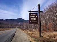
Grafton Notch Trailhead
Old Speck is climbed from a well-marked trailhead in Grafton Notch along ME/NH 26. A steep, well-used trail climbs straight up from the notch to the impressive summit.![Old Speck dominates the...]()
Success Pond Road Access
The northwestern side of the range is accessed via Success Pond Road which starts in Berlin, NH. This road is long, unpaved, difficult to find, and confusing once you get there (but passable for passenger cars). From the junction of US2 and US16 in Gorham, travel north on US16 for 4.5 miles. Cross the Androscoggin at Unity street on the Cleveland Bridge. 0.8 miles past the bridge, the road crosses railroad tracks and becomes Hutchins St. At 1.6 miles it makes a sharp left and continues past a millyard. At 1.9 miles, Success Pond Road begins at a sign marked "OHRV Parking 1 Mile". There are a number of small trailheads along the road interspersed with logging roads and random dead-ends. Be aware that logging trucks, hunters, and other sportspersons use this road and may be driving faster than you'd expect.
By far the most visitted trail on this side of the range is the Mahoosuc Notch Trail 10.9 miles down Success Pond Road from Berlin on a 0.3 mile side road on the right. The Speck Pond Trailhead is another 1.5 miles from Berlin, 0.8 miles down a right-hand side road. Combining these two trails makes a strenuous loop through some of the best country in the range (if you can find it!). Roughly 16 miles from Berlin, the road joins ME26 just north of Grafton Notch.
Camping
The majority of the Mahoosucs are owned either by the State of Maine or by local logging companies. It's not part of the White Mountain National Forest and as such, camping and wood fires are not permitted except at established campsites.
There are four overnight shelters along the range with established campsites nearby. These are listed above. There is also a nice campsite with no facilities at Trident Col. All campsites and shelters are free, first-come, first-serve. Speck Pond Campsite is the one exception with a $6 fee in-season (May-October) when a caretaker is present.Trivia & History
The impressive triple peaks of Goose Eye offer one of the finest views in northern New England. The enigmatic name "Goose Eye" is thought to have arisen from local settlers. In the fall, geese would pass by the triple summits on their way from northern Maine lakes to warmer climes. As they flew, they would appear to graze the tops of the peaks, thus the peaks were "goose high".
Mount Carlo is named after a dog.
The wreckage of a twin-engine DC-3 can be found just off the south side of Mount Success. This is the remains of Northeast Airlines Flight 792 from Laconia to Berlin, NH, that crashed on November 30th, 1954. The plane had seven people on-board at the time five of whom survived and were rescued after two bitterly cold nights spent in the plane. The wreck can still be seen if you know where to look.Conditions