
-
 12069 Hits
-
 84.27% Score
-
 18 Votes
|
|
Route |
|---|---|
|
|
39.11200°N / 107.0803°W |
|
|
Hiking, Mountaineering, Scrambling |
|
|
Spring, Summer, Fall |
|
|
Most of a day |
|
|
Class 3 |
|
|
Overview
 West Face of Snowmass as seen from Geneva Lake
 Top of Snowmass Mountain
This is not the standard route up Snowmass Mountain, but it is getting more popular due to its short approach. It is steeper compared to the standard East Slopes routes, but still does not exceed class 3 difficulty. There is a lot of loose rock on this route.
There is a nice trail all the way to the base of the steeper climbing. You will not find many cairns along this route. I believe that I encountered only 6-7, which would not be enough if you would rely only on following cairns. Luckily, there are many options to go up.
The approach trail is very nice and passes two high alpine lakes and a nice waterfall. The whole area was covered with beautiful wildflowers in July.
I would not recommend to take a pet on this hike although I did bring my. Duchess is an experienced mountain climber, and she has summited more than 100 peaks in Colorado, so her paws are used to loose rock and boulder jumping.
Geneva Lake Trailhead: 9,700 feet Round Trip: 8.2 miles
Geneva Lake: 10,960 feet Round Trip: 4.6 miles
Snowmass Mountain summit 14,092 feet Elevation Gain: 4,392 feet
Getting There
From Carbondale , go 22 miles south on Colorado 133 to the northern base of McClure Pass. I came from the south on this road 133 (from Paonia/Delta).Leave Colorado 133 and turn east to the town of Marble - well signed, paved road. Marble appears to be an interesting community. You have to drive through town, staying on the main road as it is winding through the town. Follow signs to the town of Crystal. The road becomes a dirt road as soon as it leaves town, and high clearance 4WD vehicle is necessary to continue further on. (I would not recommend for passenger cars to try this road). It is about 5.5 miles to the town of Crystal. I continued on a dirt road marked Lead King Basin. I believe that there was only one sign, and at some point I was wondering where I was going, but eventually I did end up at the Geneva Lake Trailhead.
Basically, there are not many signs of this road, and the road does get steep and rough at some section. There is one turn-off, which is shorter, more rockier, and there is a longer road (Shofield Pass Road)- more used, goes over a pass with amazing views of Snowmass area (and tons of wildflowers in July), this road can get very muddy if it rains. I took the longer, less rocky approach, and unfortunately did not measure mileage, but it is long (at least 7-8 miles). Both roads meet eventually, and both road will take you to Geneva Trailhead parking area, which is well marked. There is a smaller parking area just above the Geneva Trailhead one, not signed one, and if you park there, it will shorter your hike by about 1/4 mile. The smaller parking spot has about 4 parking spaces.
Route Description
Start on Geneva Lake Trail - well marked at its start. At 0.2 miles you will enter the Maroon Bells-Snowmass Wilderness, 9,760 feet, and continue 0.25 miles north to a trail junction at 9,900 feet. Take the west (left) trail, there is a sign for Geneva Lake. There are a few switchbacks up the hill with a nice view of a waterfall. You will reach Geneva Lake at 10,960 feet. I have seen people fishing there, so I guess if you are into it, bring your supplies. There are beautiful camping spots around Geneva Lake. You can also see Snowmass Mountain's south and west side rising north of the lake.If you would choose to climb the classic = east slopes (slightly easier) route, you can take hike to Snowmass Lake via 12,400 foot Trail Rider Pass. This pass allows you to visit both the east and the west side of Snowmass. Or, if you would decide to climb the west slopes and descend down via east slopes.
Gerry Roachs in his Colorado 14ers describes 3 different routes up Snowmass accessed from Geneva Lake: West Face, West Rib, and S-ridge.
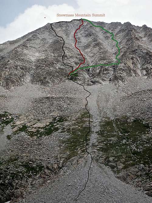 West Face of Snowmass West Face of Snowmass |
I believe that we got onto West Rib (Duchess did not like it very much, and I had to lift her up in many places), red line is the West Face, and we were descending jus below S-ridge.
West Face: This route is little harder than the East slopes standard route, but it is much shorter. It is the most expedient way to climb Snowmass. Hike along Geneva trail on a good trail. You will pass Little Gem Lake at 11,680 feet, and continue on a good trail, which will lead you to the start of your climb. The west face of Snowmass is large, and full of small cliff bands, and loose rock. Look up and you should keep your climbing at class 2+/3. Again, there are not many cairns (at least I have not seen many), so rely on your route finding skills. There are many options. The summit is rewarding, so keep going.
Hiking and scrambling images in order as you approach it
 Start of the trail Start of the trail |  Along the waterfall Along the waterfall |  Geneva Lake Geneva Lake |  Above Geneva Lake Above Geneva Lake |  Little Gem Lake Little Gem Lake |
 Below the steep section Below the steep section |  West Face West Face |  West Rib West Rib |  Climbing dog Climbing dog |  Siberia Lake Siberia Lake |
 Just below the summit Just below the summit |  Summit Summit |  Duchess on #45 fourteneer! Duchess on #45 fourteneer! | 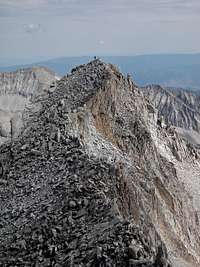 North Snowmass North Snowmass | 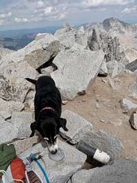 Duchess sniffing geo marker Duchess sniffing geo marker |
 Pretty girl on summit block Pretty girl on summit block |  Descent Descent |  View of Capitol Peak View of Capitol Peak |  Pile of loose rocks Pile of loose rocks |  S-ridge S-ridge |
Essential Gear
Good and reliable hiking shoes/boots. Consider helmet. Trekking poles may be useful on the lower sections, but higher up you will need to use your hands.External Links
West Slope on 14ers.comSome information about Crystal City and Lead King Basin