

|
|
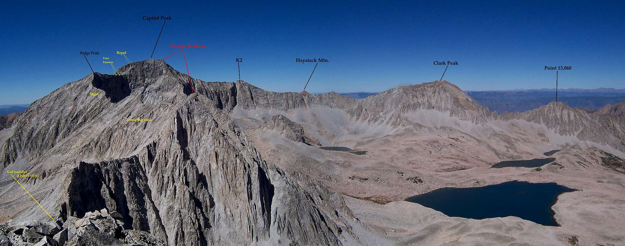
Route |
|---|---|
|
|
39.15030°N / 107.082°W |
|
|
Hiking, Mountaineering, Trad Climbing, Scrambling |
|
|
Summer |
|
|
A few days |
|
|
5.7 (YDS) |
|
|
5.7 R/X |
|
|
V |
|
|
History- Beginnings
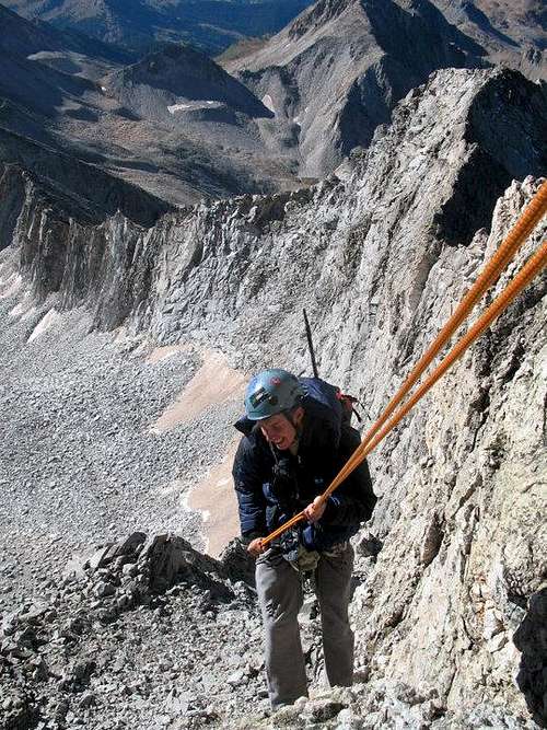
Noah rapping off Capitol first
WARNING: This is a dangerous route. It ranks as probably the most hazardous in Colorado and one of the most unstable in the lower 48 states. Most of this traverse consists of loose 4th class to loose mid 5th class. The rock is chiefly granite but is fractured and broken for most of the length. Loose and unfettered rock is the norm. Stability is the exception. This inimical ridge roughly 2.5 miles long.
Climber beware.
The history of the Capitol-Snowmass Traverse is a rather shy and quiet one. Collequially speaking, there are only four great Fourteener Traverse: The Maroon Bells, El Diente-Mt. Wilson, The Crestone Traverse and more notably, the Blanca-Little Bear Traverse. Technically speaking, there should be five. The Capitol-Snowmass Traverse should be included. Though, due to its' length (~2.5 miles), the completely untrustworthy and rotten quality of the rock, route-finding and technical difficulties due to requiring roped-climbing experience, this traverse, sadly, but quite understandably is typically left off all lists.
This ridge is one of the few places in the state if you should happen to undertake the climb, that untrammeled terrain and solitude will be guaranteed. In my book, that's a HUGE bonus! ![]()
The first ascent (FA) of this ridge occured in (1950-1951?) by Bob Allen and Karl Gustafson. The second ascent came 16 years later in 1966 by Bill Forrest and Glen Denny. For an ascent with absolutely no beta (Allen, Gustafson), I think their climb is truly remarkable. They managed to stay directly to the ridge crest (IE: no dropping to the lower basins to the west) but ultimately had to bail before the climb to North Snowmass due to a fast moving thunderstorm. Gustafson was a student in the Boy Scouts who has since gone on to receive his phD in Mathematics. Bob Allen was a teacher of Karl's in the Boy Scouts.
The 1966 climb achieved by Forrest and Denny didn't see a true ridge-crest commitment. However, due to their original plans of climbing SOuth Maroon, Snowmass Mountain and Capitol Peak from the Outward Camp in Marble in under 24 hours, their focus, needless to say was speed and efficiency. Per Forrest,
July of 1963, Gary Neptune was a student of Paul Petzold's in Outward Bound. Petzold was the chief climbing instructor for OB back then. Out of a group of 6-7 students, Paul let Gary lead the second pitch of the climb of North Snowmass. Two of their original pitons still remain. There is an old photo of their successful climb high on the wall in Gary's store in Boulder (Neptune Mountaineering) above the entrance to the tent/sleeping bag section.
Gary Neptune hasn't been back to do the traverse yet.
In 2000, 'Cave Dog' (Ted E. Keizer) set the speed record for climbing all the Fourteener's. The traverse took him most of the day and he did it in the direction from Snowmass to Capitol. It was the only portion of his quest that he wasn't able to get prior, first-hand recon. Though, due to the severity of the gendarme section below North Snowmass, Cavedog had to drop off the ridge. Though the ridge proper wasn't his focus or intention (speed was), this is quite understandable.
In 2002, Matt Samet climbed the ridge going from Capitol to Snowmass. He goes by the moniker, 'Pinklebear' on Mountainproject.com. He wrote the description on MP. He's quoted by Noah (noahs213) as saying,
Considering Matt's [very] impressive climbing resume on MP, I would seriously consider his climb to be the first true traverse of the ridge proper.
Then there's our climb (Mike Fyton, Steve Gladbach, Noah McKelvin, myself) from 2010.
 |
 |
Labeled Western/Eastern Views of the Traverse. Photos supplied by John Manner.
'Satan's Ridge'
Starting the Traverse Myself in red, Mike in the middle-ground
Descending Capitol: (5.6-5.7)
* The cruxes of this traverse lie at both ends: repelling/climbing Capitol or repelling/climbing Snowmass Mountain.
* Don't trust anything to your full body weight. Keep your balance and body spread out. Rocks that we thought would hold...large, refrigerator-sized blocks of granite even ended up moving on us. It does get mentally taxing.
* This ridge traverse could probably be done just as easily in either direction. Can't really say what would be easier. Also, one could leave via Lead King Basin (shorter descent that would require a car-shuttle), Snowmass Lake back to the trailhead or possibly even via Avalanche Trail back to Capitol Lake.
If the standard 'Knife Ridge' (Northeast Ridge) gave you trouble or pause, don't consider this traverse. Leave Capitol's summit on a chossy scramble in a southwest direction. This is unknown territory. After a couple hundred feet or so, look for a rubble gully on the left (east).
Don't be tempted to descend directly west into a very apparent but prominent bowl. Descending into this feature will be easier but it does cliff out. Mike Fyten scouted this ‘possible descent route’ in 2011 as an alternate to the repel but was denied.
The gully is loose. It’s terrible. Descend this gully one at a time. Descend roughly ~30 feet. The gully will abruptly end at a small ledge climber's left. There is a piton (from either 1951 or 1966) at this pseudo-junction. It is possible to traverse the ledge into a small cave for shelter or rest if need be. Noah tapped the piton and was able to attain a proper ‘thunk’. So it’s still trustworthy (relatively). But of course, back it up if possible.
DO NOT be tempted to down climb the face from the cave to the talus apron below. The descent is further then what appears from the top and the rock is absolute crap. Thankfully, Mike was able to talk me out of doing this. The down climb would be 5.6/5.7-ish.
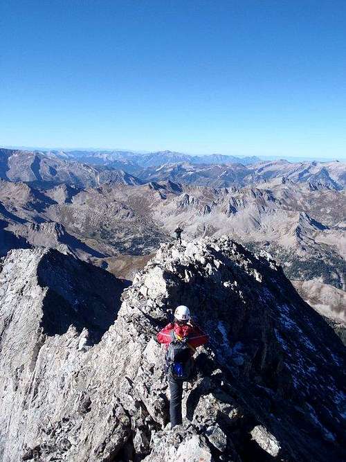
Repel from the piton. The repel is roughly ~130ft (40m). So a single 60m rope will suffice. You will be deposited onto the talus apron below which, leads directly to a long knife ridge. The talus pile continues to the southwest down a moderate slope. Don’t be tempted to follow this. It also cliffs out and the rock on this (west) side is horrible. Cross the edge directly which, leads to two features we called, ‘The Two Towers’. The traverse begins!
The Two Towers: (Difficult 4th)
Keep climbing the knife ridge crest for the first half. The knife portion of this is more exposed and pitched than what’s found on the regular, standard Northeast Ridge Route. The closer to the first of the ‘Two Towers’ you progress, you’ll want to angle to the west side of the crest. Use the crest as a hold if need be. Reason being, the rock becomes more fractured and rotten. At times, it’s just flat-out untrustworthy. It’s a bit precarious because if you fall (to the west), the result will be a decently-sized talus slide. You won’t die but I imagine an injury would be likely. The east side…is nearly vertical.
Stay to the west side while climbing up a crack and small, broken holds. This will access the south side of the first tower (you’ll be in between both gendarmes). The climbing is 4th class, maybe low 5th. It is a little tricky. It’s not necessary to scramble to the top of either tower but it will make for some killer pictures! Keep scrambling on the west side of the second gendarme to regain the crest about 20-30 feet further. Follow the crest proper to the summit of ‘Ridge Peak’ (named by Karl Gustafson circa 1951).
The rock is loose 3rd class. There is a cairn on the summit left by the 1952 team. This is an excellent [and safe!] place to break before the next section.
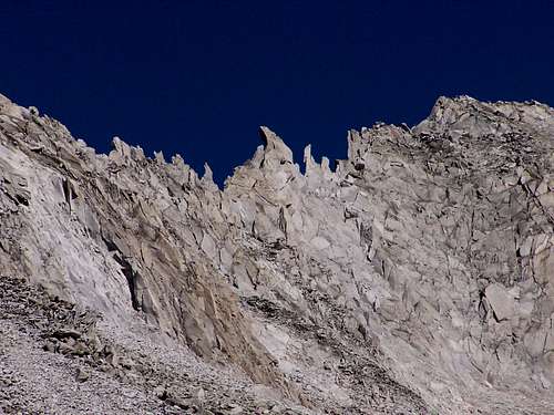
The Slabs: (3rd class-low 5th)

Boilerplate rock
We nicknamed the next part of the traverse, ‘Slabtastic City’. It is by far the most solid and stable portion of the traverse. It’s fairly apparent once you reach it.
Descend off ‘Ridge Peak’ to the southeast. The ridge drops off the summit at a healthy pitch but is nothing more than perhaps hard 3rd class. Keep descending for a couple hundred feet. The rock quality will slowly improve. The slabs will lull you into thinking that the remainder of the ridge will be as equal…it’s not.
Keep to either the crest or slightly west of it when you can. Most of the slabs are very large boilerplate with vertical cracks running throughout. This entire section in terms of rock grade, ranges from 3rd class to low 5th dependent on route-finding of course. The east side (Pierre Lakes Basin) drops steeply at nearly 90°. So again, to reiterate, stay to the crest or west side. This area will definitely work your smearing and friction abilities. It reminded me actually of the ‘Homestretch’ on Longs Peak…only times 500.
From the summit of ‘Ridge Peak’, this entire slab section is fairly apparent because of the four teeth the crest appears to have. It is a little daunting.
If need be, it is possible to escape the ridge along this section to the west.
Center Portion: (3rd class-4th)
There isn't a clear boundary or line as to when the slabs end. The rock simply becomes increasingly fractured, broken and unstable. The center portion of this ridge is fairly long and encompasses most of the distance. Even though the difficulty rachets down to predominantly 3rd class, the rock is by far and away the loosest and most unstable along this section. I was actually finding myself beginning to become mentally taxed by the level of responsibility and deliberate movements to prevent falling, injury or worse (and this is coming from someone who likes the Elk Range choss!).
Gendarme Section
Eventually, the slabs cordone themselves into a loose matrix of choss. The crest will become impassable due to the pinnacles and spires. The east side remains near vertical, so keep moving along the west side. There is a small but fairly moderate point we informally nicknames, 'Mt. Choss'.
It is possible to descend directly to the valley floor at this point (perhaps ~400ft) and simply continue west until the col (lowest point on the traverse) is reached. If you choose to stay high and crest 'Mt. Choss', the climbing will alternate between 3rd class and exposed 4th class on predominantly small dirt and scree ledges. There is some pucker factor along this ascending traverse to the top. The west slope is uncomfortably steep. If one falls along this fragment, they'd more than likely bring down a calvacade of rock upon themselves.
'Mt. Choss' needs to be exercised with due caution.
On the descent to the col, the pinnacles and spires will spring up again, the dirt gradually disappears and the scree will increase in size to talus-quality. The col is a wonderful place to take a break and relax. It is relitively sheltered. If need be, this spot would make for a great bivy site (weather, time, energy). We left a good sized cairn from our last trip.
The next obstacle is a roughly ~600ft scramble to the top of the next point. This climb is only 3rd class but I guarantee, it's a real quad-burner.
The summit of this massive point drops to 2nd class but it is short lived. The jaunt is quick along what feels like a broad 'cat-walk'. The other side however, is guarded by a deeply etched notch. Taken directly, the down climb is low 5th. Descend directly west on steep, parsed-out 4th class ledges and start to angle (traverse) towards the notch. There is another short scramble up perhaps 70-80 feet on class-3 terrain on the other side. The climbing/scrambling remains at 3rd class until the gendarmes are reached. Then, in the words of Gerry Roach, "Consider your future."
You should start seeing Siberia Lake and even Geneva Lake by this point. Siberia Peak is southwest across the basin. It will be a pleasure to see Capitol finally at some distance and Snowmass relitively closer.
If need be, it is possible to escape the ridge along this section to the west and to the east into Pierre Lakes from the summit of the class-2 point ONLY.
Your route-finding and puzzle solving skills are about to get seriously worked.
Gendarme Passage/Snowmass (5.6)
The ridge then turns into your worst nightmare ever. As much as you thought as how it could get any worse. It does. And it gets worse fast.
If you take the ridge direct, expect mid fifth class scary climbing. If you skip them, rappel or down climb a gully to the talus. Traverse the talus past the gendarmes to about 300 feet of 5.6 climbing to get back on the ridge.
If you take the ridge direct, e-mail me and I will give you a detailed description of what to expect and route finding. The route finding is "fairly" straight forward. Go wherever looks less scary.
There is two more pitches of 5.5 that top you out on North Snowmass.
If need be, it is possible to escape the ridge along this section to the west.
There you go, now you finished it! Enjoy solid scrambling to the top of Snowmass and remember the adventure.
(MORE DESCRIPTION TO COME...)
Essential Gear
- 60m rope
- Extra slings
- protection from .5 up to 2.0
- Maybe chocks (no more than two-three pieces)
→ alternate off cams or friends - Few 'biners of course...couple quickdraws
- Approach shoes or boots (no slippers)
- Helmet
- Extra Water or fluids (no sources exist along the ridge)
- Bivy gear would be a "good idea".
External Links

Mountain Project
Mountain Project Description
Capitol Snowmass Traverse Part 1
'Satan's Ridge' Part 1 -Noah McKelvin
Capitol Snowmass Traverse Part 2
'Satan's Ridge' Part 2 -Noah McKelvin
Kiefer's Version/Alt.
The Capitol/Snowmass Traverse
Capitol to Snowmass Traverse- Part I
Cap/Snow Traverse- Day 1 -Mike Fyton (great pictures!)
Capitol to Snowmass Traverse- Part II
Cap/Snow Traverse- Day 2 -Mike Fyton (great pictures!)