
|
|
Mountain/Rock |
|---|---|
|
|
40.59680°N / 110.8309°W |
|
|
Duchesne |
|
|
Hiking |
|
|
11494 ft / 3503 m |
|
|
Overview

History
They found their way down to the lake, and actually found a trail part way down. More than likely, this was made by the Indians. It was eveident that no one knew about the lake in the region. The men had some fly hooks on their hats and some fishing line. They fashioned tome poles from pine boughs and proceeded to fish. Almost as soon as the flies hit the water, they had caught some fish. The area remains a popular fishing destination as well as the entire Uinta Range is.
West Ridge Route
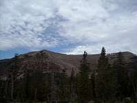
There are no maintained or unmaintained trails to the summit. This is the case with most peaks in the Uintas. From the southwest corner of Mohawk Lake, it a mere .54 miles with an elevation gain of approximately 551 ft.to the saddle on the west ridge. It a pretty steep climb over large boulders on the lower part, then turning to scree and loose dirt as it gets steeper. From the saddle, looking up the ridge you'll see lots a big boulders to scarmble over. It is great fun. It's approximately 708 ft., .53 miles to the summit from the saddle. You will have to go over one false summit, but once on top it's an easy flat walk to the top. Like most peaks in the Uintas, West Grandaddy has a broad, flat summit. There are small patches of scrub pine on the summit. The day we were there, too the south there was a small herd of mountain goats. They were too far away to get a picture, and they bolted as soon as they saw us. I did not see a register, and I didn't bring one. I don't think this peak is climbed very often due to the lack of eveidence. West Grandaddy is listed with an altitude of 11,494 ft. Our GPS reading said 11,541 ft.
Getting There
From Kamas, Utah
Take state road 35 south out of Kamas through the small towns of Francis and Woodland. Continue 34 miles on the road, over Wolf Creek Pass. You'll cross the Duchesne River, than take and immediate left. There is plenty of signage, so you can't miss it. Follw this road, which eventually turns into dirt for 6.5 miles. You will pass a campground, and a dude ranch. Just past the dude ranch tuen right, and you'll see the sign for Grandview Trailhead. This road becomes narrow as it winds up the mountain and eventually into Hades Canyon as you head north. Afte approxaimately 6 miles, you'll reach the Grandview Trailhead. The road ends there.
Trailhead to Grandaddy Basin

Be prepared to see alot of people....scouts. This is probably the quickest and easiest trail into the primative area. It is only 2 miles up to Hades Pass from the TH, and you can practically touch the basin from there. If you're looking for peace and quiet, I would suggest early July or September. But let it be noted. This area is full of bugs. The earlier you are there, the worse it is. Mosquito headnets would be nice to have. Once into the basin, follow the trail and signs to Mohawk lake, or any other lake that is close by. You can reach the peak from any of these lakes without difficulty.
Red Tape
There are no fees to park at the TH or to camp in the wilderness area. However, there are some pretty specific rules to obey once you are at camp. You have to camp at least 200 ft from designated lakes and trails. If you want to have a fire, you need to camp at least 1/4 mile away from any designated body of water. I say designated because, you can go onto the US Forest website, and it has the lakes in the area circled that this pertains to. Most the lakes that are frequented are designated as no fire. But, we found a great campsite right smack in the middle of the area lakes, and it was 1/4 mile away. Some of the smaller ponds and lakes are not designated as no fire zones. Just be smart whatever you do. Backcountry forest rangers do frequent the area, and they will make you move your camp if you are not following the rules.Camping
Places to camp in Grandaddy BasinYou can camp anywhere in the basin as long as you follow the stated rules. Grandaddy Lake and Besty Lake are the two closest lakes to the TH, therefore, they see the most use. You will be able to see and use previously used sites in these areas. Mohawk Lake has some great undeveloped sites, especially on the southern and northern shores. Actually, any lake in the basin is fine.
Nearby campgrounds
On the Kamas side of Wolf Creek Pass, along St.Rd 35, is Mill Hollow Campground. Fees will apply. Uinta Campground just before the dude ranch along the Duchesne River on the way to the TH is also available. Fees apply.
Sarah Simon - Aug 1, 2010 10:20 pm - Hasn't voted
The Ouachita MountainsHey there, The Ouachita Mountains in Arkansas & Oklahoma also run east-west. They are not as grand/major as the Uintas, but are oriented the same none-the-less. Safe climbing! Sarah
imontop - Aug 1, 2010 11:44 pm - Hasn't voted
Re: The Ouachita MountainsHmmmm...... didn't know that. Good to know. Thanks you very much.
smiblee - Jul 16, 2021 7:59 am - Hasn't voted
George BeardThe "George" mentioned in the history section is George Beard, famous Utah painter, explorer and photographer. Another historical account states that the name Grandaddy was coined when George was with John H. Salmon. Lake George Beard (southeast of South King's Peak) is named after George. Mt. Lovenia is named after George's wife, Lovenia.